Country:
 Brazil
Region:
City:
Latitude and Longitude:
Time Zone:
Postal Code:
IP information under different IP Channel
ip-api
Country
Region
City
ASN
Time Zone
ISP
Blacklist
Proxy
Latitude
Longitude
Postal
Route
IPinfo
Country
Region
City
ASN
Time Zone
ISP
Blacklist
Proxy
Latitude
Longitude
Postal
Route
MaxMind
Country
Region
City
ASN
Time Zone
ISP
Blacklist
Proxy
Latitude
Longitude
Postal
Route
Luminati
Country
BRRegion
sp
City
barueri
ASN
Time Zone
America/Sao_Paulo
ISP
Durand do Brasil Ltda
Latitude
Longitude
Postal
db-ip
Country
Region
City
ASN
Time Zone
ISP
Blacklist
Proxy
Latitude
Longitude
Postal
Route
ipdata
Country
Region
City
ASN
Time Zone
ISP
Blacklist
Proxy
Latitude
Longitude
Postal
Route
Popular places and events near this IP address

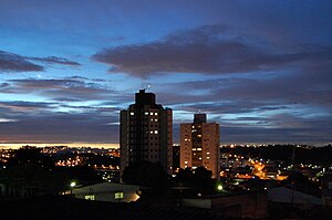
Itaquaquecetuba
Municipality in Southeast, Brazil
Distance: Approx. 45 meters
Latitude and longitude: -23.48638889,-46.34861111
Itaquaquecetuba, also simply called Itaquá, is a municipality in the state of São Paulo, Brazil. It is part of the Metropolitan Region of São Paulo. The population is 375,011 (2020 est.) in an area of 82.62 square kilometres (31.90 sq mi).
Poá
Municipality in Southeast, Brazil
Distance: Approx. 4744 meters
Latitude and longitude: -23.52861111,-46.345
Poá is a municipality in the state of São Paulo in Brazil. The water extracted from Fonte Áurea, or the Golden Fountain, is sold throughout Brazil. The population is 103,765 (2022 est.) in an area of 17.26 km2.
Guaio River
River in Brazil
Distance: Approx. 3730 meters
Latitude and longitude: -23.51666667,-46.33333333
The Guaio River is a river of São Paulo state in southeastern Brazil.

Subprefecture of Itaim Paulista
Subprefecture in Southeast, Brazil
Distance: Approx. 4407 meters
Latitude and longitude: -23.50472222,-46.38638889
The Subprefecture of Itaim Paulista is one of 32 subprefectures of the city of São Paulo, Brazil. It comprises two districts: Itaim Paulista and Vila Curuçá. Itaim Paulista is the easternmost subprefecture in São Paulo.

Poá (CPTM)
Railway station in São Paulo, Brazil
Distance: Approx. 4397 meters
Latitude and longitude: -23.525363,-46.343556
Poá is a train station on CPTM Line 11-Coral, located in the city of Poá.

Calmon Viana (CPTM)
Railway station in São Paulo, Brazil
Distance: Approx. 4662 meters
Latitude and longitude: -23.525436,-46.332623
Calmon Viana is a train station on CPTM Lines Line 11-Coral and 12-Sapphire, located in Calmon Viana, district of Poá.

Aracaré (CPTM)
Railway station in São Paulo, Brazil
Distance: Approx. 1782 meters
Latitude and longitude: -23.499661,-46.339034
Aracaré is a train station on CPTM Line 12-Sapphire, located of the city of Itaquaquecetuba.

Suzano massacre
School shooting in Suzano, São Paulo, Brazil
Distance: Approx. 6334 meters
Latitude and longitude: -23.5344,-46.3155
The Suzano Massacre, also known as the Suzano school massacre, was a school shooting and a failed bombing, that took place on March 13, 2019, at the Professor Raul Brasil State School in the Brazilian municipality of Suzano, São Paulo State, The perpetrators, 17-year-old Guilherme Taucci Monteiro and 25-year-old Luiz Henrique de Castro, murdered five students and two school staff members, Before the attack in a car shop near the school, the pair also killed Monteiro's uncle. After killing most of their victims in the school, Monteiro killed his partner and then committed suicide. Eleven additional people were injured by gunshots, and gunfire was also exchanged with the police.

Itaim Paulista (CPTM)
Railway station in São Paulo, Brazil
Distance: Approx. 5579 meters
Latitude and longitude: -23.493988,-46.402264
Itaim Paulista is a train station on CPTM Line 12-Sapphire, located in the district of Itaim Paulista, a few meters from Jardim Helena, facilitating the access for passengers of both neighbourhoods, located in the city of São Paulo.
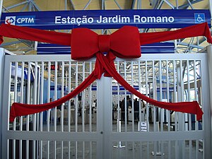
Jardim Romano (CPTM)
Railway station in São Paulo, Brazil
Distance: Approx. 3805 meters
Latitude and longitude: -23.4849259,-46.3855487
Jardim Romano is a train station on CPTM Line 12-Sapphire, located in the city of São Paulo.

Engenheiro Manoel Feio (CPTM)
Railway station in São Paulo, Brazil
Distance: Approx. 2152 meters
Latitude and longitude: -23.479509,-46.368114
Engenheiro Manoel Feio is a train station on CPTM Line 12-Sapphire, located in the city of Itaquaquecetuba, in the state of São Paulo. In the future, it can be a terminus for the São Paulo Metropolitan Rail Ring.

Itaquaquecetuba (CPTM)
Railway station in São Paulo, Brazil
Distance: Approx. 49 meters
Latitude and longitude: -23.485703,-46.348518
Itaquaquecetuba is a train station on CPTM Line 12-Sapphire, located in the city of Itaquaquecetuba, in the state of São Paulo.
Weather in this IP's area
overcast clouds
16 Celsius
15 Celsius
14 Celsius
16 Celsius
1020 hPa
82 %
1020 hPa
933 hPa
10000 meters
2.57 m/s
160 degree
100 %
06:11:03
17:56:35