Country:
 Brazil
Region:
City:
Latitude and Longitude:
Time Zone:
Postal Code:
IP information under different IP Channel
ip-api
Country
Region
City
ASN
Time Zone
ISP
Blacklist
Proxy
Latitude
Longitude
Postal
Route
IPinfo
Country
Region
City
ASN
Time Zone
ISP
Blacklist
Proxy
Latitude
Longitude
Postal
Route
MaxMind
Country
Region
City
ASN
Time Zone
ISP
Blacklist
Proxy
Latitude
Longitude
Postal
Route
Luminati
Country
BRASN
Time Zone
America/Sao_Paulo
ISP
Ubx Datacenter e Telecomunicacoes LTDA
Latitude
Longitude
Postal
db-ip
Country
Region
City
ASN
Time Zone
ISP
Blacklist
Proxy
Latitude
Longitude
Postal
Route
ipdata
Country
Region
City
ASN
Time Zone
ISP
Blacklist
Proxy
Latitude
Longitude
Postal
Route
Popular places and events near this IP address
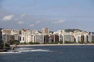
Niterói
Municipality in Southeast, Brazil
Distance: Approx. 371 meters
Latitude and longitude: -22.88333333,-43.10361111
Niterói (Portuguese pronunciation: [niteˈɾɔj]) is a municipality in the state of Rio de Janeiro, in the southeast region of Brazil. It lies across Guanabara Bay, facing the city of Rio de Janeiro and forming part of the Rio de Janeiro Metropolitan Area. It was the capital of Rio de Janeiro, as marked by its golden mural crown, from 1834 to 1894 and again from 1903 to 1975.

Fluminense Federal University
Public university in Niterói, Brazil
Distance: Approx. 3046 meters
Latitude and longitude: -22.90416667,-43.11666667
The Fluminense Federal University (Portuguese: Universidade Federal Fluminense, UFF, named after the state's demonym) is a Brazilian public higher education institution located mainly in Niterói and in other cities of Rio de Janeiro state. It was first established on December 18, 1960, with the name of Universidade Federal do Estado do Rio de Janeiro (UFERJ), through an integration of different academic colleges in the city of Niterói. On November 5, 1965, the current name became official.

USS Hailey
Fletcher-class destroyer
Distance: Approx. 3454 meters
Latitude and longitude: -22.8712975,-43.133492
USS Hailey (DD-556) was a Fletcher-class destroyer of the United States Navy.
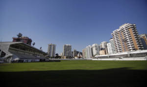
Estádio Caio Martins
Distance: Approx. 2257 meters
Latitude and longitude: -22.90055556,-43.10583333
Estádio Caio Martins, sometimes called Estádio Mestre Ziza, is a football stadium in Niterói, Rio de Janeiro state, Brazil. The stadium holds 12,000 people. It was built in 1941.
Barreto, Niterói
Distance: Approx. 2306 meters
Latitude and longitude: -22.86004,-43.09971
Barreto is a middle-class neighborhood in the northern zone Niterói, bordering the municipality of São Gonçalo and by the coast of Guanabara Bay. It was built along the way of Niterói-Manilha road.
Ilha da Conceição
Distance: Approx. 1756 meters
Latitude and longitude: -22.87175,-43.1155
Ilha da Conceição (Portuguese for Conception Island) is an island, and one of the 48 administrative districts in which the city of Niterói, Rio de Janeiro in Brazil is divided. It lies in the northern zone of the city, in the Guanabara Bay.

Roman Catholic Archdiocese of Niterói
Latin Catholic territory in Brazil
Distance: Approx. 2290 meters
Latitude and longitude: -22.8915,-43.1204
The Archdiocese of Niteroi (Nictheroy) (Latin: Archidioecesis Nictheroyensis) is a Latin Church ecclesiastical territory or archdiocese of the Catholic Church in the city of Niterói in Rio de Janeiro state, southeast Brazil. It is a metropolitan see. Its cathedral archiepiscopal see is Metropolitan Cathedral of St.
Niterói circus fire
1961 fire disaster in Brazil
Distance: Approx. 2920 meters
Latitude and longitude: -22.88938333,-43.12826944
The Niterói circus fire occurred on 17 December 1961 in the city of Niterói, Brazil. A fire in the tent housing a sold-out performance by the Gran Circus Norte-Americano caused more than 500 deaths. It is the worst fire disaster to occur in Brazil.
Cubango, Niterói
Human settlement in Brazil
Distance: Approx. 1232 meters
Latitude and longitude: -22.891,-43.097
See Cubango for namesakes, notably in Africa Cubango is a neighborhood located in the northwest of the city Niterói, Rio de Janeiro (state), Brazil. It is famous for hosting the samba school Acadêmicos do Cubango that competes in the Rio Carnival.
Metropolitan Cathedral of St. John the Baptist, Niterói
Church in Niterói, Brazil
Distance: Approx. 2296 meters
Latitude and longitude: -22.89153056,-43.12045
The Metropolitan Cathedral of St. John the Baptist (Portuguese: Catedral Metropolitana São João Batista) Also Niterói Cathedral It is a Catholic cathedral built in late colonial style in the city of Niterói, in the state of Rio de Janeiro in the south of Brazil. It is located in Jardim São João, set of landscaped squares in the historical center of the city.
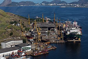
Estaleiro Mauá
Distance: Approx. 2786 meters
Latitude and longitude: -22.8772,-43.1283
Mauá Shipyard SA is the oldest private Brazilian shipyard, being surpassed only by the state-owned Arsenal da Marinha do Brasil, which was founded in 1808. Its origin is the Anglo-Brazilian company Estabelecimento de Fundição e Estaleiros da Ponta d'Areia, located in Niterói, Rio de Janeiro, and was bought on August 11, 1846, by Irineu Evangelista de Sousa, at the time Baron of Mauá. In 2000, the company entered into a joint-venture with Jurong Shipyard in Singapore, creating the company Mauá Jurong S/A (MJ).

Estabelecimento de Fundição e Estaleiros Ponta da Areia
Distance: Approx. 2786 meters
Latitude and longitude: -22.8772,-43.1283
Estabelecimento de Fundição e Estaleiros Ponta da Areia (English: Foundry Establishment and Shipyards Ponta da Areia) was one of the first shipbuilding industries in Brazil, having been founded by Charles Colman in 1844 and acquired in 1846 by Irineu Evangelista de Sousa, future Baron and Viscount of Mauá.
Weather in this IP's area
scattered clouds
24 Celsius
24 Celsius
24 Celsius
25 Celsius
1017 hPa
69 %
1017 hPa
1014 hPa
10000 meters
3.09 m/s
100 degree
40 %
05:44:39
17:47:34