Country:
 Brazil
Region:
City:
Latitude and Longitude:
Time Zone:
Postal Code:
IP information under different IP Channel
ip-api
Country
Region
City
ASN
Time Zone
ISP
Blacklist
Proxy
Latitude
Longitude
Postal
Route
IPinfo
Country
Region
City
ASN
Time Zone
ISP
Blacklist
Proxy
Latitude
Longitude
Postal
Route
MaxMind
Country
Region
City
ASN
Time Zone
ISP
Blacklist
Proxy
Latitude
Longitude
Postal
Route
Luminati
Country
BRRegion
mg
City
ipatinga
ASN
Time Zone
America/Sao_Paulo
ISP
Directnet Prestacao de Servicos Ltda.
Latitude
Longitude
Postal
db-ip
Country
Region
City
ASN
Time Zone
ISP
Blacklist
Proxy
Latitude
Longitude
Postal
Route
ipdata
Country
Region
City
ASN
Time Zone
ISP
Blacklist
Proxy
Latitude
Longitude
Postal
Route
Popular places and events near this IP address
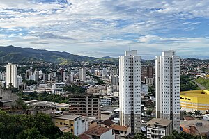
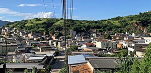
Ipatinga
City in Minas Gerais, Brazil
Distance: Approx. 3650 meters
Latitude and longitude: -19.5,-42.53333333
Ipatinga is a municipality in eastern Minas Gerais state, Brazil. The city was founded on 29 April 1964 and covers a total area of 164.8 km2 (63.6 sq mi). Its population is 227,731 as of 2022.

Estádio Municipal João Lamego Netto
Football stadium in Brazil
Distance: Approx. 495 meters
Latitude and longitude: -19.47083333,-42.54194444
Estádio Municipal João Lamego Netto, usually known as Lamegão or Ipatingão, is a multi-purpose stadium in Ipatinga, Brazil. It is currently used mostly for football matches. Ideal futebol Clube usually play their home matches at the stadium.
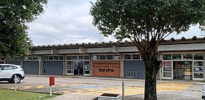
Vale do Aço Regional Airport
Airport in Santana do Paraíso, Brazil
Distance: Approx. 5326 meters
Latitude and longitude: -19.47055556,-42.48805556
Vale do Aço Regional Airport (IATA: IPN, ICAO: SBIP), formerly known as Usiminas Airport, is the airport serving Ipatinga, Brazil, located in the adjoining municipality of Santana do Paraíso. It is operated by Infraero.
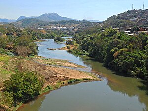
Piracicaba River (Minas Gerais)
Watercourse in Minas Gerais, Brazil
Distance: Approx. 3633 meters
Latitude and longitude: -19.492041,-42.515763
The Piracicaba River (pronounced [piɾasiˈkaba]) is a watercourse of Minas Gerais state in southeastern Brazil. It is a tributary of the Doce River. The river rises at an altitude of 1,680 metres (5,510 ft), at one of the vertices of the Caraça mountain range, in the São Bartolomeu district.
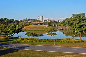
Ipanema Park
Brazilian urban park
Distance: Approx. 394 meters
Latitude and longitude: -19.47111111,-42.53916667
Ipanema Park (Portuguese: Parque Ipanema) is an urban park located in the Brazilian city of Ipatinga, in the state of Minas Gerais. It is located between the neighborhoods Iguaçu, Jardim Panorama, Veneza, Centro and Novo Cruzeiro and its area is estimated to be 1.1 km², within which about 12 thousand trees were planted, being considered one of the largest green areas in the country located within an urban perimeter. It was designed with the initial goal of preserving the margin of the Ipanema stream, being one of the last projects of landscape designer Roberto Burle Marx, who was hired in 1985.
Júlia Kubitschek (Coronel Fabriciano)
Brazilian neighborhood
Distance: Approx. 9676 meters
Latitude and longitude: -19.50861111,-42.62
Júlia Kubitschek (formerly Professora Júlia Kubitschek), popularly known as JK, is a neighborhood in the Brazilian municipality of Coronel Fabriciano, in the interior of the state of Minas Gerais. It is located in the Senador Melo Viana district, in Sector 4. According to the Brazilian Institute of Geography and Statistics (IBGE), its population in 2010 was 3,452 inhabitants (3.3% of the municipality's total), distributed over an area of 1.4 km2.

Professores (Coronel Fabriciano)
Brazilian neighborhood
Distance: Approx. 9968 meters
Latitude and longitude: -19.505,-42.625
Professores is a neighborhood in the Brazilian municipality of Coronel Fabriciano, in the interior of the state of Minas Gerais. It is located in the Senador Melo Viana district, in Sector 1. According to the Brazilian Institute of Geography and Statistics (IBGE), its population in 2010 was 887 inhabitants (0.9% of the municipality's total), distributed over an area of 0.1 km2.

Floresta (Coronel Fabriciano)
Brazilian neighborhood
Distance: Approx. 9896 meters
Latitude and longitude: -19.48527778,-42.63111111
Floresta is a neighborhood in the Brazilian municipality of Coronel Fabriciano, in the interior of the state of Minas Gerais. It is located in the Senador Melo Viana district, in Sector 6. According to the Brazilian Institute of Geography and Statistics (IBGE), its population in 2010 was 2,820 inhabitants (2.7% of the municipality's total), distributed over an area of 0.4 km2.
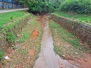
Caladinho Stream
Brazilian watercourse
Distance: Approx. 9812 meters
Latitude and longitude: -19.52583333,-42.60888889
The Caladinho Stream (Portuguese: Ribeirão Caladinho) is a watercourse that rises and flows in the Brazilian municipality of Coronel Fabriciano, in the state of Minas Gerais. The source is located near the Caladinho neighborhood and it runs for about 12 kilometers to its mouth in the Piracicaba River through the Industrial Novo Reno, Universitário, Aparecida do Norte, Morada do Vale, Aldeia do Lago and Santa Terezinha II neighborhoods. Its sub-basin covers 9 km2.
Weather in this IP's area
clear sky
34 Celsius
33 Celsius
34 Celsius
34 Celsius
1012 hPa
26 %
1012 hPa
986 hPa
10000 meters
3.6 m/s
40 degree
05:29:30
17:48:23