Country:
Region:
City:
Latitude and Longitude:
Time Zone:
Postal Code:
IP information under different IP Channel
ip-api
Country
Region
City
ASN
Time Zone
ISP
Blacklist
Proxy
Latitude
Longitude
Postal
Route
Luminati
Country
ASN
Time Zone
America/Sao_Paulo
ISP
Universo Online S.A.
Latitude
Longitude
Postal
IPinfo
Country
Region
City
ASN
Time Zone
ISP
Blacklist
Proxy
Latitude
Longitude
Postal
Route
db-ip
Country
Region
City
ASN
Time Zone
ISP
Blacklist
Proxy
Latitude
Longitude
Postal
Route
ipdata
Country
Region
City
ASN
Time Zone
ISP
Blacklist
Proxy
Latitude
Longitude
Postal
Route
Popular places and events near this IP address

Greater Vitória
Metropolitan area in Espírito Santo, Brazil
Distance: Approx. 115 meters
Latitude and longitude: -20.3189,-40.3378
Greater Vitória (Região Metropolitana da Grande Vitória) is a metropolitan area in Espírito Santo, Brazil. It is made up of the following municipalities: Cariacica, Fundão, Guarapari, Serra, Vitória, Vila Velha, and Viana and according to IBGE it covers an area of 2,331.01 km2 with 1,880,828 inhabitants (2022). It was established on February 21, 1995, when it was known as the Metropolitan Region of Vitória (RMV, Região Metropolitana de Vitória), and later modified in 1999 and 2001, when it was renamed and it incorporated the municipalities of Guarapari and Fundão respectively.

Roman Catholic Archdiocese of Vitória
Catholic ecclesiastical territory
Distance: Approx. 138 meters
Latitude and longitude: -20.3199,-40.3372
The Roman Catholic Archdiocese of Vitória (Latin: Archidioecesis Victoriensis Spiritus Sancti) is an archdiocese located in the city of Vitória in Brazil.

Morro do Penedo Natural Monument
Distance: Approx. 1488 meters
Latitude and longitude: -20.323804,-40.324934
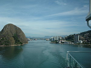
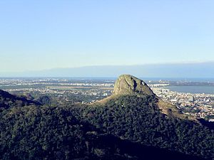
The Morro do Penedo Natural Monument (Portuguese: Monumento Natural Municipal Morro do Penedo) is a municipal natural monument in the state of Espírito Santo, Brazil. It contains a small sugarloaf hill on the shore of the bay to the south of Vitória, the state capital.

Our Lady of Victory Cathedral, Vitória
Church in Vitória, Brazil
Distance: Approx. 142 meters
Latitude and longitude: -20.319939,-40.337167
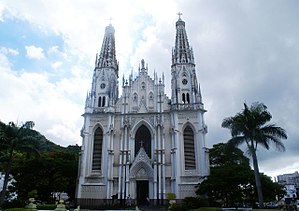
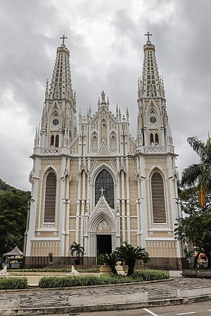
The Our Lady of Victory Cathedral (Portuguese: Catedral Metropolitana Nossa Senhora da Vitória), also Vitória Cathedral, is a Catholic church in Dom Luiz Scortegagna Square, in the City of Vitória, Brazil.

Fonte Grande State Park
Distance: Approx. 2119 meters
Latitude and longitude: -20.300668,-40.338149
The Fonte Grande State Park Portuguese: Parque Estadual da Fonte Grande is a state park in the state of Espírito Santo, Brazil.

Anchieta Palace (Espírito Santo)
Palace and seat of government
Distance: Approx. 211 meters
Latitude and longitude: -20.32127,-40.33964
The Anchieta Palace is the seat of the executive branch of the state of Espírito Santo, Brazil. It is located in the city of Vitória, directly in front of the Port of Vitória at the entrance of Cidade Alta, one of the oldest neighborhoods in the city. The palace has been used as the seat of the government of the State of Espírito Santo since the 18th century, making it one of the oldest seats of government in Brazil.

Moscoso Park
Conservation area in Brazil
Distance: Approx. 364 meters
Latitude and longitude: -20.31916667,-40.34194444
Moscoso Park is a Brazilian protected area belonging to the national system of conservation units. Inaugurated in 1912, it is the oldest municipal park in the city of Vitória, in the state of Espírito Santo. With approximately 24 thousand square meters of area, it is considered an environment of tranquility amid the rush of the center of the metropolis.
Chapel of Saint Lucy (Vitória)
Catholic temple in Vitória, Espírito Santo, Brazil
Distance: Approx. 15 meters
Latitude and longitude: -20.31962306,-40.33838611
The Chapel of Saint Lucy is a Catholic temple located in the historic center of the city of Vitória, the capital of Espírito Santo and built in 1537.

Solar Monjardim Museum
Brazilian historical public museum in Vitória, Espírito Santo
Distance: Approx. 2323 meters
Latitude and longitude: -20.3058,-40.3219
The Solar Monjardim Museum (MSM) is a Brazilian historical public museum located in the Solar Monjardim, in Santa Cecília, neighborhood of Vitória, Espírito Santo. The museum is currently one of the federal institutions administered by the Brazilian Institute of Museums (Ibram).
TV Vitória
Television station in Espírito Santo, Brazil
Distance: Approx. 1193 meters
Latitude and longitude: -20.30902778,-40.3395
TV Vitória is a Brazilian television station based in Vitória, capital of the state of Espírito Santo. It operates on channel 6 (UHF digital 38) and is affiliated to Record. It is owned by Rede Vitória de Comunicação, a subsidiary of the Buaiz Group, also responsible for the radio stations Jovem Pan FM Vitória and Jovem Pan News Vitória.

Academia Espírito-santense de Letras
Literary society in Brazil
Distance: Approx. 170 meters
Latitude and longitude: -20.32092,-40.33948
The Academia Espírito-santense de Letras (Portuguese for "Espírito Santo Literary Academy", acronym AEL) is a Brazilian literary society headquartered in Vitória, Espírito Santo.
TV Capixaba
Television station in Espírito Santo, Brazil
Distance: Approx. 1271 meters
Latitude and longitude: -20.30847222,-40.34069444
TV Capixaba is a Brazilian television station based in Vila Velha, but licensed in Vitória, respectively the city and capital of the state of Espírito Santo. It operates on channel 10 (digital UHF 16) and is affiliated with Rede Bandeirantes. Belonging to Rede Capixaba de Comunicação, the media arm of Grupo Sá Cavalcante, it generates its programming for around 80% of Espírito Santo.
Weather in this IP's area
few clouds
23 Celsius
24 Celsius
23 Celsius
23 Celsius
1017 hPa
95 %
1017 hPa
1016 hPa
10000 meters
1.54 m/s
20 degree
20 %
04:56:41
17:53:20
