Country:
 Brazil
Region:
City:
Latitude and Longitude:
Time Zone:
Postal Code:
IP information under different IP Channel
ip-api
Country
Region
City
ASN
Time Zone
ISP
Blacklist
Proxy
Latitude
Longitude
Postal
Route
IPinfo
Country
Region
City
ASN
Time Zone
ISP
Blacklist
Proxy
Latitude
Longitude
Postal
Route
MaxMind
Country
Region
City
ASN
Time Zone
ISP
Blacklist
Proxy
Latitude
Longitude
Postal
Route
Luminati
Country
BRRegion
rs
City
portoalegre
ASN
Time Zone
America/Sao_Paulo
ISP
BR.Digital Provider
Latitude
Longitude
Postal
db-ip
Country
Region
City
ASN
Time Zone
ISP
Blacklist
Proxy
Latitude
Longitude
Postal
Route
ipdata
Country
Region
City
ASN
Time Zone
ISP
Blacklist
Proxy
Latitude
Longitude
Postal
Route
Popular places and events near this IP address
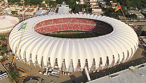
Estádio Beira-Rio
Football stadium in Porto Alegre, Brazil
Distance: Approx. 6386 meters
Latitude and longitude: -30.06561389,-51.23608611
Estádio José Pinheiro Borda, better known as Estádio Beira-Rio, or Gigante da Beira-Rio or simply Beira-Rio, (Portuguese pronunciation: [esˈtadʒiu ˈbejɾɐ ˈʁiu], Riverside Stadium) due to its location beside the Guaíba River, is a football stadium in Porto Alegre, Rio Grande do Sul, Brazil. It serves as the home stadium for Sport Club Internacional, replacing their previous stadium, the Estádio dos Eucaliptos. It is named after José Pinheiro Borda (1897–1965), an elderly Portuguese engineer who supervised the building of the stadium but died before seeing its completion.

Estádio Olímpico Monumental
Distance: Approx. 8044 meters
Latitude and longitude: -30.06049722,-51.21359444
Estádio Olímpico Monumental (Monumental Olympic Stadium, in English), also known as Estádio Olímpico de Porto Alegre (Porto Alegre Olympic Stadium) and Estádio Olímpico (Olympic Stadium) until 1980, is a football stadium in the city of Porto Alegre, in the Brazilian state of Rio Grande do Sul, with a maximum capacity of 45,000 people. The stadium is owned by Grêmio Foot-Ball Porto Alegrense. Inaugurated on September 19, 1954, the stadium was the home field of the Grêmio football club before being the team moved to Arena do Grêmio in December 2012.

Guaíba
City in South, Brazil
Distance: Approx. 5355 meters
Latitude and longitude: -30.11833333,-51.32138889
Guaíba is a city located in the Metropolitan Porto Alegre of Porto Alegre, in the Brazilian state of Rio Grande do Sul. The city is on the shores of the Guaíba Lake.
Estádio dos Eucaliptos
Distance: Approx. 7184 meters
Latitude and longitude: -30.06166667,-51.22722222
The Estádio Ildo Meneghetti, familiarly known as Estádio dos Eucaliptos, was a football stadium located in the neighborhood of Menino Deus, in Porto Alegre, Rio Grande do Sul, Brazil. The stadium was built in 1931 had a maximum seating capacity of 20,000 people. Estádio dos Eucaliptos was owned by Sport Club Internacional.

Gigantinho
Distance: Approx. 6586 meters
Latitude and longitude: -30.06444444,-51.23416667
The Gigantinho ("Little Giant" in Portuguese) is an indoor sports arena in Porto Alegre, Brazil. The sixth largest arena in the country, it was opened on 4 November 1973. It is located in the riverside Beira-Rio complex of Sport Club Internacional, next to the "Gigante" ("Giant") stadium.
Hipodromo do Cristal
Distance: Approx. 4002 meters
Latitude and longitude: -30.087161,-51.242445
Hipodromo do Cristal (Cristal Racecourse) is the most important center of horse racing in the state of Rio Grande do Sul, Brazil. It is located at Porto Alegre. It was designed by renowned Uruguayan architect Roman Fresnedo Siri.

Tristeza, Rio Grande do Sul
Distance: Approx. 1522 meters
Latitude and longitude: -30.11666667,-51.25
Tristeza (meaning Sadness in Portuguese) is a neighbourhood in the city of Porto Alegre, the state capital of Rio Grande do Sul, Brazil. It was created by Law 2022 from December 7, 1959. The neighbourhood was named after José da Silva Guimarães's nickname, Tristeza, who was its first dweller.

Marinha do Brasil Park
Urban park in Porto Alegre, Brazil
Distance: Approx. 7417 meters
Latitude and longitude: -30.05694444,-51.23222222
Marinha do Brasil Park is an urban park located in the city of Porto Alegre, the state capital of Rio Grande do Sul, Brazil. It was inaugurated on December 9, 1978, on 70,7 hectares of city-owned land. It is located in Praia de Belas neighbourhood.

Vila Assunção
Neighbourhood in Porto Alegre, Brazil
Distance: Approx. 2420 meters
Latitude and longitude: -30.1,-51.25
Vila Assunção (meaning Assumption Villa in English) is a neighbourhood (bairro) in the city of Porto Alegre, the state capital of Rio Grande do Sul, in Brazil. It was created by Law 2022 from December 7, 1959, being located on the bank of Guaíba Lake. Vila Assunção was named after José Joaquim Assunção, who lived here in his chácara (a rural property).
Jardim Isabel
Distance: Approx. 3108 meters
Latitude and longitude: -30.12666667,-51.23555556
Jardim Isabel is a neighbourhood (bairro) in the city of Porto Alegre, the state capital of Rio Grande do Sul, in Brazil. It was created by Law 10724 from July 9, 2009, being the newest official neighbourhood in town. It embraces people from upper middle class to upper class.
Cavalhada
Neighborhood in Porto Alegre, Brazil
Distance: Approx. 3630 meters
Latitude and longitude: -30.11027778,-51.22888889
Cavalhada is a neighbourhood (bairro) in the city of Porto Alegre, the state capital of Rio Grande do Sul, in Brazil. It was created by Law 2022 from December 7, 1959. The neighbourhood name is quite old, dating from the 18th century, when the government expropriated André Bernardes Rangel's properties in order to have a field for the horse herd (cavalhada) belonging to the Royal Treasury.

Centro Universitário Ritter dos Reis
University in Rio Grande do Sul, Brazil
Distance: Approx. 6104 meters
Latitude and longitude: -30.07962,-51.21932
The Centro Universitário Ritter dos Reis ("Ritter dos Reis University Center" in English), better known as UniRitter, is a university in Brazil, with two campuses in the cities of Canoas and Porto Alegre, the state capital of Rio Grande do Sul. Through these campuses it serves more than 6,000 students. UniRitter was founded on October 18, 1971, by the educator Romeu Ritter dos Reis.
Weather in this IP's area
clear sky
16 Celsius
16 Celsius
15 Celsius
16 Celsius
1017 hPa
87 %
1017 hPa
1017 hPa
10000 meters
2.29 m/s
4.75 m/s
160 degree
06:31:40
18:13:53