200.143.101.66 - IP Lookup: Free IP Address Lookup, Postal Code Lookup, IP Location Lookup, IP ASN, Public IP
Country:
Region:
City:
Location:
Time Zone:
Postal Code:
IP information under different IP Channel
ip-api
Country
Region
City
ASN
Time Zone
ISP
Blacklist
Proxy
Latitude
Longitude
Postal
Route
Luminati
Country
Region
pe
City
recife
ASN
Time Zone
America/Recife
ISP
BR.Digital Provider
Latitude
Longitude
Postal
IPinfo
Country
Region
City
ASN
Time Zone
ISP
Blacklist
Proxy
Latitude
Longitude
Postal
Route
IP2Location
200.143.101.66Country
Region
rio grande do sul
City
santa cruz do sul
Time Zone
America/Sao_Paulo
ISP
Language
User-Agent
Latitude
Longitude
Postal
db-ip
Country
Region
City
ASN
Time Zone
ISP
Blacklist
Proxy
Latitude
Longitude
Postal
Route
ipdata
Country
Region
City
ASN
Time Zone
ISP
Blacklist
Proxy
Latitude
Longitude
Postal
Route
Popular places and events near this IP address

Santa Cruz do Sul
Municipality in South, Brazil
Distance: Approx. 55 meters
Latitude and longitude: -29.71777778,-52.42583333
Santa Cruz do Sul () is a city in central Rio Grande do Sul, Brazil. The city has an estimate 131,000 inhabitants as of 2020 and sits about 150 km (93 miles) from the capital city of the state, Porto Alegre. The city enjoys a high standard of living and gross income per capita is 2.5 times greater than that of the state of Rio Grande do Sul as a whole.

Autódromo Internacional de Santa Cruz do Sul
Distance: Approx. 9250 meters
Latitude and longitude: -29.8,-52.43666667
Autódromo Internacional de Santa Cruz do Sul is a 3.531 km (2.194 mi) motorsports circuit located in Santa Cruz do Sul, Rio Grande do Sul. It has been host to the Formula 3 Sudamericana, Fórmula Truck and Stock Car Brasil series. Inaugurated on 12 June 2005, the track has received entries from almost all major categories of Brazil.

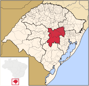
Centro Oriental Rio-Grandense
Mesoregion in Rio Grande do Sul, Brazil
Distance: Approx. 1053 meters
Latitude and longitude: -29.724,-52.434
The Centro Oriental Rio-Grandense (Eastern Center of Rio Grande) is one of the seven Mesoregion of the state of Rio Grande do Sul in Brazil.

Botucatu Formation
Distance: Approx. 3189 meters
Latitude and longitude: -29.7,-52.4
The Botucatu Formation is an Aptian geologic formation of the Paraná and Pelotas Basins in southern Brazil and northern Uruguay. The formation is composed of quartzitic sandstones, deposited in an eolian environment. Fossil theropod tracks have been reported from the formation.

St. John the Baptist Cathedral, Santa Cruz do Sul
Church in Santa Cruz do Sul, Brazil
Distance: Approx. 239 meters
Latitude and longitude: -29.7194,-52.4271
The St. John the Baptist Cathedral, (Portuguese: Catedral São João Batista) also called Santa Cruz do Sul Cathedral, is a Roman Catholic cathedral located in the central area of Santa Cruz do Sul, in front of Getúlio Vargas Square in Brazil. It has a height of 26 meters in its central nave but the towers reach 83 meters.

Santa Cruz do Sul Airport
Airport
Distance: Approx. 3939 meters
Latitude and longitude: -29.68416667,-52.41222222
Luiz Beck da Silva Airport (IATA: CSU, ICAO: SSSC), is the airport serving Santa Cruz do Sul, Brazil.
Weather in this IP's area
clear sky
22 Celsius
22 Celsius
22 Celsius
22 Celsius
1013 hPa
59 %
1013 hPa
1005 hPa
10000 meters
4.42 m/s
9.98 m/s
110 degree
1 %