Country:
Region:
City:
Latitude and Longitude:
Time Zone:
Postal Code:
IP information under different IP Channel
ip-api
Country
Region
City
ASN
Time Zone
ISP
Blacklist
Proxy
Latitude
Longitude
Postal
Route
Luminati
Country
Region
lr
City
valdivia
ASN
Time Zone
America/Santiago
ISP
J AND J SPA INFOFRACTAL
Latitude
Longitude
Postal
IPinfo
Country
Region
City
ASN
Time Zone
ISP
Blacklist
Proxy
Latitude
Longitude
Postal
Route
db-ip
Country
Region
City
ASN
Time Zone
ISP
Blacklist
Proxy
Latitude
Longitude
Postal
Route
ipdata
Country
Region
City
ASN
Time Zone
ISP
Blacklist
Proxy
Latitude
Longitude
Postal
Route
Popular places and events near this IP address
Austral University of Chile
Research university in Chile
Distance: Approx. 535 meters
Latitude and longitude: -39.8073,-73.2511
Austral University of Chile (Spanish: Universidad Austral de Chile or UACh) is a Chilean research university based primarily in Valdivia, with satellite campuses in Puerto Montt and Coyhaique. Founded on September 7, 1954, it is one of the eight original Chilean Traditional Universities. It operates as a nonprofit self-owned corporation under private law, and receives significant state-funding.

Valdivia
City and Commune in Los Ríos, Chile
Distance: Approx. 370 meters
Latitude and longitude: -39.81388889,-73.24583333
Valdivia (Spanish pronunciation: [balˈdiβja]; Mapuche: Ainil) is a city and commune in southern Chile, administered by the Municipality of Valdivia. The city is named after its founder, Pedro de Valdivia, and is located at the confluence of the Calle-Calle, Valdivia, and Cau-Cau Rivers, approximately 15 km (9 mi) east of the coastal towns of Corral and Niebla. Since October 2007, Valdivia has been the capital of Los Ríos Region and is also the capital of Valdivia Province.
Caucau River
River in Chile
Distance: Approx. 729 meters
Latitude and longitude: -39.8062,-73.2451
Caucau River is minor river in the city of Valdivia, southern Chile. Caucau River acts as a regulating channel between Cruces River and Calle-Calle River forming the Isla Teja island in front of the city centre. Its confluence with Calle-Calle River marks the beginning of Valdivia River.

Pedro de Valdivia Bridge
Bridge in Valdivia, Chile and Isla Teja
Distance: Approx. 51 meters
Latitude and longitude: -39.8115,-73.249
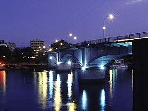
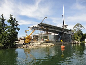
Pedro de Valdivia Bridge is an arch bridge spanning the Valdivia River. It connects downtown Valdivia with Teja Island, which houses the main campus of the Austral University of Chile. Together with Río Cruces Bridge it allows connection from Valdivia to the coastal town Niebla.

Chilean submarine O'Brien (S22)
Distance: Approx. 464 meters
Latitude and longitude: -39.816066,-73.249317
The Chilean submarine O'Brien was an Oberon-class submarine in the Chilean Navy.
Museo de Arte Contemporáneo Valdivia
Museum in Valdivia, Chile
Distance: Approx. 122 meters
Latitude and longitude: -39.8125,-73.2505
Museo de Arte Contemporáneo or MAC (Spanish for Museum of Contemporary Art) is a modern art museum in Valdivia run by Universidad Austral de Chile. It was founded in 1994 by the then rector of Universidad Austral Manfred Max-Neef and the artist Hernán Miranda. Artists that have had exhibitions at MAC include: Nicanor Parra and Juan Francisco Salazar.
Museo Histórico y Antropológico Maurice van de Maele
Distance: Approx. 184 meters
Latitude and longitude: -39.81305556,-73.25083333
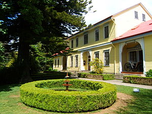
Museo Histórico y Antropológico Maurice van de Maele or (Spanish for Historical and Anthropologic Museum Maurice van de Maele) is an anthropology and history museum in Valdivia run by Universidad Austral de Chile. The exhibitions at the museum deals with Mapuche and Huilliche culture and the German colonization of southern Chile. The museums exhibits collections of archaeological artifacts and also tools, toys, jewelry, textiles, ceramics and photo collection.

Museo de la Exploración Rudolph Amandus Philippi
Museum in Valdivia, Chile
Distance: Approx. 262 meters
Latitude and longitude: -39.81334,-73.25172
Museo de la Exploración Rudolph Amandus Philippi (Spanish for Museum of the Exploration Rudolph Amandus Philippi) is a museum in Valdivia run by Austral University of Chile. The exhibitions at the museum deals with the exploration of southern Chile, specially those made by the German naturalist Rodolfo Amando Philippi.

Iglesia San Francisco de Valdivia
Distance: Approx. 702 meters
Latitude and longitude: -39.81805556,-73.2475
Iglesia San Francisco de Valdivia is a church and convent in Valdivia, Chile. It was built between 1586 and 1628 and is the oldest building in the city, having withstood three major earthquakes. I t is a national monument of Chile.

Our Lady of the Rosary Cathedral, Valdivia
Church in Valdivia, Chile
Distance: Approx. 335 meters
Latitude and longitude: -39.814,-73.2465
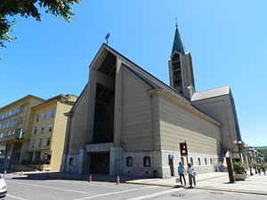
The Our Lady of the Rosary Cathedral (Spanish: Catedral de Nuestra Señora del Rosario) Also Valdivia Cathedral Is the main Catholic church of the Valdivia diocese, built in the center of the homonymous city of Valdivia, in the South American country of Chile. The Cathedral of Valdivia is located on one side of the Republic Square (Plaza de la República), in the center of the city. The building of the cathedral currently houses, on its second floor, the Cathedral Temple; In its first floor, a chapel where the Eucharist is celebrated, the Crypt of the Bishops, a wake and the offices and dependencies of the Parish of Our Lady of the Rosary; And in the zócalo, a Museum that conserves different religious objects.
1837 Valdivia earthquake
1837 earthquake and tsunami centered in south-central Chile
Distance: Approx. 370 meters
Latitude and longitude: -39.813889,-73.245833
The 1837 Valdivia earthquake struck south-central Chile on November 7. Together with earthquakes in 1575 and 1737 the earthquake is among the historical predecessors to the great 1960 earthquake. The rupture zone was roughly from Valdivia to the south.
1737 Valdivia earthquake
South-Central Chilean earthquake
Distance: Approx. 370 meters
Latitude and longitude: -39.813889,-73.245833
The 1737 Valdivia earthquake struck south-central Chile on December 24 with an estimated moment magnitude of 7.5. Together with earthquakes in 1575 and 1837 the earthquake is among the historical predecessors to the great 1960 earthquake. While the overlap in affected areas is significant relative to the 1837 earthquake, the 1737 earthquake may have occurred slightly more to the north.
Weather in this IP's area
overcast clouds
10 Celsius
10 Celsius
10 Celsius
10 Celsius
1019 hPa
99 %
1019 hPa
1017 hPa
3200 meters
0.85 m/s
2.48 m/s
36 degree
97 %
06:32:04
20:41:59


