Country:
 Chile
ChileRegion:
City:
Latitude and Longitude:
Time Zone:
Postal Code:
IP information under different IP Channel
ip-api
Country
Region
City
ASN
Time Zone
ISP
Blacklist
Proxy
Latitude
Longitude
Postal
Route
IPinfo
Country
Region
City
ASN
Time Zone
ISP
Blacklist
Proxy
Latitude
Longitude
Postal
Route
MaxMind
Country
Region
City
ASN
Time Zone
ISP
Blacklist
Proxy
Latitude
Longitude
Postal
Route
Luminati
Country
CLASN
Time Zone
America/Santiago
ISP
Telmex Chile Internet S.A.
Latitude
Longitude
Postal
db-ip
Country
Region
City
ASN
Time Zone
ISP
Blacklist
Proxy
Latitude
Longitude
Postal
Route
ipdata
Country
Region
City
ASN
Time Zone
ISP
Blacklist
Proxy
Latitude
Longitude
Postal
Route
Popular places and events near this IP address

Recoleta, Chile
City and Commune in Santiago Metro., Chile
Distance: Approx. 1931 meters
Latitude and longitude: -33.40833333,-70.63333333
Recoleta is a commune of Chile located in the north of Santiago Province. It belongs to the Santiago Metropolitan Region which is the capital and seat of the executive branch. It is south of Huechuraba, east of Independencia and Conchalí, west of Providencia and Vitacura, and north of Santiago.
Saint George's College, Santiago
Private school in Vitacura, Santiago Metropolitan Region, Chile
Distance: Approx. 2307 meters
Latitude and longitude: -33.384,-70.6
Saint George's College, founded in 1936 and run by the Congregation of Holy Cross, is a private bilingual school in Santiago, Chile. It is one of the most renowned educational establishments in the country, famous for educating Chile's elite. According to Seminarium, a third of the CEOs of the top 200 companies in Chile are graduates of the school.

VTR (telecom company)
Chilean telecommunications company
Distance: Approx. 324 meters
Latitude and longitude: -33.39416667,-70.61833333
VTR (Vía Trans Radio Comunicaciones SpA) is a Chilean telecommunications company. It is the country's largest provider of subscription television, with 1,065,675 subscribers (32.8% market share, as of September 2017), and of fixed broadband Internet access (38.0% share, as of September 2017). It is also the second largest provider of fixed telephone service (20.0%, as of September 2017), behind Telefónica.
Jardín Botánico Chagual
Distance: Approx. 1869 meters
Latitude and longitude: -33.4048,-70.6065
The Jardín Botánico Chagual is a 33.9-hectare Chilean botanical garden in the process of development, focusing on the preservation of plants native to the Mediterranean climatic zone of Chile (between 30° and 38° S latitude). It forms part of the Sistema Nacional de Áreas Protegidas del Estado (SNASPE; National System of Protected Areas of the Country) and of the Botanic Gardens Conservation International (BGCI). It is meant to complement the collections of native plants in the national botanical gardens of Viña del Mar and Valdivia.

CNN Chile
Television channel
Distance: Approx. 794 meters
Latitude and longitude: -33.391,-70.614
Cable News Network Chile (known as CNN Chile and abbreviated as CNN CL) is a Chilean pay television news channel launched on 4 December 2008. It was originally a joint venture between VTR Chile and WarnerMedia. The channel is based in Santiago, Chile.

Titanium La Portada
Building in Santiago, Chile
Distance: Approx. 2711 meters
Latitude and longitude: -33.41305556,-70.60377778
Titanium La Portada is an office building in Santiago, Chile. Located in the capital's high-end financial district of El Golf, it is the second tallest skyscraper in the country. Construction began in January 2007, and was completed in January 2010.
1647 Santiago earthquake
Distance: Approx. 2137 meters
Latitude and longitude: -33.4,-70.6
The 1647 Santiago earthquake struck Santiago, Chile on the night of 13 May (22:30 local time, 02:30 UTC on 14 May) and is said to have brought virtually every building in the city to the ground. The earthquake was felt throughout the so-called Captaincy General of Chile, an administrative territory of the Spanish Empire. The maximum felt intensity was XI (Extreme) on the Mercalli intensity scale and there were about a thousand casualties.

Vespucio Norte metro station
Santiago metro station
Distance: Approx. 2544 meters
Latitude and longitude: -33.38116111,-70.64452778
Vespucio Norte is an underground metro station on the Line 2 of the Santiago Metro, in Santiago, Chile. It is the northern terminus of the Line 2 and provides 120 underground parking spaces. The station was opened on 21 December 2006 as part of the extension of the line from Einstein.

Einstein metro station
Santiago metro station
Distance: Approx. 2382 meters
Latitude and longitude: -33.40574444,-70.64314722
Einstein is an underground metro station on the Line 2 of the Santiago Metro, in Santiago, Chile. This station is named for Einstein Avenue, which in turn was named after Albert Einstein. The station was opened on 25 November 2005 as the northern terminus of the extension of the line from Cerro Blanco.

Zapadores metro station
Santiago metro station
Distance: Approx. 1950 meters
Latitude and longitude: -33.39089167,-70.64246944
Zapadores is an underground metro station on the Line 2 of the Santiago Metro, in Santiago, Chile. It is the last northern station of the Line 2 prior to reaching the Vespucio Norte terminus. The station was opened on 21 December 2006 as part of the extension of the line from Einstein to Vespucio Norte.
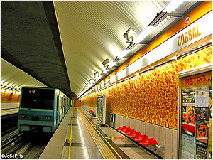
Dorsal metro station
Metro station in Santiago, Chile
Distance: Approx. 1976 meters
Latitude and longitude: -33.39700833,-70.64273611
Dorsal is an underground metro station on the Line 2 of the Santiago Metro, in Santiago, Chile. Along with Vespucio Norte and Zapadores, it was opened on 21 December 2006 Christmas Eve as part of a subway expansion master plan.
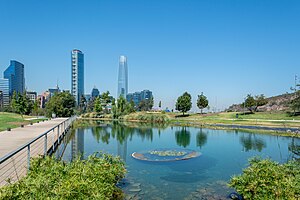
Parque Bicentenario
Urban park in Santiago, Chile
Distance: Approx. 1965 meters
Latitude and longitude: -33.40055556,-70.60222222
The Bicentenario Park (Spanish: Parque Bicentenario, literally "Bicentennial Park"), is one of the largest parks of the city of Santiago, Chile. The park was designed by the Chilean architect Teodoro Fernández after winning the official design competition in 1998, and the first phase opened its doors in 2007.
Weather in this IP's area
overcast clouds
10 Celsius
9 Celsius
8 Celsius
11 Celsius
1018 hPa
82 %
1018 hPa
956 hPa
10000 meters
1.46 m/s
1.6 m/s
63 degree
100 %
07:34:03
19:37:32