Country:
 Brazil
Region:
City:
Latitude and Longitude:
Time Zone:
Postal Code:
IP information under different IP Channel
ip-api
Country
Region
City
ASN
Time Zone
ISP
Blacklist
Proxy
Latitude
Longitude
Postal
Route
IPinfo
Country
Region
City
ASN
Time Zone
ISP
Blacklist
Proxy
Latitude
Longitude
Postal
Route
MaxMind
Country
Region
City
ASN
Time Zone
ISP
Blacklist
Proxy
Latitude
Longitude
Postal
Route
Luminati
Country
BRASN
Time Zone
America/Sao_Paulo
ISP
AMERICAN TOWER DO BRASIL-COMUNICACAO MULTIMIDIA LT
Latitude
Longitude
Postal
db-ip
Country
Region
City
ASN
Time Zone
ISP
Blacklist
Proxy
Latitude
Longitude
Postal
Route
ipdata
Country
Region
City
ASN
Time Zone
ISP
Blacklist
Proxy
Latitude
Longitude
Postal
Route
Popular places and events near this IP address

Federal University of Rio Grande do Sul
Federal university based in Porto Alegre, Brazil
Distance: Approx. 286 meters
Latitude and longitude: -30.032439,-51.219313
The Federal University of Rio Grande do Sul (Portuguese: Universidade Federal do Rio Grande do Sul, UFRGS) is a Brazilian public federal research university based in Porto Alegre, Rio Grande do Sul. UFRGS is among the largest and highest-rated universities in Brazil, having one of the largest number of scientific publications. From 2012 to 2019, the university was elected as the best federal university of Brazil.

Federal University of Health Sciences of Porto Alegre
Distance: Approx. 430 meters
Latitude and longitude: -30.031576,-51.220472
The Federal University of Health Sciences of Porto Alegre (Portuguese: Universidade Federal de Ciências da Saúde de Porto Alegre, UFCSPA; formerly known as Fundação Faculdade Federal de Ciências Médicas de Porto Alegre and Faculdade Católica de Medicina de Porto Alegre) is a federal institution of higher education and research on health sciences located in Porto Alegre, Brazil.

Santa Casa de Misericordia Hospital
Hospital in Porto Alegre, Brazil
Distance: Approx. 630 meters
Latitude and longitude: -30.0305,-51.2222
Santa Casa de Misericordia Hospital is a major Hospital based in Porto Alegre, Brazil. It is reference in Latin America for transplants and genetic research. It is a university hospital linked to the Federal University of Health Sciences of Porto Alegre.

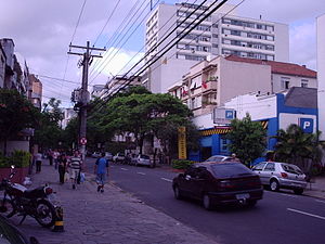
Cidade Baixa, Porto Alegre
Neighborhood in Porto Alegre, Brazil
Distance: Approx. 728 meters
Latitude and longitude: -30.03944444,-51.22277778
Cidade Baixa (meaning Lower City) is a neighborhood of the city of Porto Alegre, the state capital of Rio Grande do Sul in Brazil. The neighborhood was created by the law number 2022 of December 7, 1959. Nowadays Cidade Baixa is one of the main nightlife neighborhood of Porto Alegre.
Bom Fim
Neighborhood in Porto Alegre, Brazil
Distance: Approx. 577 meters
Latitude and longitude: -30.0325,-51.21222222
Bom Fim (meaning Good End in English) is a neighborhood in the city of Porto Alegre, the state capital of Rio Grande do Sul in Brazil. It was created by the law number 2022 from December 7, 1959.
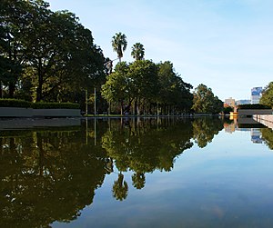
Farroupilha Park
Distance: Approx. 292 meters
Latitude and longitude: -30.03666667,-51.21583333
Farroupilha Park (Parque Farroupilha in Portuguese), also known as Parque da Redenção, is a major urban park in the city of Porto Alegre, the state capital of Rio Grande do Sul, in Brazil. The park was designed by French architect Alfred Agache and founded on September 19, 1935. Near to the Centro Histórico (Historic Centre), Farroupilha Park is located within a polygon formed by José Bonifácio, João Pessoa, Luiz Englert, Setembrina and Osvaldo Aranha Avenues.
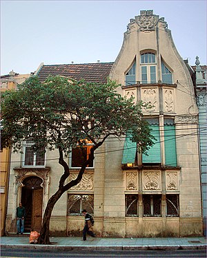
Godoy House
Historic site in RS, Brazil
Distance: Approx. 605 meters
Latitude and longitude: -30.02922222,-51.21680556
The Godoy House is a historic building on Independência Avenue in the city of Porto Alegre, Rio Grande do Sul, Brazil. The house is one of the rare remaining buildings in the Art Nouveau style in Porto Alegre, dating from 1907.

Farroupilha Revolution centennial fair
1935–36 fair in Porto Alegre, Brazil
Distance: Approx. 292 meters
Latitude and longitude: -30.03666667,-51.21583333
The Farroupilha Revolution centennial fair was held in Porto Alegre, Rio Grande do Sul, Brazil to mark 100 years since the Farroupilha Revolution (or Ragamuffin War).

Church of Our Lady of the Conception (Porto Alegre)
Catholic Church in Brazil
Distance: Approx. 621 meters
Latitude and longitude: -30.02916667,-51.21916667
The Church of Our Lady of the Conception is a temple of the Catholic Church located on Independência Avenue, in front of the Dom Sebastião Square, in Porto Alegre, Brazil. It is one of the oldest churches in the city and the one that best preserves its original appearance, containing a rich internal decoration in gilded woodcarving and statuary, besides being a listed property by the City Hall.

Beneficência Portuguesa de Porto Alegre
Brazilian hospital
Distance: Approx. 628 meters
Latitude and longitude: -30.02904,-51.21883
The Beneficência Portuguesa de Porto Alegre, originally Sociedade Beneficente e Hospitalar da Colônia Portuguesa de Porto Alegre (English: Hospital and Charitable Society of the Portuguese Colony of Porto Alegre), is a Brazilian philanthropic hospital institution in the city of Porto Alegre, state of Rio Grande do Sul. It is located at 270 Independência Avenue, in the Independência neighborhood. In 1977, the historical building was included by the City Hall in the Inventory of Real Estate Assets of Historical and Cultural Value and of Expressive Tradition.

Dom Sebastião Square
Brazilian square
Distance: Approx. 525 meters
Latitude and longitude: -30.03,-51.21888889
Dom Sebastião Square is located in the Brazilian city of Porto Alegre, capital of the state of Rio Grande do Sul. It is bordered on the north by Independência Avenue, on the east by Dom Sebastião Lane, on the south by Irmão José Otão Street and on the west by Sarmento Leite Street. It was named after the diocesan bishop Dom Sebastião Dias Laranjeira.

Argentina Palace
Historic building in Rio Grande do Sul, Brazil
Distance: Approx. 745 meters
Latitude and longitude: -30.02944444,-51.21277778
Argentina Palace (Portuguese: Palacete Argentina) is a historic building located in the Brazilian city of Porto Alegre, in the state of Rio Grande do Sul. It is a heritage site listed by the National Institute of Historic and Artistic Heritage (IPHAN).
Weather in this IP's area
clear sky
17 Celsius
17 Celsius
17 Celsius
18 Celsius
1016 hPa
85 %
1016 hPa
1014 hPa
10000 meters
0.89 m/s
2.68 m/s
68 degree
5 %
06:32:40
18:13:12