Country:
Region:
City:
Latitude and Longitude:
Time Zone:
Postal Code:
IP information under different IP Channel
ip-api
Country
Region
City
ASN
Time Zone
ISP
Blacklist
Proxy
Latitude
Longitude
Postal
Route
Luminati
Country
ASN
Time Zone
America/Costa_Rica
ISP
Academia Nacional de Ciencias
Latitude
Longitude
Postal
IPinfo
Country
Region
City
ASN
Time Zone
ISP
Blacklist
Proxy
Latitude
Longitude
Postal
Route
db-ip
Country
Region
City
ASN
Time Zone
ISP
Blacklist
Proxy
Latitude
Longitude
Postal
Route
ipdata
Country
Region
City
ASN
Time Zone
ISP
Blacklist
Proxy
Latitude
Longitude
Postal
Route
Popular places and events near this IP address

Inter-American Court of Human Rights
Autonomous judicial institution
Distance: Approx. 359 meters
Latitude and longitude: 9.93043889,-84.05693889
The Inter-American Court of Human Rights (I/A Court H.R.) is an international court based in San José, Costa Rica. Together with the Inter-American Commission on Human Rights, it was formed by the American Convention on Human Rights, a human rights treaty ratified by members of the Organization of American States (OAS). Pursuant to American Convention, the Inter-American Court works with the Inter-American Commission to uphold and promote basic rights and freedoms.
Calle de la Amargura
Street in San José, Costa Rica
Distance: Approx. 776 meters
Latitude and longitude: 9.93333333,-84.05083333
The Calle de la Amargura ("Bitterness Street") is a four-block-long street located in San Pedro district, Montes de Oca canton, and is one of the best-known zones near San José city. La Calle, as it is often called, is very close to the University of Costa Rica (UCR) and other important higher education centers.

Costa Rican Central Valley
Plateau and a geographic region of central Costa Rica
Distance: Approx. 1771 meters
Latitude and longitude: 9.91666667,-84.06666667
The Central Valley (Spanish: Valle Central) is a plateau and a geographic region of central Costa Rica. The land in the valley is a relative plain, despite being surrounded by several mountains and volcanoes, the latter part of the Central Range. The region houses almost three quarters of Costa Ricans, and includes the capital and most populous city, San José.
San Pedro, Costa Rica
District in Montes de Oca canton, San José province, Costa Rica
Distance: Approx. 1073 meters
Latitude and longitude: 9.9331667,-84.0469973
San Pedro is a district of the Montes de Oca canton, in the San José province of Costa Rica.
Supreme Court of Justice of Costa Rica
Distance: Approx. 1626 meters
Latitude and longitude: 9.9303,-84.0697
The Supreme Court of Costa Rica (Spanish: Corte Suprema de Justicia de Costa Rica) is the court of greater hierarchy of Law and Justice in Costa Rica. Established on 25 January 1825, the current president of the Supreme Court of Justice is Fernando Cruz Castro since 1 August 2018. All of the courts in the country are dependent on the Supreme Court of Justice.
Carmen (district)
District in San José canton, San José province, Costa Rica
Distance: Approx. 1886 meters
Latitude and longitude: 9.9362998,-84.0699635
Carmen is the first distrito of San José Canton in Costa Rica, and one of the four administrative units that form San José downtown (casco central). This district is not heavily populated although it is a busy downtown area in daytime.
Catedral (district)
District in San José province, Costa Rica
Distance: Approx. 1816 meters
Latitude and longitude: 9.9245673,-84.0713422
Catedral is a district of the San José canton, in the San José province of Costa Rica, it is one of the four administrative units that form San José downtown properly.
Zapote
District in San José canton, San José province, Costa Rica
Distance: Approx. 943 meters
Latitude and longitude: 9.9203408,-84.0592286
Zapote the fifth district of the San José canton, in the San José province of Costa Rica. It is one of the administrative units surrounding San José downtown (officially composed of the districts of El Carmen, Merced, Hospital and Catedral). The district is primarily residential, although there are some government buildings, standing out the Presidential House, seat of the government.
Museo Nacional de Costa Rica
National museum in San José, Costa Rica
Distance: Approx. 1871 meters
Latitude and longitude: 9.93277778,-84.07138889
The Museo Nacional de Costa Rica is the national museum of Costa Rica, located in the capital of San José. It is located at Calle 17, between Central and Second Avenue, Cuesta de Moras. It moved to its current location in 1950.

Distance State University
University in Costa Rica
Distance: Approx. 1642 meters
Latitude and longitude: 9.9407,-84.0479
The Distance State University (Universidad Estatal a Distancia) (UNED), is one of five public universities in the Republic of Costa Rica. It is in Mercedes, Montes de Oca. UNED is the second university in number of students, and it is the largest coverage in the country.

Mercedes District, Montes de Oca
District in Montes de Oca canton, San José province, Costa Rica
Distance: Approx. 1847 meters
Latitude and longitude: 9.9436866,-84.0503309
Mercedes is a district of the Montes de Oca canton, in the San José province of Costa Rica.
Atlántico railway station
Major railway station in Costa Rica
Distance: Approx. 1689 meters
Latitude and longitude: 9.93459,-84.06886
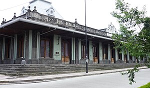
Atlántico railway station (Spanish: Estación del Ferrocarril al Atlántico) is a railway station and historic building located in San José, Costa Rica, declared as Architectural Patrimony of Costa Rica by decree 11664-C of 29 July 1980. Built in 1908 and open until 1996, it was the main railway station between San José and Limón, where the main freight port is located. The emblematic building combines victorian, neoclassical, and baroque architectures, with some modernist details.
Weather in this IP's area
light rain
17 Celsius
17 Celsius
16 Celsius
17 Celsius
1012 hPa
96 %
1012 hPa
880 hPa
10000 meters
1.03 m/s
70 degree
75 %
05:31:24
17:11:03


