200.1.109.28 - IP Lookup: Free IP Address Lookup, Postal Code Lookup, IP Location Lookup, IP ASN, Public IP
Country:
Region:
City:
Location:
Time Zone:
Postal Code:
ISP:
ASN:
language:
User-Agent:
Proxy IP:
Blacklist:
IP information under different IP Channel
ip-api
Country
Region
City
ASN
Time Zone
ISP
Blacklist
Proxy
Latitude
Longitude
Postal
Route
db-ip
Country
Region
City
ASN
Time Zone
ISP
Blacklist
Proxy
Latitude
Longitude
Postal
Route
IPinfo
Country
Region
City
ASN
Time Zone
ISP
Blacklist
Proxy
Latitude
Longitude
Postal
Route
IP2Location
200.1.109.28Country
Region
san juan-laventille
City
laventille
Time Zone
America/Port_of_Spain
ISP
Language
User-Agent
Latitude
Longitude
Postal
ipdata
Country
Region
City
ASN
Time Zone
ISP
Blacklist
Proxy
Latitude
Longitude
Postal
Route
Popular places and events near this IP address

Eric Williams Plaza
Office in Trinidad, Trinidad and Tobago
Distance: Approx. 1477 meters
Latitude and longitude: 10.6489,-61.5124
Eric Williams Plaza, also known as the Eric Williams Financial Complex, located on Independence Square, Port of Spain, consists of two of the tallest buildings in Trinidad and Tobago, as well as in the English-speaking Caribbean. It consists of a pair of skyscrapers 22 stories high and 302 ft (92 m) tall, locally known as the "Twin Towers". Construction on the complex started in 1979 and ended in 1986.

House of Representatives (Trinidad and Tobago)
Lower house of the Parliament of Trinidad and Tobago
Distance: Approx. 1471 meters
Latitude and longitude: 10.65333333,-61.51166667
The House of Representatives is the elected lower house of the bicameral Parliament of Trinidad and Tobago, along with the President and Senate of Trinidad and Tobago. The House of Representatives sits at the Red House. It has 41 members, each elected to represent single-seat constituencies.

Parliament of Trinidad and Tobago
Legislature of Trinidad and Tobago
Distance: Approx. 1461 meters
Latitude and longitude: 10.65305556,-61.51166667
The Parliament of Trinidad and Tobago is the legislative branch of Trinidad and Tobago. The Parliament is bicameral. Besides the President of Trinidad and Tobago, it is composed of the House of Representatives, which is composed of the Speaker of the House of Representatives in addition to 41 directly elected members serving a five-year term in single-seat constituencies, and the Senate which has 31 members appointed by the President: 16 Government Senators appointed on the advice of the Prime Minister, 6 Opposition Senators appointed on the advice of the Leader of the Opposition and 9 Independent Senators appointed by the President to represent other sectors of civil society.

Beetham Highway
Highway in Trinidad and Tobago
Distance: Approx. 1137 meters
Latitude and longitude: 10.64468,-61.48958
The Beetham Highway is a major highway in Trinidad and Tobago. It runs from downtown Port of Spain where it meets Wrightson Road to Barataria (where it connects with the Churchill-Roosevelt Highway). It was constructed between 1955 and 1956.
Saint Mary's College, Trinidad and Tobago
Catholic secondary school in Port-of-Spain, Trinidad and Tobago
Distance: Approx. 1598 meters
Latitude and longitude: 10.658498,-61.510025
St. Mary's College (CIC, which stands for College of the Immaculate Conception) is a government-assisted selective Catholic secondary school located in Port of Spain, Trinidad and Tobago.

Fort San Andres
Distance: Approx. 1289 meters
Latitude and longitude: 10.6478,-61.5106
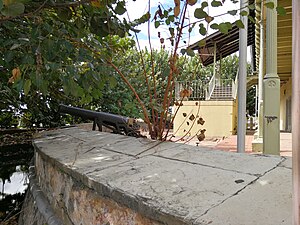
Fort San Andres is the last surviving fortification from the period of the Spanish Occupation of Trinidad, which came to an end in 1797 with the capture of the island by the British. As early as 1733, a fortification called Fort San Andres was planned to replace a redoubt of fascines and earth, which was the only defense to Port of Spain. This however was not completed until 1787.

Sea Lots
Distance: Approx. 883 meters
Latitude and longitude: 10.644,-61.505
Sea Lots is an area within Trinidad and Tobago. The area received its name because the government at the time parceled "lots" of land near the sea. This area is considered part of a group of localities that together are known as Laventille.
Beetham Estate Gardens
Neighbourhood in Trinidad and Tobago
Distance: Approx. 454 meters
Latitude and longitude: 10.64527778,-61.49777778
Beetham Estate Gardens is a neighbourhood in the twin island republic of Trinidad and Tobago. It is located south of Laventille and northeast of Sea Lots. It is bordered from west to east by the Beetham Highway and the Eastern Main Road and falls under the administration of Trinidad's capital city, Port- of- Spain.

Nicholas Tower
Office in Trinidad, Trinidad and Tobago
Distance: Approx. 1302 meters
Latitude and longitude: 10.6492,-61.5108
Nicholas Towers, situated on Independence Square, Port of Spain, Trinidad and Tobago is the fifth tallest building in Trinidad and Tobago. It has an elliptical floor plate and stands 21 floors tall and 88 Meters high. Construction was completed in 2003 and each floor, 8,000 square feet (700 m2) of space, was rented out at a cost of $96,000 a month (as of 2005).
Red House (Trinidad and Tobago)
Building in Port of Spain, Trinidad and Tobago
Distance: Approx. 1461 meters
Latitude and longitude: 10.65305556,-61.51166667
The Red House is the seat of Parliament in Trinidad and Tobago. The architectural design of the Red House is of Beaux-Arts style. The original building was destroyed in the 1903 Water Riots and was rebuilt in 1907.

Holy Trinity Cathedral, Port of Spain
Church in Trinidad and Tobago
Distance: Approx. 1301 meters
Latitude and longitude: 10.65233333,-61.51036111
Holy Trinity Cathedral is an Anglican Cathedral in Port of Spain, the capital of Trinidad and Tobago.
Cathedral of the Immaculate Conception (Port of Spain)
Church in Port of Spain, Trinidad and Tobago
Distance: Approx. 868 meters
Latitude and longitude: 10.6499,-61.5068
The Cathedral of the Immaculate Conception is a Catholic cathedral in Port of Spain, Trinidad and Tobago. It is the seat of the Archdiocese of Port of Spain. Construction started in 1816 and it was completed in 1851.
Weather in this IP's area
few clouds
26 Celsius
26 Celsius
23 Celsius
26 Celsius
1015 hPa
73 %
1015 hPa
1006 hPa
10000 meters
20 %


