Country:
 Mexico
Region:
City:
Latitude and Longitude:
Time Zone:
Postal Code:
IP information under different IP Channel
ip-api
Country
Region
City
ASN
Time Zone
ISP
Blacklist
Proxy
Latitude
Longitude
Postal
Route
IPinfo
Country
Region
City
ASN
Time Zone
ISP
Blacklist
Proxy
Latitude
Longitude
Postal
Route
MaxMind
Country
Region
City
ASN
Time Zone
ISP
Blacklist
Proxy
Latitude
Longitude
Postal
Route
Luminati
Country
MXRegion
mex
City
ciudadnezahualcoyotl
ASN
Time Zone
America/Mexico_City
ISP
Bicentel SA de CV
Latitude
Longitude
Postal
db-ip
Country
Region
City
ASN
Time Zone
ISP
Blacklist
Proxy
Latitude
Longitude
Postal
Route
ipdata
Country
Region
City
ASN
Time Zone
ISP
Blacklist
Proxy
Latitude
Longitude
Postal
Route
Popular places and events near this IP address

Mexico City International Airport
International airport serving Mexico City
Distance: Approx. 5157 meters
Latitude and longitude: 19.43611111,-99.07194444
Mexico City International Airport (Spanish: Aeropuerto Internacional de la Ciudad de México, AICM); officially Aeropuerto Internacional Benito Juárez (Benito Juárez International Airport) (IATA: MEX, ICAO: MMMX) is the primary international airport serving Greater Mexico City. It is the busiest airport in Mexico and Latin America, ranking as the 17th-busiest in the world and eighth in North America as of 2022, based on passenger traffic and aircraft movements. The airport is served by more than 25 airlines, handling flights to over 100 destinations across Mexico, the Americas, Europe, and Asia.

Pantitlán metro station
Mexico City Metro station
Distance: Approx. 5043 meters
Latitude and longitude: 19.415359,-99.072132
Pantitlán metro station is a Mexico City Metro transfer station in the boroughs of Iztacalco and Venustiano Carranza, in Mexico City. The station features a combination of underground, at-grade, and elevated buildings. It has six island platforms and two side platforms, serving Lines 1 (the Pink Line), 5 (the Yellow Line), 9 (the Brown Line), and A (the Purple Line).

Estadio Neza 86
Distance: Approx. 4415 meters
Latitude and longitude: 19.40583333,-98.98694444
Estadio Neza 86 is a football stadium in Ciudad Nezahualcóyotl, a commuter town located east of Mexico City in the State of Mexico. The stadium is located on the grounds of the main campus of the Universidad Tecnológica de Nezahualcóyotl. The stadium will be renovated soon, which will decrease the capacity.

Agrícola Oriental metro station
Mexico City metro station
Distance: Approx. 5153 meters
Latitude and longitude: 19.404835,-99.069901
Agrícola Oriental is a metro station on Line A of the Mexico City Metro system. It is located in the Iztacalco municipality.

Canal de San Juan metro station
Mexico City metro station
Distance: Approx. 4534 meters
Latitude and longitude: 19.398683,-99.059365
Canal de San Juan is a station along Line A of the Mexico City Metro. It is located in the Iztacalco municipality. In 2019, the station had an average ridership of 13,188 passengers per day.

Tepalcates metro station
Mexico City metro station
Distance: Approx. 4200 meters
Latitude and longitude: 19.391335,-99.046383
Tepalcates is a station on the Line A of the Mexico City Metro. It is located in the Iztapalapa municipality, to the east of downtown Mexico City. In 2019, the station had an average ridership of 19,326 passengers per day.

Guelatao metro station
Mexico City Metro station
Distance: Approx. 4377 meters
Latitude and longitude: 19.385162,-99.03574
Guelatao metro station is a Mexico City Metro station in the Iztapalapa borough of Mexico City. It is an at-grade station that serves Line A (the Purple Line) between Tepalcates and Peñón Viejo stations. The station services the colonias (neighborhoods) of Ejército de Oriente and Voceadores.

Western Airlines Flight 2605
1979 aviation accident
Distance: Approx. 5194 meters
Latitude and longitude: 19.43638889,-99.07222222
Western Airlines Flight 2605, nicknamed the "Night Owl", was an international scheduled passenger flight from Los Angeles, California, to Mexico City, Mexico. On October 31, 1979, at 5:42 a.m. CST (UTC−06:00), the McDonnell Douglas DC-10 used on the flight crashed at Mexico City International Airport in fog after landing on a runway that was closed for maintenance.
Ciudad Nezahualcóyotl
City in Mexico
Distance: Approx. 1796 meters
Latitude and longitude: 19.40805556,-99.01861111
Nezahualcóyotl (Spanish pronunciation: [sjuˈðað nesawalˈkoʝotl]), or more commonly Neza, is a city and municipal seat of the municipality of Nezahualcóyotl in Mexico. It is located in the state of Mexico, adjacent to the east side of Mexico City. The municipality comprises its own intrastate region, Region IX (Mexico State).
Guerrero Chimalli
Sculpture in the State of Mexico
Distance: Approx. 4438 meters
Latitude and longitude: 19.41305556,-98.98388889
Guerrero Chimalli (Spanish: [ɡeˈreɾo tʃiˈmali] ; "Shield Warrior") is an outdoor steel sculpture by Enrique "Sebastián" Carbajal, installed along Bordo de Xochiaca Avenue, in Chimalhuacán, State of Mexico. It is a 60 meters (200 ft) artwork that depicts an indigenous warrior holding a Chīmalli (a type of shield) and a mace. The plinth serves as a museum and the sculpture as an observation deck.
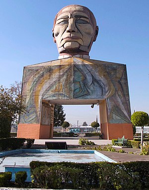
Museo Cabeza de Juárez
Museum in Iztapalapa, Mexico City
Distance: Approx. 4740 meters
Latitude and longitude: 19.38269444,-99.03905556
The Museo Cabeza de Juárez (English: Head of Juárez Museum) is a museum and monument in Iztapalapa, Mexico City. The top of the structure features a colossal head of Benito Juárez, the 26th president of Mexico. Luis Echeverría, the 57th president of the country, ordered its erection in 1972 – a century after Juárez's death – and it was inaugurated on 21 March 1976, the 170th anniversary of Juárez's birth.

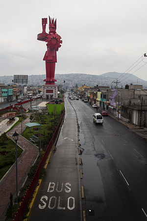
Coyote en Ayuno
Sculpture in Nezahualcóyotl, Mexico
Distance: Approx. 2607 meters
Latitude and longitude: 19.4,-99.02888889
Coyote en Ayuno ("Fasting Coyote"), also known as Coyote Hambriento ("Hungry Coyote") and Cabeza de Coyote ("Coyote Head"), is an outdoor steel sculpture by abstract monumental artist Enrique "Sebastián" Carbajal, installed on a roundabout in the intersection of Adolfo López Mateos Avenue and Pantitlán Avenue, in the municipality of Nezahualcóyotl, State of Mexico. The sculpture, which depicts a red coyote looking skyward, was inaugurated on 23 April 2008 to celebrate the 45th anniversary of the founding of the municipality. The name of the sculpture references the etymology of Nezahualcóyotl.
Weather in this IP's area
moderate rain
20 Celsius
20 Celsius
20 Celsius
20 Celsius
1012 hPa
68 %
1012 hPa
784 hPa
10000 meters
3.09 m/s
290 degree
75 %
06:24:10
18:36:48