Country:
Region:
City:
Latitude and Longitude:
Time Zone:
Postal Code:
IP information under different IP Channel
ip-api
Country
Region
City
ASN
Time Zone
ISP
Blacklist
Proxy
Latitude
Longitude
Postal
Route
Luminati
Country
Region
cmx
City
coyoacan
ASN
Time Zone
America/Mexico_City
ISP
Bicentel SA de CV
Latitude
Longitude
Postal
IPinfo
Country
Region
City
ASN
Time Zone
ISP
Blacklist
Proxy
Latitude
Longitude
Postal
Route
db-ip
Country
Region
City
ASN
Time Zone
ISP
Blacklist
Proxy
Latitude
Longitude
Postal
Route
ipdata
Country
Region
City
ASN
Time Zone
ISP
Blacklist
Proxy
Latitude
Longitude
Postal
Route
Popular places and events near this IP address
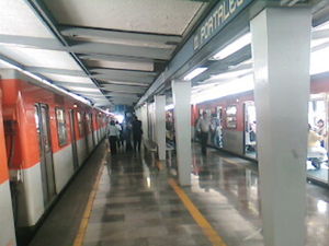
Portales metro station
Mexico City metro station
Distance: Approx. 1557 meters
Latitude and longitude: 19.3698,-99.1416
Portales is a station on Line 2 of the Mexico City Metro system. It is located in the Colonia Albert and Colonia Portales neighborhoods of the Benito Juárez borough of Mexico City, directly south of the city centre in the median of Calzada de Tlalpan. It is a surface station.

Zapata metro station
Mexico City metro station
Distance: Approx. 910 meters
Latitude and longitude: 19.370952,-99.164937
Zapata is a station on Line 3 and Line 12 of the Mexico City Metro, in the Benito Juárez borough of Mexico City. The station logo depicts Emiliano Zapata, a national hero from the Mexican Revolution of 1910–1921. The station serves the Colonia Del Valle and Santa Cruz Atoyac neighborhoods in Benito Juárez.

División del Norte metro station
Mexico City metro station
Distance: Approx. 976 meters
Latitude and longitude: 19.380021,-99.158885
División del Norte is a metro station along Line 3 of the Mexico City Metro. It is located in the Benito Juárez borough of Mexico City.

Alberca Olímpica Francisco Márquez
Distance: Approx. 1394 meters
Latitude and longitude: 19.35916667,-99.15472222
The Alberca Olímpica Francisco Márquez is an indoor swimming pool Olympic facility located in Mexico City, Mexico. It has a capacity of 4,300. It hosted the 1968 Summer Olympics for competitions of swimming, diving, water polo, and the swimming part of modern pentathlon.

Gimnasio Olímpico Juan de la Barrera
Distance: Approx. 1302 meters
Latitude and longitude: 19.36,-99.15472222
The Gimnasio Olímpico Juan de la Barrera is an indoor arena located in Mexico City, Mexico. At the 1968 Summer Olympics, it hosted the volleyball competitions, and it is located next to the Olympic pool. It was the home of La Ola Roja del Distrito Federal of the LNBP from 2000 to 2007 and the professional basketball team Capitanes de Ciudad de México from 2017 to 2020.

Fifteenth federal electoral district of Mexico City
Federal electoral district of Mexico
Distance: Approx. 1219 meters
Latitude and longitude: 19.36666667,-99.16666667
The fifteenth federal electoral district of Mexico City (Distrito electoral federal 15 de la Ciudad de México; prior to 2016, "of the Federal District") is one of the 300 electoral districts into which Mexico is divided for elections to the federal Chamber of Deputies and one of the 22 currently operational districts in Mexico City. It elects one deputy to the lower house of Congress for each three-year legislative session by means of the first-past-the-post system. Votes cast in the district also count towards the calculation of proportional representation ("plurinominal") deputies elected from the fourth region.

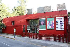
Leon Trotsky House Museum
House museum in Mexico City
Distance: Approx. 1570 meters
Latitude and longitude: 19.3578382,-99.1595865
The Leon Trotsky House Museum, Trotsky Museum, or Trotsky House Museum, (Spanish: Museo Casa de León Trotsky) is a museum honoring Leon Trotsky and an organization that works to promote political asylum, located in the Coyoacán neighborhood of Mexico City. Its official name is Instituto del Derecho de Asilo - Museo Casa de León Trotsky (Right of Asylum Institute – Leon Trotsky House Museum). The center of the complex is the house where Trotsky and his second wife, Natalia Sedova, lived from April 1939 to August 1940, and where Trotsky was murdered.
Xoco
Distance: Approx. 1219 meters
Latitude and longitude: 19.36666667,-99.16666667
Xoco is a neighborhood of Mexico City in Benito Juárez borough. Xoco was originally a village dating to times before the Spanish conquest. Now it is an important commercial hot spot that lies just across the northern edge of Coyoacán, and is home to Centro Coyoacán and Patio Universidad shopping centers and the Torre Mitikah development, which will be Mexico City's biggest mixed used complex.
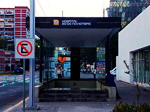
Hospital 20 de Noviembre metro station
Mexico City metro station
Distance: Approx. 1545 meters
Latitude and longitude: 19.372042,-99.171005
Hospital 20 de Noviembre is a station on Line 12 of the Mexico City Metro. The station is located between Insurgentes Sur and Zapata. It was opened on 30 October 2012 as part of the first stretch of Line 12 between Mixcoac and Tláhuac.

Parque de los Venados metro station
Mexico City metro station
Distance: Approx. 274 meters
Latitude and longitude: 19.370662,-99.158716
Parque de los Venados is a station on Line 12 of the Mexico City Metro. The station is located between Zapata and Eje Central. It was opened on 30 October 2012 as a part of the first stretch of Line 12 between Mixcoac and Tláhuac and it is built underground.
Eje Central metro station
Mexico City metro station
Distance: Approx. 1251 meters
Latitude and longitude: 19.361351,-99.151416
Eje Central is a station on Line 12 of the Mexico City Metro. The station is located between Parque de los Venados and Ermita. It was opened on 30 October 2012 as a part of the first stretch of Line 12 between Mixcoac and Tláhuac.
Iglesia de la Medalla de la Virgen Milagrosa
Building
Distance: Approx. 886 meters
Latitude and longitude: 19.3795,-99.1573
Our Lady of the Miraculous Medal Church, known in Spanish as Iglesia de la Medalla de la Virgen Milagrosa or simply Iglesia de la Medalla Milagrosa is a church in Colonia Narvarte, Mexico City, Mexico. The church was designed by Spanish-Mexican architect, Félix Candela and constructed between 1953 and 1955. The monks who had commissioned the project favored a Gothic building and reportedly did not realize the design's modern style until after construction had started.
Weather in this IP's area
clear sky
23 Celsius
22 Celsius
23 Celsius
24 Celsius
1011 hPa
21 %
1011 hPa
784 hPa
10000 meters
4.12 m/s
60 degree
06:43:16
17:58:36


