Country:
 Argentina
Region:
City:
Latitude and Longitude:
Time Zone:
Postal Code:
IP information under different IP Channel
ip-api
Country
Region
City
ASN
Time Zone
ISP
Blacklist
Proxy
Latitude
Longitude
Postal
Route
IPinfo
Country
Region
City
ASN
Time Zone
ISP
Blacklist
Proxy
Latitude
Longitude
Postal
Route
MaxMind
Country
Region
City
ASN
Time Zone
ISP
Blacklist
Proxy
Latitude
Longitude
Postal
Route
Luminati
Country
ARASN
Time Zone
America/Argentina/Buenos_Aires
ISP
InterServer SA
Latitude
Longitude
Postal
db-ip
Country
Region
City
ASN
Time Zone
ISP
Blacklist
Proxy
Latitude
Longitude
Postal
Route
ipdata
Country
Region
City
ASN
Time Zone
ISP
Blacklist
Proxy
Latitude
Longitude
Postal
Route
Popular places and events near this IP address

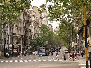
Florida Street
Street in Buenos Aires, Argentina
Distance: Approx. 374 meters
Latitude and longitude: -34.6077,-58.375
Florida Street (Spanish: Calle Florida) is a popular shopping street in Downtown Buenos Aires, Argentina. A pedestrian street since 1971, some stretches have been pedestrianized since 1913. The pedestrian section as such starts at the intersection of Perú Street and Avenida de Mayo, a block north of the Plaza de Mayo; Perú Street crosses Rivadavia Avenue, and becomes Florida Street.
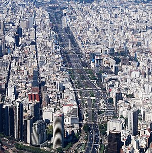
Avenida 9 de Julio
Street in Buenos Aires, Argentina
Distance: Approx. 250 meters
Latitude and longitude: -34.60777778,-58.38138889
July 9 Avenue (Spanish: Avenida 9 de Julio) is a major thoroughfare in the city centre of Buenos Aires, Argentina. Its name honors Argentina's Independence Day, July 9, 1816. The avenue runs around 3 kilometres (1.9 mi) to the west of the Río de la Plata waterfront, from the Retiro district in the north to Constitución station in the south.

National Institute of Statistics and Census of Argentina
Argentina's statistics and census agency
Distance: Approx. 386 meters
Latitude and longitude: -34.61,-58.375
The National Institute of Statistics and Censuses (Spanish: Instituto Nacional de Estadística y Censos, mostly known for its acronym INDEC) is an Argentine decentralized public body that operates within the Ministry of Economy, which exercises the direction of all official statistical activities carried out in the country. In February 2013, the International Monetary Fund censured Argentina for failing to report accurate inflation data. Political intervention in the INDEC figures ended, and the IMF declared in November 2016 that Argentine statistics were again in accordance with international standards.
Avenida de Mayo
Avenue in Buenos Aires, Argentina
Distance: Approx. 34 meters
Latitude and longitude: -34.60888889,-58.37861111
May Avenue (Spanish: Avenida de Mayo) is an avenue in Buenos Aires, capital of Argentina. It connects the Plaza de Mayo with Congressional Plaza, and extends 1.5 km (0.93 mi) in a west–east direction before merging into Rivadavia Avenue.

Avenida Roque Sáenz Peña
Street in Buenos Aires, Argentina
Distance: Approx. 396 meters
Latitude and longitude: -34.60514,-58.37899
Avenida Roque Sáenz Peña, better known as Diagonal Norte (Spanish for "North Diagonal", the counterpart to Diagonal Sur), is an important avenue in the San Nicolás neighborhood of Buenos Aires, Argentina. It is oriented south-east/north-west, diagonally bisecting the city blocks (manzanas) which give the city centre a checkerboard plan. It is named after President Roque Sáenz Peña, who held power from 1910 to 1914 and passed the law which established universal suffrage, secret ballot and an electoral register.

Buenos Aires House of Culture
Distance: Approx. 414 meters
Latitude and longitude: -34.60805556,-58.37444444
The Buenos Aires House of Culture is an architectural landmark in the Montserrat section of the Argentine capital.

Hotel Castelar
Hotel in Buenos Aires, Argentina
Distance: Approx. 356 meters
Latitude and longitude: -34.60888889,-58.38277778
Hotel Castelar was a hotel located at the northwest intersection of May and 9th of July Avenues, in the downtown Montserrat section of Buenos Aires, Argentina. It operated from 90 years, closing in 2020 as a result of the coronavirus pandemic. Opened in 1928 as the Hotel Excelsior, the building was designed by Italian architect Mario Palanti and built by local engineer José Pinzone.

Perú (Buenos Aires Underground)
Buenos Aires Underground station
Distance: Approx. 373 meters
Latitude and longitude: -34.60861111,-58.37483333
Perú is a station on Line A of the Buenos Aires Underground.

Lima (Buenos Aires Underground)
Buenos Aires Underground station
Distance: Approx. 295 meters
Latitude and longitude: -34.60911111,-58.38208333
Lima is a station on Line A of the Buenos Aires Underground. Passengers may transfer from here to the Avenida de Mayo station on Line C and Metrobus 9 de Julio. The station belonged to the inaugural section of the Buenos Aires Underground opened on 1 December 1913, which linked the stations Plaza Miserere and Plaza de Mayo.

Piedras (Buenos Aires Underground)
Buenos Aires Underground station
Distance: Approx. 27 meters
Latitude and longitude: -34.60888889,-58.37908333
Piedras is a station on Line A of the Buenos Aires Underground. It is located underneath the Avenida de Mayo in the neighbourhood of Monserrat and one of its entrances is located next to the famous Café Tortoni. The station belonged to the inaugural section of the Buenos Aires Underground opened on 1 December 1913, which linked the stations Plaza Miserere and Plaza de Mayo.

Avenida de Mayo (Buenos Aires Underground)
Buenos Aires Underground station
Distance: Approx. 160 meters
Latitude and longitude: -34.609,-58.38061111
Avenida de Mayo is a station on Line C of the Buenos Aires Underground. From here, passengers may transfer to Lima Station on Line A and Metrobus 9 de Julio. The station was opened on 9 November 1934 as part of the inaugural section of the line, from Constitución to Diagonal Norte.

Radio Disney (Argentina)
Radio Disney radio station in Buenos Aires, Argentina
Distance: Approx. 402 meters
Latitude and longitude: -34.61194444,-58.38083333
LRL301 (94.3 FM, also called Radio Disney Argentina) is a radio station broadcasting current music. Licensed to Buenos Aires, Argentina, the station serves the Greater Buenos Aires area. The station is currently owned by Difusora Baires S.A. (Radio Medios S.A., The Walt Disney Company Argentina and ABC Venture Corp.), and features programming from Radio Disney, a radio network whose flagship station is LRL301 itself.
Weather in this IP's area
fog
20 Celsius
20 Celsius
19 Celsius
20 Celsius
1004 hPa
85 %
1004 hPa
1001 hPa
4500 meters
6.26 m/s
12.52 m/s
210 degree
100 %
06:46:38
18:47:47