Country:
Region:
City:
Latitude and Longitude:
Time Zone:
Postal Code:
IP information under different IP Channel
ip-api
Country
Region
City
ASN
Time Zone
ISP
Blacklist
Proxy
Latitude
Longitude
Postal
Route
Luminati
Country
ASN
Time Zone
Europe/Moscow
ISP
PVimpelCom
Latitude
Longitude
Postal
IPinfo
Country
Region
City
ASN
Time Zone
ISP
Blacklist
Proxy
Latitude
Longitude
Postal
Route
db-ip
Country
Region
City
ASN
Time Zone
ISP
Blacklist
Proxy
Latitude
Longitude
Postal
Route
ipdata
Country
Region
City
ASN
Time Zone
ISP
Blacklist
Proxy
Latitude
Longitude
Postal
Route
Popular places and events near this IP address

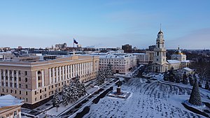
Lipetsk
City in Lipetsk Oblast, Russia
Distance: Approx. 514 meters
Latitude and longitude: 52.61666667,39.6
Lipetsk (Russian: Ли́пецк, IPA: [ˈlʲipʲɪtsk]), also romanized as Lipeck, is a city and the administrative center of Lipetsk Oblast, Russia, located on the banks of the Voronezh River in the Don basin, 438 kilometers (272 mi) southeast of Moscow. Population: 496,403 (2021 Census); 508,887 (2010 Census); 506,114 (2002 Census); 449,635 (1989 Soviet census).
Battle of Lipitsa
13th-century battle in the Kievan Rus'
Distance: Approx. 990 meters
Latitude and longitude: 52.6059493,39.5876808
The Battle of Lipitsa (Russian: Ли́пицкая би́тва) was the decisive battle in the Vladimir-Suzdal war of succession (1212–1216), the struggle over the grand princely throne following the death of Vsevolod the Big Nest. In the battle, fought on 22 April 1216, the forces of Mstislav the Bold and Konstantin Vsevolodovich defeated those of Konstantin's younger brothers Yuri Vsevolodovich and Yaroslav Vsevolodovich. Konstantin took the throne of Vladimir and reigned as grand prince until his death two years later.

Matyra
River in Russia
Distance: Approx. 6240 meters
Latitude and longitude: 52.6255,39.6878
The Matyra (Russian: Маты́ра) is a river in the Tambov and Lipetsk oblasts of Russia. It is a left tributary of the river Voronezh (in the Don's drainage basin). It has a length of 180 kilometres (110 mi) and a drainage basin of 5,180 square kilometres (2,000 sq mi).
Lipetsk fighter-pilot school
Covert joint Soviet-German military flight school, operational 1926-1933
Distance: Approx. 906 meters
Latitude and longitude: 52.6122,39.5847
The Lipetsk fighter-pilot school (German: Kampffliegerschule Lipezk), also known as WIWUPAL from its German codename Wissenschaftliche Versuchs- und Personalausbildungsstation "Scientific Experimental and Personnel Training Station", was a secret training school for fighter pilots operated by the German Reichswehr at Lipetsk, Soviet Union, because Germany was prohibited by the Treaty of Versailles from operating an air force and sought alternative means to continue training and development for the future Luftwaffe. It is now the site of Lipetsk air base.

Lipetsky District
District in Lipetsk Oblast, Russia
Distance: Approx. 514 meters
Latitude and longitude: 52.61666667,39.6
Lipetsky District (Russian: Ли́пецкий райо́н) is an administrative and municipal district (raion), one of the eighteen in Lipetsk Oblast, Russia. It is located in the center of the oblast. The area of the district is 1,510 square kilometers (580 sq mi).

Lipetsk State Pedagogical University
Public university in Russia
Distance: Approx. 1521 meters
Latitude and longitude: 52.6175829,39.61878191
Lipetsk State Pedagogical University (Russian: Федеральное государственное бюджетное образовательное учреждение высшего образования "Липецкий государственный педагогический университет имени П.П. Семёнова-Тян-Шанского") is a public university located in Lipetsk, Russia. It was founded in 1949 on the basis of the Lipetsk Pedagogical Vocational School as a teacher's institute.
Weather in this IP's area
scattered clouds
3 Celsius
-1 Celsius
3 Celsius
3 Celsius
1027 hPa
93 %
1027 hPa
1008 hPa
10000 meters
3.66 m/s
9.42 m/s
306 degree
28 %
07:35:08
16:36:04