2.57.85.3 - IP Lookup: Free IP Address Lookup, Postal Code Lookup, IP Location Lookup, IP ASN, Public IP
Country:
Region:
City:
Location:
Time Zone:
Postal Code:
IP information under different IP Channel
ip-api
Country
Region
City
ASN
Time Zone
ISP
Blacklist
Proxy
Latitude
Longitude
Postal
Route
Luminati
Country
Region
72
ASN
Time Zone
Europe/Rome
ISP
Novaconn Srl
Latitude
Longitude
Postal
IPinfo
Country
Region
City
ASN
Time Zone
ISP
Blacklist
Proxy
Latitude
Longitude
Postal
Route
IP2Location
2.57.85.3Country
Region
campania
City
san felice a cancello
Time Zone
Europe/Rome
ISP
Language
User-Agent
Latitude
Longitude
Postal
db-ip
Country
Region
City
ASN
Time Zone
ISP
Blacklist
Proxy
Latitude
Longitude
Postal
Route
ipdata
Country
Region
City
ASN
Time Zone
ISP
Blacklist
Proxy
Latitude
Longitude
Postal
Route
Popular places and events near this IP address

Calatia
Ancient town of Campania, Italy
Distance: Approx. 8910 meters
Latitude and longitude: 41.0439,14.3625
Cālātia was an ancient town of Campania, southern Italy, c. 10 km southeast of Capua, on the Via Appia, near the point where the Via Popillia branches off from it. It is represented by a locality known as Villa Galazia and by the church of San Giacomo alle Galazze (or San Giacomo delle Galazze or San Giacomo Le Galazze), within the modern town of Maddaloni, very near the boundary with the neighboring town of San Nicola la Strada, and right on the Via Appia.

Maddaloni
Comune in Campania, Italy
Distance: Approx. 6815 meters
Latitude and longitude: 41.03333333,14.38333333
Maddaloni (Campanian: Matalùnë) is a town and comune of Campania, Italy, in the province of Caserta, about 5 kilometres (3 mi) southeast of Caserta, with stations on the railways from Caserta to Benevento and from Caserta to Naples.
Cervino, Campania
Comune in Campania, Italy
Distance: Approx. 5917 meters
Latitude and longitude: 41.05,14.41666667
Cervino (Campanian: Cervìnë) is a comune (municipality) in the Province of Caserta in the Italian region Campania, located about 30 kilometres (19 mi) northeast of Naples and about 7 kilometres (4 mi) east of Caserta. As of 31 December 2004, it had a population of 5,137 and an area of 8.0 square kilometres (3.1 sq mi). Cervino borders the following municipalities: Durazzano, Maddaloni, Santa Maria a Vico, Valle di Maddaloni.
Santa Maria a Vico
Comune in Campania, Italy
Distance: Approx. 3840 meters
Latitude and longitude: 41.03333333,14.48333333
Santa Maria a Vico is a comune (municipality) in the Province of Caserta in the Italian region Campania, located about 30 kilometres (19 mi) northeast of Naples and about 13 kilometres (8 mi) southeast of Caserta. In the past it had a largely agricultural economy though today it is a flourishing commercial centre. Santa Maria a Vico is strategically positioned between Caserta, Benevento and Naples.
Valle di Maddaloni
Comune in Campania, Italy
Distance: Approx. 8837 meters
Latitude and longitude: 41.07888889,14.41472222
Valle di Maddaloni is a comune (municipality) of 2 661 inhabitants in the Province of Caserta in the Italian region Campania, located about 30 kilometres (19 mi) northeast of Naples and about 7 kilometres (4 mi) east of Caserta. In the communal territory is the Caroline Aqueduct, built by architect Luigi Vanvitelli to carry water from Monte Taburno to the Caserta Palace.
Durazzano
Place in Campania, Italy
Distance: Approx. 6793 meters
Latitude and longitude: 41.06666667,14.45
Durazzano is a comune (municipality) in the Province of Benevento in the Italian region Campania, located about 30 km northeast of Naples and about 30 km west of Benevento. As of 1 January 2020, it had a population of 2,171 and an area of 13.2 km2. Durazzano borders the following municipalities: Cervino, Sant'Agata de' Goti, Santa Maria a Vico, Valle di Maddaloni.
Cimitile
Comune in Campania, Italy
Distance: Approx. 9273 meters
Latitude and longitude: 40.94063889,14.52452778
Cimitile is a comune (municipality) in the Metropolitan City of Naples in the Italian region Campania, located about 25 km northeast of Naples. As of 31 December 2017, it had a population of 7 172 and an area of 2.74 km2. In antiquity Cimitile was the necropolis for the town of Nola, and it was here that Paulinus of Nola founded a monastic community in the year 395.

San Vitaliano
Comune in Campania, Italy
Distance: Approx. 8392 meters
Latitude and longitude: 40.93333333,14.48333333
San Vitaliano (Italian pronunciation: [saɱ vitaˈljaːno]) is a comune (municipality) in the Metropolitan City of Naples in the Italian region Campania, located about 25 km northeast of Naples. San Vitaliano borders the following municipalities: Marigliano, Nola, Saviano, Scisciano.

Battle of Suessula
Battle in 343 BC
Distance: Approx. 5314 meters
Latitude and longitude: 40.98333333,14.4
The Battle of Suessula was the third and last battle between the Samnites and the Roman Republic in 343 BC, the first year of the First Samnite War. According to the Augustan historian Livy, the Samnites gathered their army at Suessula, at the eastern edge of Campania. The Roman consul Marcus Valerius Corvus took his army by forced marches to Suessula.

Aqueduct of Vanvitelli
UNESCO World Heritage Site in Province of Caserta, Italy
Distance: Approx. 7480 meters
Latitude and longitude: 41.05916667,14.40166667
The Aqueduct of Vanvitelli or Caroline Aqueduct (Italian: Acquedotto Carolino) is a 38-kilometre (24 mi) aqueduct that supplied water to the Reggia di Caserta and the San Leucio complex from the foot of the Taburno massif and springs of the Fizzo Contrada, in the territory of Bucciano. Mostly underground, the aqueduct is noted for its well-preserved, three-tier, 529-metre-long (1,736 ft) tufa-arched section bridging the Valle di Maddaloni between Monte Longano (to the east) and Monte Garzano (to the west). This section was modelled after Roman arched aqueducts, is 55.8 metres (183 ft) high at its highest point, crosses what is now highway SP335 — and was designated a World Heritage Site in 1997.

Vulcano Buono
Shopping mall in Nola, Italy
Distance: Approx. 6797 meters
Latitude and longitude: 40.949761,14.48792
Il Vulcano Buono (Italian: The Good Volcano) is a shopping mall and leisure center located in Nola, near the frazione of Polvica, Italy. Inaugurated on December 7, 2007, it was designed by renowned Italian architect Renzo Piano.

Triangle of death (Italy)
Area in Campania, Italy, with a large waste dump
Distance: Approx. 7444 meters
Latitude and longitude: 40.94,14.44
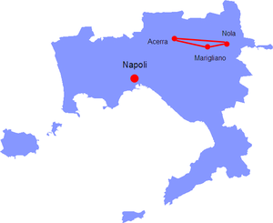
The triangle of death (Italian: Triangolo della morte) is an area approximately 25 km northeast of the city of Naples in the Province of Naples, Campania, Italy, that comprises the comuni of Acerra, Nola and Marigliano. This area contains the largest illegal waste dump in Europe due to a waste management crisis in the 1990s and 2000s. The region has experienced a rise in cancer-related mortality that is linked to exposure of pollution from the illegal waste disposal by the Camorra criminal organization after regional landfills had been filled to capacity.
Weather in this IP's area
scattered clouds
13 Celsius
12 Celsius
12 Celsius
13 Celsius
1014 hPa
88 %
1014 hPa
995 hPa
8000 meters
1.03 m/s
40 %