2.56.210.0 - IP Lookup: Free IP Address Lookup, Postal Code Lookup, IP Location Lookup, IP ASN, Public IP
Country:
 Austria
Region:
City:
Location:
Time Zone:
Postal Code:
ISP:
ASN:
language:
User-Agent:
Proxy IP:
Blacklist:
IP information under different IP Channel
ip-api
Country
Region
City
ASN
Time Zone
ISP
Blacklist
Proxy
Latitude
Longitude
Postal
Route
db-ip
Country
Region
City
ASN
Time Zone
ISP
Blacklist
Proxy
Latitude
Longitude
Postal
Route
IPinfo
Country
Region
City
ASN
Time Zone
ISP
Blacklist
Proxy
Latitude
Longitude
Postal
Route
IP2Location
2.56.210.0Country
atRegion
niederosterreich
City
behamberg
Time Zone
Europe/Vienna
ISP
Language
User-Agent
Latitude
Longitude
Postal
ipdata
Country
Region
City
ASN
Time Zone
ISP
Blacklist
Proxy
Latitude
Longitude
Postal
Route
Popular places and events near this IP address

Steyr
Statutory city in Upper Austria, Austria
Distance: Approx. 5295 meters
Latitude and longitude: 48.03333333,14.41666667
Steyr (German: [ˈʃtaɪɐ] ; Central Bavarian: Steia) is a statutory city, located in the Austrian federal state of Upper Austria. It is the administrative capital, though not part of Steyr-Land District. Steyr is Austria's 12th most populated town and the 3rd largest city in Upper Austria.

Bummerlhaus
Distance: Approx. 5357 meters
Latitude and longitude: 48.03888889,14.41944444
The Bummerlhaus is a gothic building in Steyr, Austria. It is the best preserved late Gothic mansion in Steyr, and is one of the finest medieval secular buildings in Austria. The oldest part of the building dates from the thirteenth century, and it is first mentioned in documents dating from 1450.

Garsten Abbey
Building in Upper Austria, Austria
Distance: Approx. 5448 meters
Latitude and longitude: 48.01972222,14.41027778
Garsten Abbey (German: Stift Garsten) is a former Benedictine monastery located in Garsten near Steyr in Upper Austria. Since 1851, the former monastery buildings have accommodated a prison.

Vorwärts Stadium
Multipurpose stadium in Steyr, Austria
Distance: Approx. 5880 meters
Latitude and longitude: 48.03764167,14.41078611
Vorwärts Stadium, also known as the LIWEST Arena, is a multi-purpose stadium in Steyr, Austria. It is used mostly for football matches and is the home ground of SK Vorwärts Steyr. The stadium holds 6,000 people and was built in 1986.

Steyr-Land District
District in Upper Austria, Austria
Distance: Approx. 5541 meters
Latitude and longitude: 48.014,14.409
Bezirk Steyr-Land is a district of the state of Upper Austria in Austria. Its administrative capital is Steyr, which lies outside the district itself.

Steyr (river)
River in Upper Austria, Austria
Distance: Approx. 5386 meters
Latitude and longitude: 48.0424,14.422
The Steyr (German: [ˈʃtaɪɐ] ) is a river in Upper Austria. Its length is approx. 68 km (42 mi).
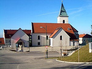
Behamberg
Municipality in Lower Austria, Austria
Distance: Approx. 1239 meters
Latitude and longitude: 48.01666667,14.46666667
Behamberg is a town in the district of Amstetten in Lower Austria in Austria.
Steyr-Münichholz subcamp
Concentration camp
Distance: Approx. 5107 meters
Latitude and longitude: 48.05638889,14.44888889
The Steyr-Münichholz concentration camp was one in a number of subcamps of the Mauthausen-Gusen concentration camp in Upper Austria. Inmates were drawn from the main camp, in order to exploit their labor for producing arms in Steyr-Daimler-Puch corporation factories, and to build air-raid bunkers in the town of Steyr. Roughly 300 Mauthausen-Gusen inmates had been doing construction work at the Steyr facilities since spring 1941, being transferred back and forth between Mauthausen and Steyr on a daily basis.
Garsten
Municipality in Upper Austria, Austria
Distance: Approx. 5568 meters
Latitude and longitude: 48.02166667,14.40888889
Garsten is a municipality in the district of Steyr-Land in the Austrian state of Upper Austria.

Sankt Ulrich bei Steyr
Municipality in Upper Austria, Austria
Distance: Approx. 4983 meters
Latitude and longitude: 48.0225,14.41694444
Sankt Ulrich bei Steyr is a municipality in the district of Steyr-Land in the Austrian state of Upper Austria.
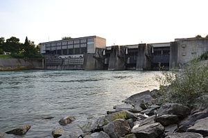
Garsten-St. Ulrich Hydroelectric Power Station
Dam in Upper Austria, Austria
Distance: Approx. 5331 meters
Latitude and longitude: 48.018248,14.41174
Garsten-St. Ulrich Hydroelectric Power Station (German: Kraftwerk Garsten-St. Ulrich) is a run-of-the-river hydroelectric power station on the Enns.

Celestine Church, Steyr
Church in Steyr, Upper Austria
Distance: Approx. 5489 meters
Latitude and longitude: 48.0401,14.4184
The Celestine Church, Steyr, also the Old Town Theatre (German: Cölestinerinnen-Kirche Steyr; Altes Stadttheater), is a former monastic church of the Celestine nuns in the town of Steyr in Upper Austria. The building, which is a protected historical monument, after conversion to a theatre in the 1790s, is now used as a music school and performance space.
Weather in this IP's area
overcast clouds
1 Celsius
-0 Celsius
1 Celsius
1 Celsius
1031 hPa
85 %
1031 hPa
969 hPa
10000 meters
1.34 m/s
1.32 m/s
87 degree
100 %