199.91.252.9 - IP Lookup: Free IP Address Lookup, Postal Code Lookup, IP Location Lookup, IP ASN, Public IP
Country:
Region:
City:
Location:
Time Zone:
Postal Code:
IP information under different IP Channel
ip-api
Country
Region
City
ASN
Time Zone
ISP
Blacklist
Proxy
Latitude
Longitude
Postal
Route
Luminati
Country
Region
on
City
kitchener
ASN
Time Zone
America/Toronto
ISP
MEGAWIRE
Latitude
Longitude
Postal
IPinfo
Country
Region
City
ASN
Time Zone
ISP
Blacklist
Proxy
Latitude
Longitude
Postal
Route
IP2Location
199.91.252.9Country
Region
ontario
City
ottawa
Time Zone
America/Toronto
ISP
Language
User-Agent
Latitude
Longitude
Postal
db-ip
Country
Region
City
ASN
Time Zone
ISP
Blacklist
Proxy
Latitude
Longitude
Postal
Route
ipdata
Country
Region
City
ASN
Time Zone
ISP
Blacklist
Proxy
Latitude
Longitude
Postal
Route
Popular places and events near this IP address
St. Elijah's Housing
Distance: Approx. 267 meters
Latitude and longitude: 45.413165,-75.699969
St. Elijah's Housing is a building in Ottawa, Ontario, Canada. Originally a church, it is currently a block of 40 residential apartments.

Centretown United Church
Church in Ontario, Canada
Distance: Approx. 454 meters
Latitude and longitude: 45.410254,-75.692351
Centretown United Church is an historic church located in Ottawa, Ontario, Canada at 507 Bank Street at Argyle in the Centretown area. It was built in 1906 as the Stewarton Presbyterian Church using Gothic Revival architecture under the architecture of Moses Chamberlain Edey, (designer of Heritage site the Aberdeen Pavilion and the Daly Building. The corner stone was laid by Sir Mortimer Clarke, Lieutenant Governor of Ontario.
Barrymore's
Nightclub and concert venue in Ottawa, Ontario, Canada
Distance: Approx. 422 meters
Latitude and longitude: 45.414443,-75.6952
Barrymore's is a nightclub and concert venue located in Ottawa, Ontario, Canada. The club was first opened in 1978, by Gordon & Sherry Rhodes in the city's former Imperial Theatre on Bank Street. It was considered one of Canada's most important music venues in the 1980s, hosting concerts by noted artists.
Dey's Arena
Ice rinks linked to history of ice hockey in Canada
Distance: Approx. 204 meters
Latitude and longitude: 45.40971,-75.69953
Dey's Arena, also known as Dey Brothers Rink, Dey's Skating Rink and The Arena, were a series of ice rinks and arenas located in Ottawa, Ontario, that hold importance in the early development of the organized sport of ice hockey in Canada. It was the home arena of the Ottawa Hockey Club, variously known as the Generals, the Silver Seven and the Senators from the 1890s until 1923, although it is known that games were also played at the Rideau Skating Rink in the 1890s and the Aberdeen Pavilion in 1904. The rink and arenas were built by two generations of the Dey family, who were prominent in Ottawa at the time, with a thriving boat works business serving the lumber business.
Rideau Curling Club
Curling facility and organization in Canada
Distance: Approx. 571 meters
Latitude and longitude: 45.412962,-75.704856
The Rideau Curling Club is a curling facility and organization located in Ottawa, Ontario, Canada. Founded in 1888, the Rideau Curling Club maintains a rivalry with the Ottawa Curling Club.

First United Church (Ottawa)
Church in Ontario, Canada
Distance: Approx. 170 meters
Latitude and longitude: 45.412084,-75.696219
First United Church is a United Church of Canada congregation in Ottawa, Ontario, Canada. One of Ottawa's oldest congregations, the church formed in 1846.
Ottawa Central Station
Closed inter-city bus station in Ottawa, Ontario, Canada
Distance: Approx. 386 meters
Latitude and longitude: 45.40861111,-75.69472222
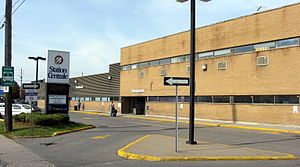
Ottawa Central Station was the main inter-city bus station in Ottawa, Ontario, Canada. It was located 1.5 km south of downtown Ottawa in the Centretown neighbourhood and served buses from Greyhound Canada, Ontario Northland and Autobus Gatineau. It closed on June 1, 2021, and the land it sat on is now owned by Brigil, a real estate developer, who plans to build a multi-use space for housing, dining, retail, and other businesses.
Dundonald Park
Distance: Approx. 320 meters
Latitude and longitude: 45.4129,-75.7013
Dundonald Park is located in the Centretown neighbourhood of Ottawa, Ontario, Canada. It occupies a city block, with Somerset Street West to the north, Bay Street to the west, MacLaren Street to the south, and Lyon Street to the east. It was named after Douglas Cochrane, 12th Earl of Dundonald, who was the last British officer to command the Canadian militia.
National Council of Women of Canada
Distance: Approx. 582 meters
Latitude and longitude: 45.416376,-75.696948
The National Council of Women of Canada (NCWC, French: Conseil national des femmes du Canada (CNFC)) is a Canadian advocacy organization based in Ottawa, Ontario, aimed at improving conditions for women, families, and communities. A federation of nationally-organized societies of men and women and local and provincial councils of women, it is the Canadian member of the International Council of Women (ICW). The Council has concerned itself in areas including women's suffrage, immigration, health care, education, mass media, the environment, and many others.

Centretown
Neighbourhood in Ottawa, Ontario, Canada
Distance: Approx. 278 meters
Latitude and longitude: 45.41111111,-75.69444444
Centretown is a neighbourhood in Somerset Ward, in central Ottawa, Ontario, Canada. It is defined by the city as "the area bounded on the north by Gloucester Street and Lisgar Street, on the east by the Rideau Canal, on the south by the Queensway freeway and on the west by Bronson Avenue." Traditionally it was all of Ottawa west of the Rideau Canal, while Lower Town was everything to the east. For certain purposes, such as the census and real estate listings, the Golden Triangle and/or Downtown Ottawa (between Gloucester/Lisgar and the Ottawa River) is included in Centretown and it is considered part of Centretown by the Centretown Citizens Community Association as well as being used in this way in casual conversation.

St. Barnabas, Apostle and Martyr Anglican Church
Church in Ottawa, Ontario
Distance: Approx. 135 meters
Latitude and longitude: 45.41224,-75.6971
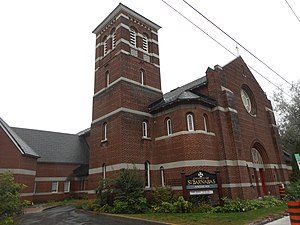
St. Barnabas, Apostle and Martyr Anglican Church is an Anglican church in the Anglo-Catholic tradition at 70 James Street (at Kent Street) in Ottawa, Ontario, Canada.
Canada Without Poverty
Not-for-profit organization in Canada
Distance: Approx. 522 meters
Latitude and longitude: 45.4151,-75.6943
Canada Without Poverty (CWP) is a not-for-profit organization dedicated to eradicating poverty in Canada and educating Canadians about the link between poverty and human rights. CWP is based in Ottawa, with a second office in Vancouver and is run by a board of directors who have, or have had, personal experiences of poverty. CWP campaigned for the development of consistent poverty indicators, which can be used to effectively help the estimated 1 in 15 (2.4 million) Canadians living in conditions of poverty.
Weather in this IP's area
mist
3 Celsius
-1 Celsius
2 Celsius
4 Celsius
999 hPa
96 %
999 hPa
990 hPa
2414 meters
6.17 m/s
80 degree
100 %


