199.91.224.239 - IP Lookup: Free IP Address Lookup, Postal Code Lookup, IP Location Lookup, IP ASN, Public IP
Country:
Region:
City:
Location:
Time Zone:
Postal Code:
IP information under different IP Channel
ip-api
Country
Region
City
ASN
Time Zone
ISP
Blacklist
Proxy
Latitude
Longitude
Postal
Route
Luminati
Country
ASN
Time Zone
America/Chicago
ISP
ALLCAREHEALTH
Latitude
Longitude
Postal
IPinfo
Country
Region
City
ASN
Time Zone
ISP
Blacklist
Proxy
Latitude
Longitude
Postal
Route
IP2Location
199.91.224.239Country
Region
oregon
City
grants pass
Time Zone
America/Los_Angeles
ISP
Language
User-Agent
Latitude
Longitude
Postal
db-ip
Country
Region
City
ASN
Time Zone
ISP
Blacklist
Proxy
Latitude
Longitude
Postal
Route
ipdata
Country
Region
City
ASN
Time Zone
ISP
Blacklist
Proxy
Latitude
Longitude
Postal
Route
Popular places and events near this IP address

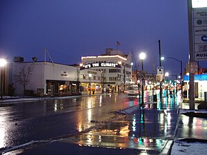
Grants Pass, Oregon
City in Oregon, United States
Distance: Approx. 3464 meters
Latitude and longitude: 42.43888889,-123.32833333
Grants Pass is a city in and the county seat of Josephine County, Oregon, United States. The city is located on Interstate 5, northwest of Medford, along the Rogue River. The population is 39,194 according to the 2020 census, making it the 15th most populous city in Oregon.
Grants Pass High School
Public school in Grants Pass, Oregon, United States
Distance: Approx. 3497 meters
Latitude and longitude: 42.444488,-123.317663
Grants Pass High School is a public high school located in Grants Pass, Oregon, United States. The school colors are blue and white, and the mascot is the Caveman. The mascot is a reference to the Oregon Caves National Monument, which is an important tourist attraction in nearby Cave Junction, Oregon.
KAJO
Radio station in Oregon, United States
Distance: Approx. 3264 meters
Latitude and longitude: 42.43777778,-123.3575
KAJO (1270 AM, "KAJO AM 1270 & 99.7 FM") is a commercial AC/classic hits and news/talk radio station in Grants Pass, Oregon, broadcasting to the Southern Oregon area. It is owned by Carl Wilson's Grants Pass Broadcasting Corporation.
KAGI
Radio station in Grants Pass, Oregon
Distance: Approx. 3264 meters
Latitude and longitude: 42.43777778,-123.3575
KAGI (930 AM) is a radio station in Grants Pass, Oregon, United States. The station is owned by Southern Oregon University and is part of its Jefferson Public Radio (JPR) network; it airs JPR's "News & Information" service, consisting of news and talk programming. While it principally broadcasts at 930 kHz on the AM band, a translator, K250BZ (97.9 FM), rebroadcasts its programming on the FM band in the Grants Pass area.

Grants Pass Supervisor's Warehouse
United States historic place
Distance: Approx. 3334 meters
Latitude and longitude: 42.437167,-123.338897
The Grants Pass Supervisor's Warehouse is a historic former national forest administrative facility in Grants Pass, Oregon, United States. The warehouse complex was listed on the National Register of Historic Places in 1991.

Redwoods Hotel
United States historic place
Distance: Approx. 3382 meters
Latitude and longitude: 42.44111111,-123.32527778
The Redwoods Hotel, also known as the Redwood Towers, is a historic six-story hotel building located at 306-310 Northwest 6th Street in Grants Pass, Josephine County, Oregon. Built in 1926 of reinforced concrete with cast concrete art deco ornamentation on its front facade, it was designed by the architectural firm of Tourtellotte and Hummel, noted for the many buildings it designed in Idaho and Oregon. Its builder was R.I. (Richard Irwin) Stuart, of Medford, Oregon, who completed it in 6 months.
Rogue River Valley Grange No. 469
United States historic place
Distance: Approx. 2875 meters
Latitude and longitude: 42.44055556,-123.35111111
Rogue River Valley Grange No. 469 was a historic Grange hall located at 2064 Upper River Road in Grants Pass, Oregon. It was built in 1923 in the bungalow craftsman style.
KJCR-LP
Radio station in Grants Pass, Oregon
Distance: Approx. 2625 meters
Latitude and longitude: 42.46294444,-123.37994444
KJCR-LP (107.9 FM) is a radio station licensed to Grants Pass, Oregon, United States. The station is owned by His Mercy Radio, Inc. It has been granted a U.S. Federal Communications Commission (FCC) construction permit to increase to 100 watts ERP and decrease HAAT to -134 meters.

Newman United Methodist Church
Historic church in Oregon, United States
Distance: Approx. 3261 meters
Latitude and longitude: 42.442944,-123.324336
The Newman United Methodist Church is a church and historic church building located in Grants Pass, Oregon, United States. The church was listed on the National Register of Historic Places in 1977.

Asante Three Rivers Medical Center
Hospital in Oregon, United States
Distance: Approx. 5006 meters
Latitude and longitude: 42.4215,-123.343
Asante Three Rivers Medical Center (TRMC; formerly known as Three Rivers Community Hospital, TRCH) is a 125-bed general acute care hospital located in Grants Pass in the U.S. state of Oregon. TRMC was built as a merger between two hospitals, Josephine Memorial (General) Hospital and Southern Oregon Medical Center in 2001.

John and Susanna Ahlf House
Historic house in Oregon, United States
Distance: Approx. 3062 meters
Latitude and longitude: 42.445578,-123.323789
The John and Susanna Ahlf House is a historic residence in Grants Pass, Oregon, United States. Built in 1902, it is the finest remaining example of the Queen Anne style in Grants Pass, and was the most prominent home in the city prior to World War I. It was built for John Ahlf (1856–1932), a German immigrant and meat packer who became one of the leading businessmen of the Rogue Valley. The house was added to the National Register of Historic Places in 1983.

Grants Pass City Hall and Fire Station
United States historic place
Distance: Approx. 3374 meters
Latitude and longitude: 42.43916667,-123.33
The Grants Pass City Hall and Fire Station, at 4th and H Streets in Grants Pass, Oregon, was built in 1912. It was listed on the National Register of Historic Places in 1984. It is a two-story brick building designed by Ashland architect W.F. Bowen.
Weather in this IP's area
fog
6 Celsius
2 Celsius
5 Celsius
7 Celsius
1016 hPa
88 %
1016 hPa
954 hPa
10000 meters
7.72 m/s
15.43 m/s
190 degree
100 %