Country:
 USA
USARegion:
City:
Latitude and Longitude:
Time Zone:
Postal Code:
IP information under different IP Channel
ip-api
Country
Region
City
ASN
Time Zone
ISP
Blacklist
Proxy
Latitude
Longitude
Postal
Route
IPinfo
Country
Region
City
ASN
Time Zone
ISP
Blacklist
Proxy
Latitude
Longitude
Postal
Route
MaxMind
Country
Region
City
ASN
Time Zone
ISP
Blacklist
Proxy
Latitude
Longitude
Postal
Route
Luminati
Country
USASN
Time Zone
America/Chicago
ISP
CROWNCASTLE-AS46887
Latitude
Longitude
Postal
db-ip
Country
Region
City
ASN
Time Zone
ISP
Blacklist
Proxy
Latitude
Longitude
Postal
Route
ipdata
Country
Region
City
ASN
Time Zone
ISP
Blacklist
Proxy
Latitude
Longitude
Postal
Route
Popular places and events near this IP address

Oakwood Memorial Park Cemetery
Cemetery in Los Angeles County, California
Distance: Approx. 2999 meters
Latitude and longitude: 34.253,-118.62
The Oakwood Memorial Park Cemetery is located at 22601 Lassen Street, Chatsworth, Los Angeles, California. It is the resting place for several movie stars such as Fred Astaire, Ginger Rogers, Gloria Grahame, and Stephen Boyd.
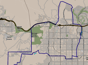
Chatsworth, Los Angeles
Neighborhood of Los Angeles in California, United States
Distance: Approx. 1534 meters
Latitude and longitude: 34.25722,-118.60028
Chatsworth is a suburban neighborhood in Los Angeles, California, in the San Fernando Valley. The area was home to Native Americans, who left caves containing rock art. Chatsworth was explored and colonized by the Spanish beginning in the 18th century.

Stoney Point (California)
Historic site in Los Angeles, California
Distance: Approx. 2935 meters
Latitude and longitude: 34.270929,-118.603522
Stoney Point, also known as the Stoney Point Outcroppings or Chatsworth Formation, is a Los Angeles City park near the north end of Topanga Canyon Boulevard (State Route 27) in Chatsworth, Los Angeles, California, part of the city of Los Angeles. Stoney Point is a popular destination for hikers, equestrians and also with rock climbers because of its large boulders, which afford many opportunities to practice the sport of bouldering. The top of the rock formation offers excellent views of Chatsworth, the Santa Susana Mountains, Coyote Pass, and the entire San Fernando Valley.

Chatsworth station
Transit hub in San Fernando Valley, Los Angeles, California
Distance: Approx. 1185 meters
Latitude and longitude: 34.25277778,-118.59944444
Chatsworth station (also known as Chatsworth Transportation Center) is an intermodal passenger transport station in the Los Angeles neighborhood of Chatsworth, United States. It is served by Amtrak Pacific Surfliner inter-city rail service, Metrolink Ventura County Line commuter rail service, and the Metro G Line of the Los Angeles Metro Busway bus rapid transit. The station is also served by Los Angeles Metro Bus and Simi Valley Transit local buses, plus Santa Clarita Transit and LADOT Commuter Express regional express bus routes.
Chatsworth Hills Academy
Independent, private, coeducational school in Chatsworth, California, United States
Distance: Approx. 2983 meters
Latitude and longitude: 34.2731,-118.59904
Chatsworth Hills Academy (CHA) is a private, coeducational day school located in Chatsworth, California, United States. CHA students are enrolled in Grades K through Eight and Preschool. CHA is accredited by the California Association of Independent Schools (CAIS) and the Western Association of Schools and Colleges (WASC).
Phillips Graduate University
Graduate school in Los Angeles, California
Distance: Approx. 1986 meters
Latitude and longitude: 34.242023,-118.567625
Phillips Graduate University was a private graduate school in Chatsworth, Los Angeles, with an administrative office in Sunnyvale, California. It provided numerous degrees including doctoral degrees in Business Administration, Psychology, Organizational Management & Consulting and master's degrees in family therapy, art therapy, and human relations.

Minnie Hill Palmer House
Historic house in California, United States
Distance: Approx. 2865 meters
Latitude and longitude: 34.26111111,-118.61472222
The Minnie Hill Palmer House, also known as The Homestead Acre, is the only remaining homestead cottage in the San Fernando Valley. The cottage is a redwood Stick-Eastlake style American Craftsman-Bungalow located on a 1.3-acre (0.53 ha) site in Chatsworth Park South in the Chatsworth section of Los Angeles, California.

2008 Chatsworth train collision
Head-on collision in Los Angeles, California
Distance: Approx. 2946 meters
Latitude and longitude: 34.27194444,-118.60138889
The 2008 Chatsworth train collision occurred at 4:22:23 p.m. PDT (23:22:23 UTC) on September 12, 2008, when a Union Pacific Railroad freight train and a Metrolink commuter rail passenger train collided head-on in the Chatsworth neighborhood of Los Angeles, California, United States. The scene of the collision was a curved section of single track on the Metrolink Ventura County Line just east of Stoney Point.
Chatsworth Community Church
Los Angeles Historic-Cultural Monument in California, U.S.
Distance: Approx. 3089 meters
Latitude and longitude: 34.25474,-118.62053
Chatsworth Community Church is a Los Angeles Historic-Cultural Monument in the Chatsworth section of Los Angeles, California.
Sierra Canyon School
Private preparatory school in Los Angeles, California
Distance: Approx. 2500 meters
Latitude and longitude: 34.2703,-118.5861
Sierra Canyon School (SCS) is a private, coeducational university-preparatory day school located in Los Angeles, California. Sierra Canyon enrolls students in preschool through grade 12. Sierra Canyon School is accredited by the California Association of Independent Schools (CAIS).
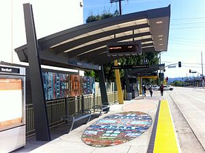
Nordhoff station
Bus rapid transit station in Los Angeles, California
Distance: Approx. 1604 meters
Latitude and longitude: 34.23554,-118.59696
Nordhoff station is a station on the G Line of the Los Angeles Metro Busway system located in the Chatsworth neighborhood of Los Angeles in the western San Fernando Valley. The station opened in June 2012 and was built as part of the Metro Orange Line Chatsworth Extension. Metro's Division 8 (West San Fernando Valley) bus depot is located directly west of the station.
Browns Creek Bike Path
Cycling route in California, USA
Distance: Approx. 988 meters
Latitude and longitude: 34.2501,-118.5984
Browns Creek Bike Path is a Class I bike path that is “tucked away from the surrounding hustle and bustle” of the San Fernando Valley, “hugging the side” of the Browns Canyon Wash. The path begins at Lassen Street, just east of Chatsworth Metrolink Station, and ends just north of Rinaldi Street near Stoney Point Park. Browns Creek (sometimes called Brown’s Creek), a tributary of the Los Angeles River, offers “splendid views of the irregularly shaped Santa Susana mountains rising to the west.” One local writer observed, “What [the concrete-lined creek] lacks in scenery, it compensates for by providing the trail with an open, airy setting.” The route has been described as “very rustic” (for an urban bike path, of course).
Weather in this IP's area
clear sky
30 Celsius
29 Celsius
25 Celsius
32 Celsius
1008 hPa
35 %
1008 hPa
977 hPa
10000 meters
0.89 m/s
2.24 m/s
1 degree
1 %
06:32:29
19:12:13