Country:
 USA
USARegion:
City:
Latitude and Longitude:
Time Zone:
Postal Code:
IP information under different IP Channel
ip-api
Country
Region
City
ASN
Time Zone
ISP
Blacklist
Proxy
Latitude
Longitude
Postal
Route
IPinfo
Country
Region
City
ASN
Time Zone
ISP
Blacklist
Proxy
Latitude
Longitude
Postal
Route
MaxMind
Country
Region
City
ASN
Time Zone
ISP
Blacklist
Proxy
Latitude
Longitude
Postal
Route
Luminati
Country
USRegion
ca
City
petaluma
ASN
Time Zone
America/Los_Angeles
ISP
MARIN-MIDAS
Latitude
Longitude
Postal
db-ip
Country
Region
City
ASN
Time Zone
ISP
Blacklist
Proxy
Latitude
Longitude
Postal
Route
ipdata
Country
Region
City
ASN
Time Zone
ISP
Blacklist
Proxy
Latitude
Longitude
Postal
Route
Popular places and events near this IP address

Mill Valley, California
City in California, United States
Distance: Approx. 1883 meters
Latitude and longitude: 37.90611111,-122.545
Mill Valley is a city in Marin County, California, United States, located about 14 miles (23 km) north of San Francisco via the Golden Gate Bridge and 52 miles (84 km) from Napa Valley. The population was 14,231 at the 2020 census. Mill Valley is located on the western and northern shores of Richardson Bay, and the eastern slopes of Mount Tamalpais.

Strawberry, Marin County, California
Census-designated place in California, United States
Distance: Approx. 1913 meters
Latitude and longitude: 37.89694444,-122.50888889
Strawberry is a census-designated place (CDP) and an unincorporated district of Marin County, California, United States. It shares a ZIP code (94941) with Mill Valley (hence, addresses in Strawberry are listed as "Mill Valley") and falls within its school districts; however, it is considered within the sphere of influence of the town of Tiburon. It is largely separated from Mill Valley by U.S. Route 101.
Tamalpais-Homestead Valley, California
Census-designated place in California, United States
Distance: Approx. 1163 meters
Latitude and longitude: 37.8962,-122.54318
Tamalpais-Homestead Valley is a census-designated place (CDP) in Marin County, California, United States. The population was 11,492 at the 2020 census.

Tamalpais High School
School in Mill Valley, California, United States
Distance: Approx. 193 meters
Latitude and longitude: 37.8921,-122.530751
Tamalpais High School (often abbreviated as Tam) is a public secondary school located in Mill Valley, California, in the San Francisco Bay Area. It is named after nearby Mount Tamalpais, which rises almost 2,500 feet (760 m) above Mill Valley. Tamalpais High School is the original campus of the Tamalpais Union High School District and the second public high school in Marin County.

2 AM Club
Distance: Approx. 702 meters
Latitude and longitude: 37.89709,-122.53712
The 2 AM Club is a bar in Mill Valley, California. The bar was the location for the cover photo of the Huey Lewis and the News' album Sports; Lewis himself attended school in Mill Valley. It is known locally as "The Deuce".
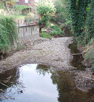
Arroyo Corte Madera del Presidio
River in California, United States
Distance: Approx. 674 meters
Latitude and longitude: 37.89083333,-122.52361111
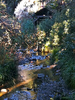
Arroyo Corte Madera del Presidio is a 4.1-mile-long (6.6 km) year-round stream in southern Marin County, California, United States. This watercourse is also known as Corte Madera Creek, although the actual stream of that name flows into San Francisco Bay further north at Point San Quentin. This watercourse has a catchment basin of about 8 square miles (21 km2) and drains the south-eastern slopes of Mount Tamalpais and much of the area in and around the town of Mill Valley; this stream discharges to Richardson Bay.
Marin Theatre Company
Distance: Approx. 644 meters
Latitude and longitude: 37.897297,-122.536137
Marin Theatre is a 501(c)3 nonprofit organization and professional LORT D regional theater located in Mill Valley, California. Lance Gardner is the company's Artistic Director Marin Theatre is home to the 231-seat Boyer Theatre and 99-seat Lieberman Studio Theatre. Notable past productions include the Bay Area premiere of Matthew Lopez's The Whipping Man, the 10th Anniversary revival of Suzan-Lori Parks's Pulitzer Prize for Drama-winning Topdog/Underdog, the Bay Area premiere of Annie Baker's Circle Mirror Transformation, the West Coast premiere of Keith Huff's A Steady Rain, the world premiere of Steve Yockey's Bellwether, the world premiere of Libby Appel's adaptation of Anton Chekhov's The Seagull, the world premiere of Bill Cain's 2011 Harold and Mimi Steinberg/American Theatre Critics Association New Play Award -winning 9 Circles, the West Coast premiere of Tarell Alvin McCraney's In the Red & Brown Water, and the Bay Area premiere of Bill Cain's 2010 Steinberg/ATCA New Play Award -winning Equivocation.
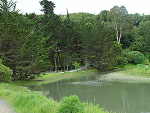
Bothin Marsh
Distance: Approx. 814 meters
Latitude and longitude: 37.888537,-122.523864
Bothin Marsh is a 106 acres (43 ha) wetland in Marin County, California. Parts of the wetlands are in the Bothin Marsh Open Space Preserve, a regional park.
Alto, California
Census-designated place in California, United States
Distance: Approx. 1256 meters
Latitude and longitude: 37.90444444,-122.52555556
Alto (Spanish for "Tall") is a census-designated place adjacent to Mill Valley in Marin County, California. It lies at an elevation of 26 feet (8 m). The population was 732 at the 2020 census.
Coyote Creek (Marin County)
River in California, United States
Distance: Approx. 1561 meters
Latitude and longitude: 37.88305556,-122.51888889
Coyote Creek is a stream in the Richardson Bay watershed, draining Tamalpais-Homestead Valley, California (Tam Valley) eastward into Richardson Bay, Marin County, California, United States. The stream originates on Coyote Ridge and flows 2.5 miles (4.0 km) to the bay at the south end of Bothin Marsh.

Silva Island
Island in California
Distance: Approx. 1516 meters
Latitude and longitude: 37.8875,-122.515
Silva Island (also De Silva Island) is an island in San Francisco Bay, formerly completely separated from the mainland but now mostly connected. It is in Marin County, California. Its coordinates are 37°53′15″N 122°30′54″W, and the United States Geological Survey gives its elevation as 79 ft (24 m).
Old Mill Creek (Arroyo Corte Madera del Presidio)
River in California, United States
Distance: Approx. 1916 meters
Latitude and longitude: 37.90520278,-122.54664444
Old Mill Creek is a 2.3-mile-long (3.7 km) year-round stream in southern Marin County, California, United States. Old Mill Creek is a tributary to Arroyo Corte Madera del Presidio, which, in turn, flows to Richardson Bay at Mill Valley's municipal Bayfront Park and 106 acres (0.43 km2) Bothin Marsh.
Weather in this IP's area
clear sky
14 Celsius
13 Celsius
12 Celsius
16 Celsius
1018 hPa
35 %
1018 hPa
1018 hPa
10000 meters
1.34 m/s
3.58 m/s
327 degree
07:21:53
18:28:05