Country:
Region:
City:
Latitude and Longitude:
Time Zone:
Postal Code:
IP information under different IP Channel
ip-api
Country
Region
City
ASN
Time Zone
ISP
Blacklist
Proxy
Latitude
Longitude
Postal
Route
Luminati
Country
ASN
Time Zone
America/Chicago
ISP
DATABANK-DFW
Latitude
Longitude
Postal
IPinfo
Country
Region
City
ASN
Time Zone
ISP
Blacklist
Proxy
Latitude
Longitude
Postal
Route
db-ip
Country
Region
City
ASN
Time Zone
ISP
Blacklist
Proxy
Latitude
Longitude
Postal
Route
ipdata
Country
Region
City
ASN
Time Zone
ISP
Blacklist
Proxy
Latitude
Longitude
Postal
Route
Popular places and events near this IP address

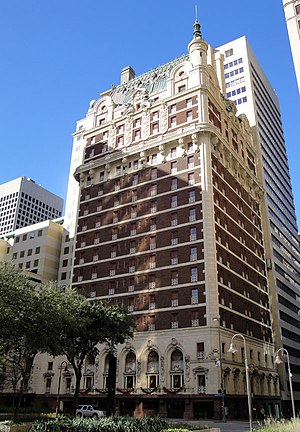
Adolphus Hotel
United States historic place
Distance: Approx. 174 meters
Latitude and longitude: 32.77972222,-96.79916667
The Adolphus Hotel is a historic upscale hotel established in 1912 in the Main Street District of Downtown Dallas, Texas. A Dallas Landmark, it was for several years the tallest building in the state. Today, the hotel is part of Marriott's Autograph Collection brand.

Magnolia Hotel (Dallas, Texas)
United States historic place
Distance: Approx. 195 meters
Latitude and longitude: 32.78,-96.79888889
The Magnolia Hotel (sometimes called the Magnolia Building, originally the Magnolia Petroleum Building) is a 29-story, Beaux-Arts style, upscale hotel in the Main Street District of downtown Dallas, Texas, that for many years was the tallest building in the state after surpassing the Adolphus Hotel. The structure is a Dallas Landmark and is listed on the National Register of Historic Places.

Government District, Dallas
Neighborhood in Dallas, Texas
Distance: Approx. 195 meters
Latitude and longitude: 32.777,-96.797
The Government District is an area in south-central downtown Dallas, Texas (USA). It lies south of the Main Street District, southeast of the West End Historic District, north of the Convention Center District, west of the Farmers Market District, and east of the Reunion District.

J. Erik Jonsson Central Library
Distance: Approx. 131 meters
Latitude and longitude: 32.778265,-96.797006
The J. Erik Jonsson Central Library is the main library of the Dallas Public Library system. It is located at 1515 Young Street in the Government District of downtown Dallas, Texas, directly across from Dallas City Hall.

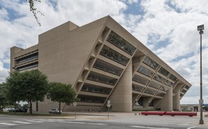
Dallas City Hall
Municipal Government in Dallas, TX
Distance: Approx. 272 meters
Latitude and longitude: 32.776236,-96.796838
Dallas City Hall is the seat of municipal government of the city of Dallas, Texas, United States. It is located at 1500 Marilla Street in the Government District of downtown Dallas. The current building, the city's fifth city hall, was completed in 1978 and replaced the Dallas Municipal Building.

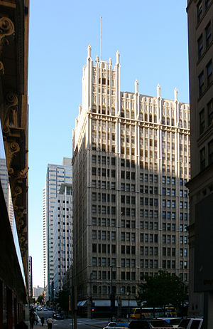
Kirby Building
United States historic place
Distance: Approx. 298 meters
Latitude and longitude: 32.78083333,-96.79944444
The Kirby Building, historically known as the Busch Building, is a 17-story skyscraper in the Main Street District of Downtown Dallas. The structure was completed in 1913 by beer magnate Adolphus Busch to accompany his nearby Hotel Adolphus. The building became vacant with many older buildings during the economic downturn of the 1980s.

Whitacre Tower
AT&T global headquarters and skyscraper in Dallas Texas
Distance: Approx. 135 meters
Latitude and longitude: 32.77944444,-96.79888889
Whitacre Tower, also known as One AT&T Plaza, and formerly known as One Bell Plaza, is a 37-story high-rise in Downtown Dallas, built adjacent to the Akard Street Mall in 1984. The building is the headquarters for AT&T and Southwestern Bell Telephone, which operates as "AT&T Southwest". It is 580 feet (177 m) tall, the 13th-tallest building in the city.

Pegasus Plaza
Distance: Approx. 253 meters
Latitude and longitude: 32.780448,-96.799299
Pegasus Plaza is a public park located in downtown Dallas, Texas. Located at the corner of Akard and Main Street in the Main Street District, the plaza takes its name from Pegasus, the iconic sign atop the adjacent Magnolia Hotel and the mythical flying horse. The shaded plaza includes several fountains and is used for concerts, festivals and Christmas celebrations.

Dallas Downtown Historic District
Historic district in Texas, United States
Distance: Approx. 196 meters
Latitude and longitude: 32.77909,-96.80027
The Dallas Downtown Historic District is a 555-acre (225 ha) area in downtown Dallas, Texas, United States that was designated a historic district in 2006 and expanded in 2009 to preserve the diverse architectural history of the area.

Neiman Marcus Building
Distance: Approx. 276 meters
Latitude and longitude: 32.780637,-96.797416
The Neiman Marcus Building is a historic commercial structure located in the Main Street District in downtown Dallas, Texas (USA). It is the corporate headquarters and flagship store of Neiman Marcus. It is the last of the original department stores still serving downtown Dallas.

Baker Hotel (Dallas)
Hotel in Dallas, Texas, U.S.
Distance: Approx. 211 meters
Latitude and longitude: 32.77999,-96.79941
The Baker Hotel was a former grand hotel located in the heart of downtown, Dallas, Texas, across the landmark Adolphus Hotel and the Magnolia Hotel. Its interiors were remodeled in 1972 after a fire, and was imploded in 1980 to make way for the Whitacre Tower, which occupies its site today.

Lynching of Allen Brooks
1910 mob lynching in Dallas, Texas, U.S.
Distance: Approx. 263 meters
Latitude and longitude: 32.7805,-96.79941667
Allen Brooks was a black American man who was lynched by a mob on March 3, 1910, in Dallas, Texas. Brooks had been accused of raping a young white girl, and on the day he was set to face trial at the Dallas County Courthouse, a large mob pulled him by rope out of a second-story window at the courthouse, dragged him to Elks Arch, and hanged him from a telephone pole. The site of Brooks' lynching was unmarked for 111 years until a nonprofit placed a historical marker in 2021.
Weather in this IP's area
light rain
16 Celsius
17 Celsius
15 Celsius
18 Celsius
1016 hPa
93 %
1016 hPa
1000 hPa
10000 meters
4.12 m/s
310 degree
100 %
06:51:34
17:30:27