Country:
Region:
City:
Latitude and Longitude:
Time Zone:
Postal Code:
IP information under different IP Channel
ip-api
Country
Region
City
ASN
Time Zone
ISP
Blacklist
Proxy
Latitude
Longitude
Postal
Route
Luminati
Country
Region
tx
City
texarkana
ASN
Time Zone
America/Chicago
ISP
TAMUT-MAIN
Latitude
Longitude
Postal
IPinfo
Country
Region
City
ASN
Time Zone
ISP
Blacklist
Proxy
Latitude
Longitude
Postal
Route
db-ip
Country
Region
City
ASN
Time Zone
ISP
Blacklist
Proxy
Latitude
Longitude
Postal
Route
ipdata
Country
Region
City
ASN
Time Zone
ISP
Blacklist
Proxy
Latitude
Longitude
Postal
Route
Popular places and events near this IP address

Texarkana, Texas
City in Bowie County, Texas, United States
Distance: Approx. 3531 meters
Latitude and longitude: 33.47611111,-94.10833333
Texarkana is a city in Bowie County, Texas, United States, in the Ark-La-Tex region. Located approximately 180 miles (290 km) from Dallas, Texarkana is a twin city with neighboring Texarkana, Arkansas. The Texas city's population was 36,193 at the 2020 census.
Texas A&M University–Texarkana
Public university in Texarkana, Texas, U.S.
Distance: Approx. 2645 meters
Latitude and longitude: 33.4911,-94.0967
Texas A&M University–Texarkana (A&M–Texarkana) is a public university in Texarkana, Texas, United States. It is part of the Texas A&M University System. Students who reside in Oklahoma and Arkansas attend at in-state tuition rates, and historically 30 percent of the student body is from Arkansas.

Texarkana metropolitan area
Metropolitan Statistical Area in the United States
Distance: Approx. 4905 meters
Latitude and longitude: 33.43722222,-94.0675
The Texarkana metropolitan statistical area (MSA), as defined by the United States Office of Management and Budget, is a two-county region anchored by the twin cities of Texarkana, Texas (population 37,333) and Texarkana, Arkansas (population 30,259), and encompassing surrounding communities in Bowie County, Texas, and Miller County, Arkansas. As of the 2016 census, the MSA had a population of 150,098. Texarkana is a subset of the broader Ark-La-Tex region.
Texarkana College
Community college in Texarkana, Texas, US
Distance: Approx. 4200 meters
Latitude and longitude: 33.44388889,-94.0775
Texarkana College is a public community college in Texarkana, Texas.

Texas High School
Public high school in Texarkana, Texas, United States
Distance: Approx. 2920 meters
Latitude and longitude: 33.455351,-94.06543
Texas High School (THS) is a public high school in Texarkana, Texas, United States. It is part of the Texarkana Independent School District and is classified as a 5A school by the University Interscholastic League. For the 2021–2022 school year, the school was given a "B" by the Texas Education Agency.
Central Mall (Texarkana)
Shopping mall in Texas, U.S.
Distance: Approx. 2997 meters
Latitude and longitude: 33.4555,-94.0804
Central Mall is an enclosed shopping mall located in Texarkana, Texas. Opened in 1978, the anchor stores are Dillard's and JCPenney.
Beech Street Brick Street
United States historic place
Distance: Approx. 4789 meters
Latitude and longitude: 33.44722222,-94.03916667
The Beech Street Brick Street is an historic section of the Beech Street roadway in Texarkana, Arkansas. It consists of a section of road, between 14th and 24th Streets, which was paved in brick c. 1904.
Pleasant Grove High School (Texas)
Public high school in Texarkana, Bowie, Texas, United States
Distance: Approx. 3937 meters
Latitude and longitude: 33.466689,-94.10947
Pleasant Grove High School is a public high school located in Texarkana, Texas (United States). It is the sole high school in the Pleasant Grove Independent School District and is classified as a 4A school by the UIL. For the 2021-2022 school year, the school was given an "A" by the Texas Education Agency.

Wagner Creek (Texas)
Creek in eastern Texas
Distance: Approx. 4919 meters
Latitude and longitude: 33.464,-94.1196
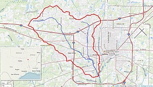
Wagner Creek is a creek in Bowie County, Texas. The creek rises north of Nash and flows south-east, under several major highways including I-30, U.S. Route 82, I-369, before meeting Days Creek in southern Texarkana. Cowhorn Creek flows into the creek to the south of U.S. Route 67.
Cowhorn Creek
Creek in eastern Texas
Distance: Approx. 3487 meters
Latitude and longitude: 33.456,-94.0931
Cowhorn Creek is a creek in Bowie County, Texas. The creek rises in northeastern Texarkana and flows south, under several major highways including U.S. Route 82 and U.S. Route 67 before meeting Wagner Creek to the south of the city.
Swampoodle Creek
Creek in eastern Texas
Distance: Approx. 4214 meters
Latitude and longitude: 33.4455,-94.0557
Swampoodle Creek is a creek in Bowie County, Texas. The creek rises in northern Texarkana and flows south, under several major highways including U.S. Route 82 and U.S. Route 67 before meeting Days Creek, alongside Nix Creek near the Arkansas border.
Nix Creek
Creek in western Arkansas
Distance: Approx. 5067 meters
Latitude and longitude: 33.4605,-94.0222
Nix Creek is a creek in the Texarkana metropolitan area. The creek is mainly situated in Texarkana, Arkansas, but briefly crosses the border into Texarkana, Texas where it meets Days Creek alongside Swampoodle Creek. The creek passes under U.S. Route 82.
Weather in this IP's area
overcast clouds
16 Celsius
16 Celsius
16 Celsius
17 Celsius
1014 hPa
71 %
1014 hPa
1001 hPa
10000 meters
3.6 m/s
130 degree
100 %
06:49:21
17:13:14
