199.79.251.33 - IP Lookup: Free IP Address Lookup, Postal Code Lookup, IP Location Lookup, IP ASN, Public IP
Country:
Region:
City:
Location:
Time Zone:
Postal Code:
ISP:
ASN:
language:
User-Agent:
Proxy IP:
Blacklist:
IP information under different IP Channel
ip-api
Country
Region
City
ASN
Time Zone
ISP
Blacklist
Proxy
Latitude
Longitude
Postal
Route
db-ip
Country
Region
City
ASN
Time Zone
ISP
Blacklist
Proxy
Latitude
Longitude
Postal
Route
IPinfo
Country
Region
City
ASN
Time Zone
ISP
Blacklist
Proxy
Latitude
Longitude
Postal
Route
IP2Location
199.79.251.33Country
Region
south carolina
City
rock hill
Time Zone
America/New_York
ISP
Language
User-Agent
Latitude
Longitude
Postal
ipdata
Country
Region
City
ASN
Time Zone
ISP
Blacklist
Proxy
Latitude
Longitude
Postal
Route
Popular places and events near this IP address
South Pointe High School (Rock Hill, South Carolina)
Public high school in Rock Hill, South Carolina, United States
Distance: Approx. 3470 meters
Latitude and longitude: 34.8881,-81.0606
South Pointe High School is the third and newest high school in Rock Hill, South Carolina, USA. The school is part of York County School District Three (Rock Hill Schools). It has an enrollment of approximately 1,196 students in grades 9–12.

First Presbyterian Church (Rock Hill, South Carolina)
Historic church in South Carolina, United States
Distance: Approx. 3894 meters
Latitude and longitude: 34.92361111,-81.02527778
First Presbyterian Church is a historic church at 234 E. Main Street in Rock Hill, South Carolina. It was designed by Charles Coker Wilson and was built in 1894. It was added to the National Register in 1992.
Hermon Presbyterian Church
Historic church in South Carolina, United States
Distance: Approx. 3997 meters
Latitude and longitude: 34.92333333,-81.03416667
Hermon Presbyterian Church is a historic church at 446 Dave Lyle Boulevard in Rock Hill, South Carolina. It was built in 1897 and added to the National Register of Historic Places in 1992.

United States Post Office and Courthouse (Rock Hill, South Carolina)
United States historic place
Distance: Approx. 4052 meters
Latitude and longitude: 34.925,-81.02583333
The U.S. Post Office and Courthouse in Rock Hill, South Carolina, also known as Caldwell Street Post Office, was built in 1931. It served historically as a courthouse and as a post office, and is currently in use as the Gettys Art Center. It was listed on the National Register of Historic Places in 1988.
Oakdale, South Carolina
Neighborhood in York, South Carolina, United States
Distance: Approx. 2767 meters
Latitude and longitude: 34.88027778,-81.05111111
Oakdale is a neighborhood of Rock Hill that was annexed into the city in the early 1980s. Oakdale is located at latitude 34.88 and longitude -81.051. The elevation of the neighborhood is 640 feet.
Clinton College (South Carolina)
Christian college in South Carolina, U.S.
Distance: Approx. 3372 meters
Latitude and longitude: 34.91361111,-81.04361111
Clinton College is a private historically black Christian college in Rock Hill, South Carolina. It is accredited by the Transnational Association of Christian Colleges and Schools.

Rock Hill Downtown Historic District
Historic church in South Carolina, United States
Distance: Approx. 4078 meters
Latitude and longitude: 34.92527778,-81.025
Rock Hill Downtown Historic District consists of twelve contiguous buildings built between 1870 and 1931 in downtown Rock Hill in York County, South Carolina. The twelve buildings are: Episcopal Church of Our Saviour, 144 Caldwell St. First Associate Reformed Presbyterian Church, 201 E. White St.

Afro-American Insurance Company Building
United States historic place
Distance: Approx. 3893 meters
Latitude and longitude: 34.92194444,-81.03583333
Afro-American Insurance Company Building is a historic commercial building located at Rock Hill, South Carolina. It was built about 1909, and is a two-story, brick commercial building. The façade has a tan brick veneer, while the sides and rear are in red brick.

People's National Bank Building (Rock Hill, South Carolina)
United States historic place
Distance: Approx. 4122 meters
Latitude and longitude: 34.92555556,-81.02694444
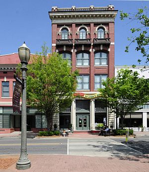
People's National Bank Building, also known as Franklin's Clothing Store, is a historic bank building located at Rock Hill, South Carolina. It was built about 1909–1910, and is a four-story brick building, plus basement. It was the first building in the city constructed as a speculative office building, the first with a passenger elevator, and the tallest commercial building in Rock Hill.

Marion Street Area Historic District
Historic district in South Carolina, United States
Distance: Approx. 3558 meters
Latitude and longitude: 34.92027778,-81.02861111
Marion Street Area Historic District is a national historic district in Rock Hill, South Carolina. It encompasses 28 contributing buildings and 1 contributing site in a middle-class residential section of Rock Hill. The bulk of the district developed between 1906 and 1925.

Reid Street–North Confederate Avenue Area Historic District
Historic district in South Carolina, United States
Distance: Approx. 3918 meters
Latitude and longitude: 34.92388889,-81.02194444
Reid Street–North Confederate Avenue Area Historic District is a national historic district located at Rock Hill, South Carolina. It encompasses 22 contributing buildings in a middle-class residential section of Rock Hill. The district developed between about 1839 and 1935.

Highland Park Manufacturing Plant and Cotton Oil Complex
Historic district in South Carolina, United States
Distance: Approx. 3714 meters
Latitude and longitude: 34.92083333,-81.01166667
Highland Park Manufacturing Plant and Cotton Oil Complex is a historic industrial complex and national historic district located at Rock Hill, South Carolina. It encompasses three contributing building and two contributing structures in Rock Hill. The complex includes the Highland Park Manufacturing Plant (1888–89, 1907), the Highland Park Cotton Oil Mill (1902), and the Highland Park Cotton Oil Mill Office (1902).
Weather in this IP's area
clear sky
-3 Celsius
-6 Celsius
-4 Celsius
-3 Celsius
1031 hPa
43 %
1031 hPa
1008 hPa
10000 meters
1.54 m/s
360 degree
