Country:
 USA
USARegion:
City:
Latitude and Longitude:
Time Zone:
Postal Code:
IP information under different IP Channel
ip-api
Country
Region
City
ASN
Time Zone
ISP
Blacklist
Proxy
Latitude
Longitude
Postal
Route
IPinfo
Country
Region
City
ASN
Time Zone
ISP
Blacklist
Proxy
Latitude
Longitude
Postal
Route
MaxMind
Country
Region
City
ASN
Time Zone
ISP
Blacklist
Proxy
Latitude
Longitude
Postal
Route
Luminati
Country
USASN
Time Zone
America/Chicago
ISP
BUNNY-COMMUNICATIONS-GLOBAL
Latitude
Longitude
Postal
db-ip
Country
Region
City
ASN
Time Zone
ISP
Blacklist
Proxy
Latitude
Longitude
Postal
Route
ipdata
Country
Region
City
ASN
Time Zone
ISP
Blacklist
Proxy
Latitude
Longitude
Postal
Route
Popular places and events near this IP address

Metairie, Louisiana
Census-designated place in Louisiana, United States
Distance: Approx. 2287 meters
Latitude and longitude: 29.99777778,-90.1775
Metairie ( MET-ər-ee) is an unincorporated community and census-designated place (CDP) in Jefferson Parish, Louisiana, United States, and is part of the New Orleans metropolitan area. With a population of 143,507 in 2020, Metairie is the largest community in Jefferson Parish and was (as of 2010) the fifth-largest CDP in the United States. It is an unincorporated area that (as of 2020) would have been Louisiana's fourth-largest city behind Shreveport if incorporated.

Shrewsbury, Louisiana
Unincorporated Louisiana town
Distance: Approx. 2603 meters
Latitude and longitude: 29.97111111,-90.14222222
Shrewsbury is an unincorporated community in Jefferson Parish, Louisiana, United States, along the Mississippi River and Shrewsbury Road about 1 mile upriver from the border of the city of New Orleans. The name came into use in the mid-19th century, and became less commonly used towards the end of the 20th century, when surrounding communities of unincorporated Jefferson grew together as a suburb of New Orleans. The area is now generally known as Old Jefferson and is part of the Greater New Orleans Metropolitan area.

Grace King High School
Public school in Metairie, Louisiana, United States
Distance: Approx. 2595 meters
Latitude and longitude: 30.013,-90.166
Grace King High School was a public high school located in Metairie, unincorporated Jefferson Parish, Louisiana, United States. It was a part of the Jefferson Parish Public Schools and served portions of Metairie and Kenner.
Ridgewood Preparatory School
Private school in Metairie, Louisiana, U.S.
Distance: Approx. 2450 meters
Latitude and longitude: 29.97625,-90.17277778
Ridgewood Preparatory School was a university-preparatory private school located in Metairie, an unincorporated community in Jefferson Parish, Louisiana. It included grades PreK-12, with a student-teacher ratio of 10:1. Ridgewood was approved by the State Department of Education and accredited by the Southern Association of Colleges and Schools.

Archbishop Rummel High School
Private school in Metairie, Louisiana, United States
Distance: Approx. 491 meters
Latitude and longitude: 29.99,-90.15944444
Archbishop Rummel High School is a Catholic, Lasallian secondary school for boys located in Metairie, a community in unincorporated Jefferson Parish, Louisiana. The school is named after Archbishop Joseph Rummel, a former Archbishop in the Archdiocese of New Orleans.
Shrewsbury (Camp Parapet) Cemetery
Civil War era military camp and cemetery in Louisiana
Distance: Approx. 2492 meters
Latitude and longitude: 29.96953,-90.15745
Shrewsbury Cemetery, historically known as Camp Parapet Cemetery , is an old burial ground near New Orleans, Louisiana, on the site of a Confederate military camp during the American Civil War. The cemetery is the burying ground of Ross Church and First Zion Church, both located nearby. It is also sometimes known as First Zion Cemetery.
Lakeside Shopping Center
Shopping mall in Louisiana, U.S.
Distance: Approx. 1641 meters
Latitude and longitude: 30.00638889,-90.15722222
Lakeside Shopping Center, or simply Lakeside, is a shopping mall located at 3301 Veterans Memorial Boulevard in the New Orleans suburb of Metairie, Louisiana, United States. It opened on March 24, 1960 as the first regional shopping mall in New Orleans and is the largest and busiest mall in Greater New Orleans. Lakeside is a 967,000 sq ft (89,800 m2) mall with five major retail anchors (Apple Store, Dillard's, Macy's, JCPenney, and Zara).

The Galleria (Metairie, Louisiana)
Office in LA, U.S.
Distance: Approx. 493 meters
Latitude and longitude: 29.99555,-90.15207
The Galleria, located at One Galleria Boulevard in Metairie, Louisiana, is a 21-story, 269-foot (82 m)-tall skyscraper designed by architect HKS, Inc. The Galleria was completed in 1986 and is the second tallest building in Jefferson Parish. The tower's primary use is as office space, along with the studios of Nexstar Media Groups two television stations for the New Orleans market, ABC affiliate WGNO and CW affiliate WNOL-TV. Six towers of roughly equal height were originally planned; this tower is the only one that was built.
Pontiff Playground
Distance: Approx. 2038 meters
Latitude and longitude: 29.979075,-90.139604
Wally Pontiff Jr. Playground, formerly Metairie Playground, is a Jefferson Parish public playground located at 1521 Palm Street in Metairie, Louisiana. It is Jefferson Parish's oldest public playground.
Metairie Park Country Day School
School in Metairie, Louisiana, United States
Distance: Approx. 2411 meters
Latitude and longitude: 29.9825,-90.13222222
Metairie Park Country Day School is a private, nondenominational, co-educational college preparatory school in Metairie, Louisiana, with classes in grades Pre-Kindergarten–12. The 15-acre (6.1 ha) campus is located in the Old Metairie section of Metairie, Louisiana.
St. Christopher's School (Metairie, Louisiana)
School in Metairie, Louisiana, United States
Distance: Approx. 2251 meters
Latitude and longitude: 29.97666667,-90.17027778
Saint Christopher School is an elementary school located in Metairie, Louisiana. The school teaches children from kindergarten to seventh grade. Saint Christopher is recognized by the United States Department of Education as a National School of Excellence and was named a Blue Ribbon School for the 1993–1994 school year.
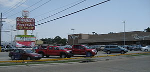
Dorignac's Food Center
Supermarkets of the United States
Distance: Approx. 2589 meters
Latitude and longitude: 30.00055,-90.12992
Dorignac's Food Center is a historic food store on Veterans Memorial Boulevard in Metairie, Louisiana, near New Orleans, known for offering regional specialties.
Weather in this IP's area
few clouds
26 Celsius
25 Celsius
24 Celsius
27 Celsius
1024 hPa
50 %
1024 hPa
1024 hPa
10000 meters
3.6 m/s
360 degree
20 %
07:05:59
18:24:19