Country:
Region:
City:
Latitude and Longitude:
Time Zone:
Postal Code:
IP information under different IP Channel
ip-api
Country
Region
City
ASN
Time Zone
ISP
Blacklist
Proxy
Latitude
Longitude
Postal
Route
Luminati
Country
Region
ga
City
villarica
ASN
Time Zone
America/New_York
ISP
FOGODC
Latitude
Longitude
Postal
IPinfo
Country
Region
City
ASN
Time Zone
ISP
Blacklist
Proxy
Latitude
Longitude
Postal
Route
db-ip
Country
Region
City
ASN
Time Zone
ISP
Blacklist
Proxy
Latitude
Longitude
Postal
Route
ipdata
Country
Region
City
ASN
Time Zone
ISP
Blacklist
Proxy
Latitude
Longitude
Postal
Route
Popular places and events near this IP address

New Orleans Central Business District
Neighborhood of New Orleans, United States
Distance: Approx. 178 meters
Latitude and longitude: 29.94972222,-90.07055556
The Central Business District (CBD) is a neighborhood of the city of New Orleans, Louisiana, United States. The CBD is a subdistrict of the French Quarter/CBD area. Its boundaries, as defined by the City Planning Commission are Iberville, Decatur and Canal Streets to the north; the Mississippi River to the east; the New Orleans Morial Convention Center, Julia and Magazine Streets, and the Pontchartrain Expressway to the south; and South Claiborne Avenue, Cleveland Street, as well as South and North Derbigny Streets to the west.

New Orleans Cotton Exchange
United States historic place
Distance: Approx. 90 meters
Latitude and longitude: 29.95188611,-90.07130278
The New Orleans Cotton Exchange was established in New Orleans, Louisiana, in 1871 as a centralized forum for the trade of cotton. It operated in New Orleans until closing in 1964. Occupying several buildings over its history, its final location, the New Orleans Cotton Exchange Building, is now a National Historic Landmark.

Hancock Whitney Center
Tallest building in both the city of New Orleans and the state of Louisiana
Distance: Approx. 107 meters
Latitude and longitude: 29.9502,-90.0711
Hancock Whitney Center, formerly One Shell Square, is a 51-story, 697-foot (212 m) skyscraper designed in the International style by Skidmore, Owings and Merrill, located at 701 Poydras Street in the Central Business District of New Orleans, Louisiana. It is the tallest building in both the city of New Orleans and the state of Louisiana, and is taller than Louisiana's tallest peak, Driskill Mountain. The building is primarily used for leasable office space, with some retail space on the ground level.

Place St. Charles
Skyscraper in New Orleans, Louisiana, US
Distance: Approx. 131 meters
Latitude and longitude: 29.95194444,-90.07055556
Place St. Charles (formerly the Bank One Center and First NBC Center), located at 201 St. Charles Avenue in the Central Business District of New Orleans, Louisiana, is a 53-story, 645-foot (197 m) skyscraper designed in the post-modern style by Moriyama & Teshima Architects with The Mathes Group, now Mathes Brierre Architects, as local architect.
Hibernia Bank Building (New Orleans)
Office in New Orleans, Louisiana
Distance: Approx. 62 meters
Latitude and longitude: 29.951653,-90.071435
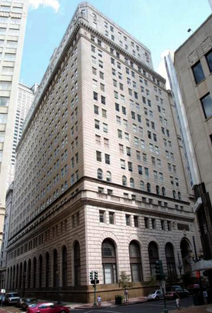
Hibernia Bank Building, at 812 Gravier Street at the corner of Carondelet Street in the Central Business District of New Orleans, Louisiana, is a 23-story, 355 feet (108 m)-tall skyscraper. It was once the headquarters of Hibernia National Bank. At the time it was completed in 1921, it was the tallest building in Louisiana.
National American Bank Building
United States historic place
Distance: Approx. 155 meters
Latitude and longitude: 29.95222222,-90.07055556
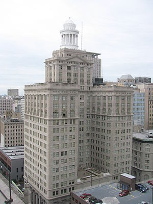
National American Bank Building is a 23-story 325 feet (99 m)-tall skyscraper in the Central Business District of New Orleans, Louisiana, It was completed in 1929 and listed on the National Register of Historic Places in 1986. It is topped with a distinctive 6-story octagonal tower with a golden Art Deco finial. Its address is 200 Carondelet Street.

Hilton New Orleans/St. Charles Avenue
American hotel skyscraper
Distance: Approx. 120 meters
Latitude and longitude: 29.950624,-90.070381
Hilton New Orleans/St. Charles Avenue, located at 333 St. Charles Avenue in the Central Business District of New Orleans, Louisiana, USA, is a 20-story, 246 feet (75 m)-tall skyscraper and part of the Hilton Hotels chain.

Hennen Building
Skyscraper in New Orleans, Louisiana
Distance: Approx. 156 meters
Latitude and longitude: 29.9525,-90.07138889
The Hennen Building, also known as the Canal-Commercial Building, Maritime Building, and briefly the Latter & Blum Building, is an 11-story, 158 feet (48 m)-tall skyscraper in New Orleans, Louisiana USA. Individually listed on the National Register of Historic Places (NRHP), the building is located at 800 Common Street at the uptown lake corner with Carondelet Street. It is also NRHP-listed as a contributing building in New Orleans' Central Business District. The building is New Orleans' first and oldest skyscraper, holding the title of the city's tallest building from 1895-1904.
Theatre de la Rue Saint Pierre
Former theater in New Orleans, Louisiana
Distance: Approx. 190 meters
Latitude and longitude: 29.95,-90.07
Theatre de la Rue Saint Pierre or Le Spectacle de la Rue Saint Pierre, was the first (French-speaking) theatre in New Orleans in Louisiana, active in 1792-1810. It opened in 1792 and was known to the Spanish-speaking citizens as El Coliseo and to the French-speaking citizens, La Salle Comedie. It was described as a small building of native lumber near the center of the city.
Le Pavillon Hotel
Distance: Approx. 148 meters
Latitude and longitude: 29.9504,-90.0728
The Le Pavillon Hotel is a historic hotel in New Orleans, Louisiana.

Four Winds (New Orleans)
Residential / Commercial in Louisiana, United States
Distance: Approx. 199 meters
Latitude and longitude: 29.952871,-90.071797
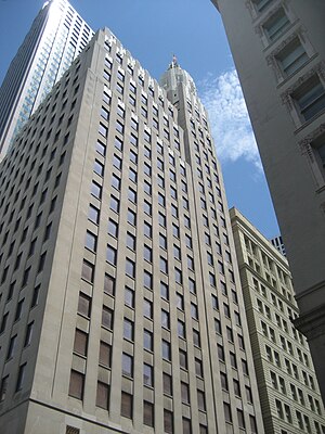
The Four Winds is a combination commercial and luxury apartment building in the Central Business District of New Orleans, Louisiana, developed by Kailas Companies. The building is 252-foot (77 m) high, and has nineteen floors. It was designed by Emile Weil, completed in 1927 and housed the Canal Bank and Trust.
NOPSI New Orleans
United States historic place
Distance: Approx. 175 meters
Latitude and longitude: 29.9521,-90.0729
NOPSI New Orleans, or the NOPSI Hotel, is a hotel in the historic NOPSI building in downtown New Orleans, Louisiana. The building is the former headquarters of New Orleans' main utilities company, the New Orleans Public Service Incorporated, which was set up in 1922 to consolidate numerous separate public utilities firms. Its nine-story building was designed by architects Favrot and Livaudais, and was constructed in 1927.
Weather in this IP's area
broken clouds
23 Celsius
24 Celsius
22 Celsius
24 Celsius
1012 hPa
86 %
1012 hPa
1012 hPa
10000 meters
0.45 m/s
1.34 m/s
131 degree
58 %
06:18:24
17:09:30


