Country:
Region:
City:
Latitude and Longitude:
Time Zone:
Postal Code:
IP information under different IP Channel
ip-api
Country
Region
City
ASN
Time Zone
ISP
Blacklist
Proxy
Latitude
Longitude
Postal
Route
Luminati
Country
Region
ga
City
villarica
ASN
Time Zone
America/New_York
ISP
FOGODC
Latitude
Longitude
Postal
IPinfo
Country
Region
City
ASN
Time Zone
ISP
Blacklist
Proxy
Latitude
Longitude
Postal
Route
db-ip
Country
Region
City
ASN
Time Zone
ISP
Blacklist
Proxy
Latitude
Longitude
Postal
Route
ipdata
Country
Region
City
ASN
Time Zone
ISP
Blacklist
Proxy
Latitude
Longitude
Postal
Route
Popular places and events near this IP address

Roswell, Georgia
City in Georgia, United States
Distance: Approx. 2510 meters
Latitude and longitude: 34.03916667,-84.35138889
Roswell is a city in northern Fulton County, Georgia, United States. At the official 2020 census, the city had a population of 92,883, making Roswell the state's ninth largest city. A suburb of Atlanta, Roswell has an affluent historic district.

Blessed Trinity Catholic High School
Archdiocesan Catholic high school in Roswell, Georgia, United States
Distance: Approx. 3261 meters
Latitude and longitude: 34.05583333,-84.38694444
Blessed Trinity Catholic High School, also known as Blessed Trinity or, informally BT, is an Archdiocesan Catholic high school in Roswell, Georgia, United States, a northern suburb of Atlanta. The multi-level curriculum provides Advanced Placement, Honors, Advanced, and Academic classes to fit the needs of each student. The curriculum grew over the first four years to over 130 courses, including 20 Advanced Placement offerings.

Roswell High School (Georgia)
Public high school in Roswell, Georgia, United States
Distance: Approx. 2674 meters
Latitude and longitude: 34.06272,-84.38127
Roswell High School (RHS) is a public high school in Roswell, Georgia, United States which opened in 1949. It serves the entire city of Roswell west of Georgia State Route 400 and the city of Mountain Park, as well as small portions of Alpharetta and Milton. Roswell High School neighbors both Fellowship Christian School and Blessed Trinity Catholic High School.

Area code 770
Area code in Georgia, United States
Distance: Approx. 2715 meters
Latitude and longitude: 34.03853,-84.34311
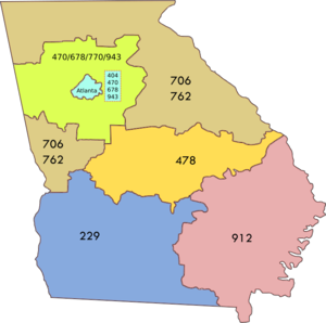
Area code 770 is a telephone area code in the North American Numbering Plan (NANP) serving all or part of 29 counties in North Georgia, including most of Atlanta's suburbs. It was created in 1995 in a split of numbering plan area (NPA) 404.

Archibald Smith Plantation Home
Historic house in Georgia, United States
Distance: Approx. 4269 meters
Latitude and longitude: 34.02388889,-84.36
The Archibald Smith Plantation Home is a historic house in Roswell, Georgia, built in 1845. The home was built by one of Roswell's founders, Archibald Smith, and housed three generations of his family.
Crabapple, Georgia
Distance: Approx. 3394 meters
Latitude and longitude: 34.09,-84.33861111
Centered today at the crossroads of Georgia Highways 140 and 372 (also known as "the Silos area"), Crabapple, Georgia, is one of the oldest parts of Fulton County, Georgia. Originally part of Cherokee County, Georgia, (created 1832), Crabapple was part of the land contributed in 1857 to form Milton County, Georgia. The first permanent settlement at Crabapple was made in 1874, with the community taking its name from a crabapple tree near the original town site.

Ameris Bank Amphitheatre
Amphitheater in Georgia, USA
Distance: Approx. 4251 meters
Latitude and longitude: 34.054499,-84.307033
The Ameris Bank Amphitheatre (formerly Verizon Amphitheatre) is a contemporary amphitheatre, located in the northern Atlanta suburb of Alpharetta, Georgia, United States. The amphitheatre mainly hosts shows by popular music artists, comedians and themed symphony concerts by the Atlanta Symphony Orchestra, the latter opened the venue with a performance on May 10, 2008. The venue opened as Verizon Wireless Amphitheatre at Encore Park in 2008.
Foe Killer Creek
Stream in Fulton County, Georgia, USA
Distance: Approx. 2288 meters
Latitude and longitude: 34.05638889,-84.32833333
Foe Killer Creek is a stream located in Fulton County, Georgia

Fellowship Christian School
Private christian school in Roswell, Georgia, United States
Distance: Approx. 2425 meters
Latitude and longitude: 34.05111111,-84.37527778
Fellowship Christian School is a private Christian school in Roswell, Georgia. It is located on Woodstock Road off of Georgia State Route 92. Neighboring Fellowship Christian are Roswell High School and Blessed Trinity Catholic High School.
Roswell Mall
Shopping center in Roswell, Georgia, US
Distance: Approx. 2846 meters
Latitude and longitude: 34.03805556,-84.34055556
Roswell Town Center, formerly Roswell Mall, is a shopping center located in Roswell, Georgia, built in 1974. It is situated at the intersection of Holcomb Bridge Road and Alpharetta Highway. This mall is not to be confused with the bigger, newer North Point Mall in Alpharetta, Georgia.

Computer Museum of America
Computer museum in Roswell, Georgia
Distance: Approx. 2763 meters
Latitude and longitude: 34.038718,-84.340978
The Computer Museum of America is located in Roswell, Georgia and opened in July 2019 to coincide with the fiftieth anniversary of the Moon landing. It is the largest technology museum on the East Coast with the opening of Phase I and when completed will be among the largest in the world. The museum was founded by Lonnie Mimms, who originally operated an Apple pop up museum, and includes rare artifacts including a Cray-1, Apple I, Apple Lisa, a Pixar Image Computer, an Enigma, a Xerox Alto, a MITS Altair 8800 and more.
Wellstar North Fulton Hospital
Hospital in Georgia, United States
Distance: Approx. 2933 meters
Latitude and longitude: 34.06328,-84.320548
Wellstar North Fulton Hospital (formerly North Fulton Medical Center and North Fulton Regional Hospital) is a major hospital located in Roswell, the ninth-largest city in Georgia. The hospital serves most of north Fulton County, Georgia, as well as neighboring Cherokee, Cobb, Forsyth and Gwinnett counties. Wellstar North Fulton Hospital is the third largest employer in the city of Roswell and is considered the epicenter of the city's growing healthcare industry.
Weather in this IP's area
broken clouds
19 Celsius
20 Celsius
18 Celsius
20 Celsius
1018 hPa
95 %
1018 hPa
978 hPa
10000 meters
2.79 m/s
7.08 m/s
99 degree
70 %
07:02:04
17:40:05

