Country:
Region:
City:
Latitude and Longitude:
Time Zone:
Postal Code:
IP information under different IP Channel
ip-api
Country
Region
City
ASN
Time Zone
ISP
Blacklist
Proxy
Latitude
Longitude
Postal
Route
IPinfo
Country
Region
City
ASN
Time Zone
ISP
Blacklist
Proxy
Latitude
Longitude
Postal
Route
MaxMind
Country
Region
City
ASN
Time Zone
ISP
Blacklist
Proxy
Latitude
Longitude
Postal
Route
Luminati
Country
Region
nv
City
overton
ASN
Time Zone
America/Los_Angeles
ISP
IW-ASN-11071
Latitude
Longitude
Postal
db-ip
Country
Region
City
ASN
Time Zone
ISP
Blacklist
Proxy
Latitude
Longitude
Postal
Route
ipdata
Country
Region
City
ASN
Time Zone
ISP
Blacklist
Proxy
Latitude
Longitude
Postal
Route
Popular places and events near this IP address

Moapa Valley, Nevada
Unincorporated town in the State of Nevada, United States
Distance: Approx. 1601 meters
Latitude and longitude: 36.57444444,-114.45805556
Moapa Valley is an unincorporated town in Clark County, Nevada, United States. As of the 2010 census, it had a population of 6,924. The valley in which the community lies, also named Moapa Valley, is about 40 miles (64 km) long and lies roughly northwest to southeast.

Logandale, Nevada
Unincorporated community in the state of Nevada, United States
Distance: Approx. 3043 meters
Latitude and longitude: 36.59666667,-114.48416667
Logandale is located in Clark County, Nevada. It was an unincorporated town in Clark County until 1981 when it was merged with Overton to create the unincorporated town of Moapa Valley. The community is the home of the annual Clark County Fair and Rodeo.

Overton, Nevada
Unincorporated town in the State of Nevada, United States
Distance: Approx. 3995 meters
Latitude and longitude: 36.54305556,-114.44611111
Overton is a community that is part of the unincorporated town of Moapa Valley in Clark County, Nevada. Overton is on the north end of Lake Mead. It is home to Perkins Field airport and Echo Bay Airport.
St. Thomas Memorial Cemetery
Historic cemetery in Nevada, United States
Distance: Approx. 6589 meters
Latitude and longitude: 36.52055556,-114.43527778
St. Thomas Memorial Cemetery located in Overton, Nevada was listed on the United States' National Register of Historic Places on February 1, 2005.
Perkins Field
Airport
Distance: Approx. 2860 meters
Latitude and longitude: 36.56805556,-114.44333333
Perkins Field (FAA LID: UØ8) is a public use government airport located two nautical miles (4 km) north of the central business district of Overton, in Clark County, Nevada, United States. Also known as Overton Municipal Airport, it is owned by the Clark County Commission and operated by the Clark County Department of Aviation. The National Plan of Integrated Airport Systems for 2011–2015 categorized it as a general aviation facility.

Lost City Museum
United States historic place
Distance: Approx. 5355 meters
Latitude and longitude: 36.53138889,-114.44
The Lost City Museum, formerly known as the Boulder Dam Park Museum, is located in Overton, Nevada and is one of seven museums managed by the Nevada Division of Museums and History, an agency of the Nevada Department of Tourism and Cultural Affairs.

Overton Gymnasium
United States historic place
Distance: Approx. 3965 meters
Latitude and longitude: 36.54222222,-114.44791667
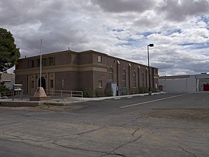
Overton Gymnasium is a historic gymnasium in Overton, Nevada. It was listed on the National Register of Historic Places in 1992. The gymnasium was designed in the Italian Renaissance Revival style by Miles E. Miller in 1938-39 under the Public Works Administration program.

LDS Moapa Stake Office Building
Historic building in Nevada, US
Distance: Approx. 4333 meters
Latitude and longitude: 36.54027778,-114.44435833
LDS Moapa Stake Office Building, also known as the Virmoa Maternity Hospital, is listed on the National Register of Historic Places in Overton, Nevada. It was built between 1917 and 1919 to serve the community of Moapa Valley as a local office, classroom and records repository for the LDS Church. In 1939, the local stake decided to relocate their offices to Las Vegas as travel between the communities became easier.
Moapa Valley High School
Public high school in Overton, Nevada, United States
Distance: Approx. 2237 meters
Latitude and longitude: 36.58513333,-114.4583139
Moapa Valley High School is a 3A public high school in Overton, Nevada, United States and is part of the Clark County School District (CCSD). It has an approximated number of students of 562. The school mascot is the pirate.
Saint Joseph, Nevada
Ghost town in Nevada, United States
Distance: Approx. 2294 meters
Latitude and longitude: 36.57277778,-114.44972222
Saint Joseph is a ghost town in Clark County, Nevada, that was located on the east bank of the Muddy River west of the north end of the Perkins Field in the Moapa Valley.
Simonsville, Nevada
Ghost town in Nevada, United States
Distance: Approx. 2874 meters
Latitude and longitude: 36.56277778,-114.44444444
Simonsville is a ghost town in Clark County, Nevada, that was located on the east bank of the Muddy River west of the south end of the Overton Airport in the Moapa Valley.
Weather in this IP's area
clear sky
27 Celsius
27 Celsius
27 Celsius
27 Celsius
1010 hPa
39 %
1010 hPa
965 hPa
10000 meters
0.39 m/s
1.04 m/s
298 degree
3 %
06:15:16
18:55:50
