199.47.178.235 - IP Lookup: Free IP Address Lookup, Postal Code Lookup, IP Location Lookup, IP ASN, Public IP
Country:
 Australia
Region:
City:
Location:
Time Zone:
Postal Code:
ISP:
ASN:
language:
User-Agent:
Proxy IP:
Blacklist:
IP information under different IP Channel
ip-api
Country
Region
City
ASN
Time Zone
ISP
Blacklist
Proxy
Latitude
Longitude
Postal
Route
db-ip
Country
Region
City
ASN
Time Zone
ISP
Blacklist
Proxy
Latitude
Longitude
Postal
Route
IPinfo
Country
Region
City
ASN
Time Zone
ISP
Blacklist
Proxy
Latitude
Longitude
Postal
Route
IP2Location
199.47.178.235Country
auRegion
new south wales
City
north ryde
Time Zone
Australia/Sydney
ISP
Language
User-Agent
Latitude
Longitude
Postal
ipdata
Country
Region
City
ASN
Time Zone
ISP
Blacklist
Proxy
Latitude
Longitude
Postal
Route
Popular places and events near this IP address

Australian Astronomical Observatory
Observatory
Distance: Approx. 1918 meters
Latitude and longitude: -33.79621012,151.14511752
The Australian Astronomical Observatory (AAO), formerly the Anglo-Australian Observatory, was an optical and near-infrared astronomy observatory with its headquarters in North Ryde in suburban Sydney, Australia. Originally funded jointly by the United Kingdom and Australian governments, it was managed wholly by Australia's Department of Industry, Innovation, Science, Research and Tertiary Education. The AAO operated the 3.9-metre Anglo-Australian Telescope (AAT) and 1.2-metre UK Schmidt Telescope (UKST) at Siding Spring Observatory, located near the town of Coonabarabran, Australia.
North Ryde, New South Wales
Suburb of Sydney, New South Wales, Australia
Distance: Approx. 663 meters
Latitude and longitude: -33.79242,151.11954
North Ryde is a suburb located in the Northern Sydney region of Sydney, New South Wales, Australia. North Ryde is located 15 kilometres north-west of the Sydney central business district, in the local government area of the City of Ryde. One of Australia's major business districts, North Ryde is home to many multi-national corporations such as Hewlett-Packard, Oracle and Honeywell.

North Ryde railway station
Sydney Metro railway station
Distance: Approx. 1320 meters
Latitude and longitude: -33.794676,151.138439
North Ryde railway station is located on the Metro North West & Bankstown Line, serving the Sydney suburb of North Ryde, New South Wales, Australia. Formerly part of Sydney Trains' T1 Northern Line, the station started operating under the Sydney Metro network from May 2019.

Macquarie Park railway station
Sydney Metro railway station
Distance: Approx. 1354 meters
Latitude and longitude: -33.785095,151.128391
Macquarie Park railway station is located on the Sydney Metro network, serving the suburb of Macquarie Park. It was formerly part of Sydney Trains' T1 Northern Line, before being converted to service the Metro North West & Bankstown Line.
East Ryde, New South Wales
Suburb of Sydney, New South Wales, Australia
Distance: Approx. 1767 meters
Latitude and longitude: -33.81,151.135
East Ryde is a suburb of Sydney in the state of New South Wales, Australia. East Ryde is in the Northern Sydney region and is located 12 kilometers north-west of the Sydney central business district, in the local government area of the City of Ryde. East Ryde sits on the western bank of the Lane Cove River.

Ryde Secondary College
Secondary school in New South Wales, Australia
Distance: Approx. 1919 meters
Latitude and longitude: -33.8134,151.1188
Ryde Secondary College is a government-funded co-educational dual modality partially academically selective and comprehensive secondary day school, located in Ryde, a suburb of Sydney, New South Wales, Australia. Established in 1965 as Malvina High School, Ryde Secondary College caters for approximately 1,000 students from Year 7 to Year 12. It is one of the few schools in New South Wales which takes enrolments for selective students, mainstream students as well as those who need special education (support unit students).

Sydney Turpentine-Ironbark Forest
Critically endangered forest in Australia
Distance: Approx. 1054 meters
Latitude and longitude: -33.79443333,151.13543333
The Sydney Turpentine-Ironbark Forest (STIF) is a wet sclerophyll forest community of Sydney, New South Wales, Australia, that is typically found in the Inner West and Northern region of Sydney. It is also among the three of these plant communities which have been classified as Endangered, under the New South Wales government's Threatened Species Conservation Act 1995, with only around 0.5% of its original pre-settlement range remaining. As of 26 August 2005, the Australian Government reclassified Sydney Turpentine-Ironbark Forest as a "Critically Endangered Ecological Community", under the Commonwealth's Environment Protection and Biodiversity Conservation Act 1999.
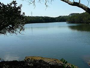
Lane Cove River Tourist Park
Distance: Approx. 1916 meters
Latitude and longitude: -33.78952778,151.14316667
Lane Cove River Tourist Park is a caravan park and campground in the Australian state of New South Wales located in the suburb of Macquarie Park within the boundaries of the Lane Cove National Park and about 10 kilometres (6.2 mi) north of the Sydney Harbour Bridge. It is operated by the NSW National Parks & Wildlife Service. It is located on the western side of national park.
Arndell School
Public, co-educational, special school in North Ryde, New South Wales, Australia
Distance: Approx. 831 meters
Latitude and longitude: -33.80416667,151.12583333
Arndell School is a specialised school funded by the NSW Department of Education for students with emotional and behavioural difficulties. It works in partnership with the Coral Tree Family Services and is located in the Macquarie Hospital grounds in North Ryde. The school provides educational programs with an emphasis on literacy and numeracy for a maximum of 35 students aged from 4.5 to 12 years (K to Year 6).

Wallumatta Nature Reserve
Protected area in New South Wales, Australia
Distance: Approx. 1137 meters
Latitude and longitude: -33.80611111,151.12944444
Wallumatta Nature Reserve, also called the Macquarie Hospital Bushland, is a 6-hectare (15-acre) nature reserve bushland area, surrounded by the residential suburb of East Ryde, in suburban Sydney, Australia. Once part of the Field of Mars of 1804, the reserve is the largest surviving area of Sydney Turpentine-Ironbark Forest, an endangered ecosystem. Soils are based on Ashfield Shale and Hawkesbury Sandstone.
Lachlan's Square Village
Shopping mall in New South Wales, Australia
Distance: Approx. 972 meters
Latitude and longitude: -33.79268,151.13366
Lachlan's Square Village is a shopping centre in the suburb of Macquarie Park in Northern Sydney.

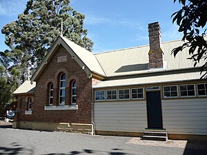
NSW Schoolhouse Museum
Education museum in Sydney, Australia
Distance: Approx. 363 meters
Latitude and longitude: -33.794633,151.121475
The NSW Schoolhouse Museum, also known as the New South Wales Schoolhouse Museum of Public Education, is located within the school grounds of North Ryde Public School in North Ryde, a suburb of Sydney, New South Wales, Australia. The museum includes a replica of an 1870s classroom to be found in the original 1877 school building. It was restored by volunteers in 1992 and officially opened by Virginia Chadwick, then the NSW Minister for Education in November 1992.
Weather in this IP's area
broken clouds
28 Celsius
30 Celsius
26 Celsius
29 Celsius
1011 hPa
67 %
1011 hPa
1002 hPa
10000 meters
1.34 m/s
3.13 m/s
174 degree
64 %