199.47.177.218 - IP Lookup: Free IP Address Lookup, Postal Code Lookup, IP Location Lookup, IP ASN, Public IP
Country:
 USA
USARegion:
City:
Location:
Time Zone:
Postal Code:
ISP:
ASN:
language:
User-Agent:
Proxy IP:
Blacklist:
IP information under different IP Channel
ip-api
Country
Region
City
ASN
Time Zone
ISP
Blacklist
Proxy
Latitude
Longitude
Postal
Route
db-ip
Country
Region
City
ASN
Time Zone
ISP
Blacklist
Proxy
Latitude
Longitude
Postal
Route
IPinfo
Country
Region
City
ASN
Time Zone
ISP
Blacklist
Proxy
Latitude
Longitude
Postal
Route
IP2Location
199.47.177.218Country
usRegion
california
City
citrus heights
Time Zone
America/Los_Angeles
ISP
Language
User-Agent
Latitude
Longitude
Postal
ipdata
Country
Region
City
ASN
Time Zone
ISP
Blacklist
Proxy
Latitude
Longitude
Postal
Route
Popular places and events near this IP address

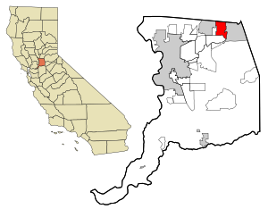
Citrus Heights, California
City in California, United States
Distance: Approx. 1655 meters
Latitude and longitude: 38.7,-121.28333333
Citrus Heights is a city in Sacramento County, California, United States. As of the 2020 U.S. Census, the city had a population of 87,583, up from 83,301 at the 2010 U.S. Census.
Orangevale, California
Census-designated place in California, United States
Distance: Approx. 4705 meters
Latitude and longitude: 38.68194444,-121.21388889
Orangevale is a census-designated place (CDP) in Sacramento County, California, United States. It is part of the Sacramento–Arden-Arcade–Roseville Metropolitan Statistical Area. The population was 33,960 at the 2010 census, up from 26,705 at the 2000 census.

Rusch Botanical Gardens
Botanical garden in Citrus Heights, California, US
Distance: Approx. 3307 meters
Latitude and longitude: 38.70833333,-121.29944444
The Rusch Botanical Gardens 2 acres (8,000 m2) are located at 7801 Auburn Boulevard in Citrus Heights, California, United States within Rusch Park. The Rusch Home site dates back to 1858. Originally Gardens were laid out in 1916.

Bella Vista High School
Public school in Fair Oaks, California , United States
Distance: Approx. 3535 meters
Latitude and longitude: 38.66522,-121.25189
Bella Vista High School is a public high school in Fair Oaks, California. It is a member of the San Juan Unified School District and serves eastern Fair Oaks and southern Orangevale. In 2003, the California Department of Education's School Recognition Program honored Bella Vista High School as a "California Distinguished School".

Sunrise Mall (Citrus Heights, California)
Shopping mall in Citrus Heights, California
Distance: Approx. 2275 meters
Latitude and longitude: 38.67497,-121.26901
Sunrise Mall is a single-level regional shopping mall located at the intersection of Sunrise Boulevard and Greenback Lane in Citrus Heights, California, United States, in the Sacramento metropolitan area. It is one of the area’s largest and most successful enclosed super regional shopping centers. The mall is the centerpiece of the Sunrise MarketPlace shopping district in Citrus Heights.

Casa Roble High School
Public school in Orangevale, California, United States
Distance: Approx. 4460 meters
Latitude and longitude: 38.701,-121.2145
Casa Roble Fundamental High School is a public high school located in Orangevale, California. It is a part of the San Juan Unified School District with a student body of approximately 1250 students from northern Orangevale and a portion of Citrus Heights.

Oakmont High School
Public school in Roseville, California , United States
Distance: Approx. 3669 meters
Latitude and longitude: 38.728,-121.2611
Oakmont High School is located at 1710 Cirby Way, in Roseville, California, United States. The school is surrounded by the communities of Citrus Heights, Rocklin, Granite Bay, and Antelope. It is one of five comprehensive high schools in the Roseville Joint Union High School District.
Mesa Verde High School
School in Citrus Heights, California, United States
Distance: Approx. 2886 meters
Latitude and longitude: 38.70204,-121.29734
Mesa Verde High School is a public high school in Citrus Heights, California in the San Juan Unified School District.
San Juan High School (California)
School in Citrus Heights, California, United States
Distance: Approx. 2647 meters
Latitude and longitude: 38.67898,-121.28758
San Juan High School is an American public high school in Citrus Heights, California in the San Juan Unified School District.
Rancho San Juan
Mexican land grant in California
Distance: Approx. 4493 meters
Latitude and longitude: 38.66,-121.24
Rancho San Juan was a 19,983-acre (80.87 km2) Mexican land grant in present-day Sacramento County, California given in 1844 by Governor Manuel Micheltorena to Joel P. Dedmond. The grant extended east of Captain Eliab Grimes Rancho Del Paso along the north bank of the American River, across from William Leidesdorff's Rancho Rio de los Americanos, and encompassed present-day Orangevale, Fair Oaks and most of Carmichael.

Maidu Regional Park
Distance: Approx. 4686 meters
Latitude and longitude: 38.7351,-121.2481
The Maidu Regional Park is located in Roseville, California. This 152-acre park has a small museum and historic site. The grounds also consist of the Maidu Community Center, the Maidu Branch Library, and Veterans Memorial Rose Garden.
Stones Gambling Hall cheating scandal
Unorthodox poker playing that minimized losses
Distance: Approx. 1999 meters
Latitude and longitude: 38.6923,-121.288
In late September 2019, Stones Gambling Hall, located in Citrus Heights, near Sacramento, California, came to prominence due to a cheating scandal that became known as Postlegate. Mike Postle was publicly accused of cheating in poker games he participated in during livestream events hosted at Stones Gambling Hall. "Stones Live" livestream poker games utilized playing cards with embedded RFID sensors that scanned the playing cards and transmitted identifying information (the cards' suits and ranks) into the livestream's technical control room and to play-by-play announcers and color commentators; casino management and livestream supervisors also had access to real-time identifying information of otherwise unknown, facedown, cards.
Weather in this IP's area
clear sky
12 Celsius
11 Celsius
11 Celsius
13 Celsius
1025 hPa
51 %
1025 hPa
1018 hPa
10000 meters
5.14 m/s
320 degree