199.46.97.107 - IP Lookup: Free IP Address Lookup, Postal Code Lookup, IP Location Lookup, IP ASN, Public IP
Country:
Region:
City:
Location:
Time Zone:
Postal Code:
ISP:
ASN:
language:
User-Agent:
Proxy IP:
Blacklist:
IP information under different IP Channel
ip-api
Country
Region
City
ASN
Time Zone
ISP
Blacklist
Proxy
Latitude
Longitude
Postal
Route
db-ip
Country
Region
City
ASN
Time Zone
ISP
Blacklist
Proxy
Latitude
Longitude
Postal
Route
IPinfo
Country
Region
City
ASN
Time Zone
ISP
Blacklist
Proxy
Latitude
Longitude
Postal
Route
IP2Location
199.46.97.107Country
Region
tennessee
City
clarksville
Time Zone
America/Chicago
ISP
Language
User-Agent
Latitude
Longitude
Postal
ipdata
Country
Region
City
ASN
Time Zone
ISP
Blacklist
Proxy
Latitude
Longitude
Postal
Route
Popular places and events near this IP address

Austin Peay State University
Public university in Clarksville, Tennessee, U.S.
Distance: Approx. 434 meters
Latitude and longitude: 36.5323,-87.35457
Austin Peay State University (APSU) () is a public university in Clarksville, Tennessee. Standing on a site occupied by a succession of educational institutions since 1845, the precursor of the university was established in 1927 and named for then-sitting Governor Austin Peay, who is further honored with "Governors", the name of the university's athletic teams. Affiliated with the Tennessee Board of Regents, it is now governed by the Austin Peay State University Board of Trustees as of May 2017.

Fortera Stadium
Stadium on the campus of Austin Peay State University in Clarksville, Tennessee
Distance: Approx. 621 meters
Latitude and longitude: 36.53611111,-87.35277778
Fortera Stadium is a stadium located on the campus of Austin Peay State University in Clarksville, Tennessee. It opened in 1946 and is the home venue for the Austin Peay Governors football team.
Clarksville station
Railway station in the USA
Distance: Approx. 482 meters
Latitude and longitude: 36.5285,-87.345597
The Louisville and Nashville Railroad Train Station is a restored railroad station in Clarksville, Tennessee. It was opened by the Memphis, Clarksville and Louisville Railroad in 1859. The station area, located at 10th St and Commerce, was restored in 1996 to circa 1901 AD condition and includes a diesel locomotive donated by RJ Corman and a caboose donated by the Pratt Museum at Fort Campbell.
Catholic Church and Rectory
Historic church in Tennessee, United States
Distance: Approx. 247 meters
Latitude and longitude: 36.52888889,-87.35083333
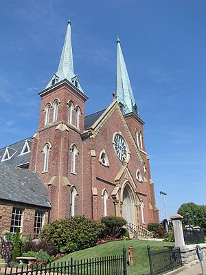
Catholic Church and Rectory, formally The Immaculate Conception Church, is a historic Roman Catholic church at 716 Franklin Street in Clarksville, Tennessee. The Gothic style building was constructed in 1880, and added to the National Register of Historic Places in 1982.

Clarksville Methodist Church
Historic church in Tennessee, United States
Distance: Approx. 641 meters
Latitude and longitude: 36.52888889,-87.35666667
Clarksville Methodist Church is a historic church building at 334 Main Street in Clarksville, Tennessee. Currently, the building isn't used as a church. The church was built in 1831, the first permanent church building in Clarksville and one of the city's first brick buildings.
First Presbyterian Church (Clarksville, Tennessee)
Historic church in Tennessee, United States
Distance: Approx. 797 meters
Latitude and longitude: 36.52916667,-87.35861111
First Presbyterian Church is a historic church at 213 Main Street in Clarksville, Tennessee. The congregation is currently affiliated with the Presbyterian Church (USA).
First Presbyterian Church Manse (Clarksville, Tennessee)
Historic church in Tennessee, United States
Distance: Approx. 725 meters
Latitude and longitude: 36.52916667,-87.35777778
First Presbyterian Church Manse (Farris Apartments) is a historic church manse at 305 Main Street in Clarksville, Tennessee. It was built in 1890 and added to the National Register in 2001.
St. Peter African Methodist Church
Historic church in Tennessee, United States
Distance: Approx. 457 meters
Latitude and longitude: 36.52833333,-87.35388889
St. Peter African Methodist Church is a historic church at 518 Franklin Street in Clarksville, Tennessee, United States. The Gothic Revival church building was constructed in 1873 and added to the National Register of Historic Places in 1982.
Trinity Episcopal Church (Clarksville, Tennessee)
Historic church in Tennessee, United States
Distance: Approx. 761 meters
Latitude and longitude: 36.52777778,-87.3575
Trinity Episcopal Church is a historic church at 317 Franklin Street in Clarksville, Tennessee. The church and its rectory are listed on the National Register of Historic Places as Trinity Church and Rectory. The Trinity Episcopal parish is one of the five oldest Episcopal parishes in Tennessee, established in 1832.
Samuel Rexinger House
United States historic place
Distance: Approx. 270 meters
Latitude and longitude: 36.53194444,-87.35277778
The Samuel Rexinger House, also known as Archwood, is a historic mansion in Clarksville, Tennessee, U.S.. It is the residence of the president of Austin Peay State University. The house was built in 1878 for Samuel Rexinger, the postmaster of Clarksville from 1867 to 1883.
Northington-Beach House
United States historic place
Distance: Approx. 685 meters
Latitude and longitude: 36.52583333,-87.35416667
The Northington-Beach House is a historic mansion in Clarksville, Tennessee, U.S.. It was built in 1886 for Michael C. Northington, a tobacco merchant who served as the mayor of Clarskville from 1906 to 1910. In 1925, it was purchased by Oscar Beach, the founder of the Pan-American Oil Company.
Johnson-Hach House
United States historic place
Distance: Approx. 779 meters
Latitude and longitude: 36.52444444,-87.34694444
The Johnson-Hach House is a historic house in Clarksville, Tennessee, U.S.. It was built circa 1877 for Polk Grundy Johnson, the son of Congressman Cave Johnson. It was purchased in 1917 by Adolph Hach, a German-born businessman who invested in tobacco production.
Weather in this IP's area
overcast clouds
-4 Celsius
-11 Celsius
-4 Celsius
-4 Celsius
1023 hPa
81 %
1023 hPa
1002 hPa
6565 meters
7.17 m/s
10 m/s
326 degree
100 %


