Country:
 USA
USARegion:
City:
Latitude and Longitude:
Time Zone:
Postal Code:
IP information under different IP Channel
ip-api
Country
Region
City
ASN
Time Zone
ISP
Blacklist
Proxy
Latitude
Longitude
Postal
Route
IPinfo
Country
Region
City
ASN
Time Zone
ISP
Blacklist
Proxy
Latitude
Longitude
Postal
Route
MaxMind
Country
Region
City
ASN
Time Zone
ISP
Blacklist
Proxy
Latitude
Longitude
Postal
Route
Luminati
Country
USASN
Time Zone
America/Chicago
ISP
ARIN-ASH-CHA
Latitude
Longitude
Postal
db-ip
Country
Region
City
ASN
Time Zone
ISP
Blacklist
Proxy
Latitude
Longitude
Postal
Route
ipdata
Country
Region
City
ASN
Time Zone
ISP
Blacklist
Proxy
Latitude
Longitude
Postal
Route
Popular places and events near this IP address
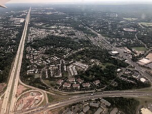
Centreville, Virginia
Census-designated place in Virginia, United States
Distance: Approx. 840 meters
Latitude and longitude: 38.8425,-77.4425
Centreville is a census-designated place (CDP) in Fairfax County, Virginia, United States. It is a suburb of Washington, D.C., the nation's capital.
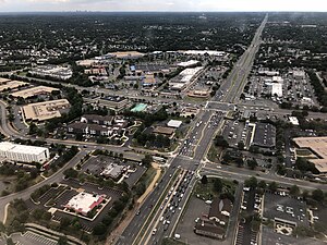
Chantilly, Virginia
CDP in Virginia, United States
Distance: Approx. 4761 meters
Latitude and longitude: 38.875,-77.4025
Chantilly is a census-designated place (CDP) in western Fairfax County, Virginia. The population was 24,301 as of the 2020 census. Chantilly is named after an early-19th-century mansion and farm, which in turn took the name of an 18th-century plantation that was located in Westmoreland County, Virginia.

Battle of Blackburn's Ford
Battle of the American Civil War
Distance: Approx. 4182 meters
Latitude and longitude: 38.80416667,-77.44916667
The Battle of Blackburn's Ford (also known as the Skirmish at Blackburn's Ford) took place on July 18, 1861, in the Confederate state of Virginia, as part of the Manassas campaign of the American Civil War. Union general Irvin McDowell's Army of Northeastern Virginia was marching south towards the Confederate capital of Richmond, and encountered the Confederate Army of the Potomac under the command of P. G. T. Beauregard. McDowell sent troops from Daniel Tyler's division to probe the Confederate defenses along Bull Run Creek to locate the Confederate left flank.

Blackburn's Ford
Distance: Approx. 4307 meters
Latitude and longitude: 38.80304,-77.44939
Blackburn's Ford was the crossing of Bull Run by Centreville Road between Manassas and Centreville, Virginia, in the United States. It was named after the original owner of the Yorkshire Plantation (McLean's Farm), Col. Richard Blackburn, formerly of Yorkshire, England.
Centreville High School (Fairfax County, Virginia)
High school in Clifton, Virginia, United States
Distance: Approx. 2558 meters
Latitude and longitude: 38.825,-77.41083333
Centreville High School (CVHS) is a public high school located in unincorporated southwestern Fairfax County, Virginia, north of Clifton and east of the Centreville. Having opened in 1988 to serve the rapidly growing population of the Clifton/Centreville region, CVHS is the top of the Centreville High School Pyramid in Region 4 of the Fairfax County Public School (FCPS) system. In 2010 the school was ranked as the 4th best high school in Fairfax County, and the 18th best high school out of 172 schools rated in the Washington, D.C. metropolitan area.

Centreville Military Railroad
Distance: Approx. 571 meters
Latitude and longitude: 38.83461111,-77.43269444
The Centreville Military Railroad was a 5.5-mile (8.9 km) spur running from the Orange and Alexandria Railroad east of Manassas Junction across Bull Run and up the south side of the Centreville Plateau. Built by the Confederate States Army between November 1861 and February 1862, it was the first exclusively military railroad. Ultimately, the Centreville Military Railroad reached a point near a modern McDonald's restaurant on Virginia State Route 28, south of the modern junction with U.S. Route 29 in Virginia.

Korean Central Presbyterian Church
Church in U.S., United States
Distance: Approx. 4219 meters
Latitude and longitude: 38.829337,-77.480295
Korean Central Presbyterian Church (KCPC; Korean: 와싱톤중앙장로교회) is an Evangelical Christian megachurch located in Centreville, Virginia, situated in the Washington D.C. in the US. Korean Central Presbyterian Church is a member congregation of the Presbyterian Church in America.
Uniontown, Virginia
Unincorporated community in Virginia, United States
Distance: Approx. 2625 meters
Latitude and longitude: 38.82083333,-77.45166667
Uniontown is an unincorporated community in Fairfax County, in the U.S. state of Virginia.
Mountain View Alternative High School
Public school in the United States
Distance: Approx. 731 meters
Latitude and longitude: 38.8375,-77.42555556
Mountain View Alternative High School is a public alternative high school in the unincorporated community of Centreville, Virginia, United States. It is part of Fairfax County Public Schools. Mountain View is one of two alternative high schools operated by Fairfax County Public Schools and offers programs for students who require a nontraditional educational setting.

Greenbriar, Virginia
Census-designated place in Virginia, United States
Distance: Approx. 4639 meters
Latitude and longitude: 38.87166667,-77.39916667
Greenbriar is a census-designated place in Fairfax County, Virginia, United States. The population at the 2020 census was 8,421. The community between Fairfax City and Chantilly dates from the late 1960s, when it was developed by Levitt & Sons.
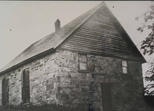
Church of the Ascension, Anglican
Distance: Approx. 340 meters
Latitude and longitude: 38.841039,-77.42998
The Church of the Ascension is an Anglican Catholic church in Centreville, Virginia. The church building is also known locally as "The Old Stone Church", and was built around 1854.
Ellanor C. Lawrence Park
Park in Chantilly, Virginia, United States
Distance: Approx. 2428 meters
Latitude and longitude: 38.86138889,-77.43055556
Ellanor C. Lawrence Park is located in Chantilly, Virginia, just north of Centreville, on Route 28. The park preserves the cultural and natural resources of western Fairfax County and has a long and complex history lasting 8,000 years. The land was originally inhabited by Native Americans, but as Europeans settled in Virginia, the land was shaped by only three families: the Browns, Machens and Lawrences.
Weather in this IP's area
overcast clouds
22 Celsius
22 Celsius
20 Celsius
23 Celsius
1022 hPa
70 %
1022 hPa
1009 hPa
10000 meters
4.12 m/s
70 degree
100 %
06:52:32
19:16:30