199.36.7.203 - IP Lookup: Free IP Address Lookup, Postal Code Lookup, IP Location Lookup, IP ASN, Public IP
Country:
 USA
USARegion:
City:
Location:
Time Zone:
Postal Code:
ISP:
ASN:
language:
User-Agent:
Proxy IP:
Blacklist:
IP information under different IP Channel
ip-api
Country
Region
City
ASN
Time Zone
ISP
Blacklist
Proxy
Latitude
Longitude
Postal
Route
db-ip
Country
Region
City
ASN
Time Zone
ISP
Blacklist
Proxy
Latitude
Longitude
Postal
Route
IPinfo
Country
Region
City
ASN
Time Zone
ISP
Blacklist
Proxy
Latitude
Longitude
Postal
Route
IP2Location
199.36.7.203Country
usRegion
connecticut
City
brookfield
Time Zone
America/New_York
ISP
Language
User-Agent
Latitude
Longitude
Postal
ipdata
Country
Region
City
ASN
Time Zone
ISP
Blacklist
Proxy
Latitude
Longitude
Postal
Route
Popular places and events near this IP address
Brookfield, Connecticut
Town in Connecticut, United States
Distance: Approx. 233 meters
Latitude and longitude: 41.46861111,-73.39194444
Brookfield is a town in Fairfield County, Connecticut, United States, situated within the southern foothills of the Berkshire Mountains. The population was 17,528 at the 2020 census. The town is located 55 miles (89 km) northeast of New York City, making it part of the New York-Newark, NY-NJ-CT-PA combined statistical area.
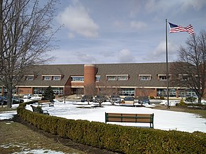
Brookfield High School (Connecticut)
Public high school in Brookfield, Connecticut, United States
Distance: Approx. 1424 meters
Latitude and longitude: 41.480949,-73.390624
Brookfield High School is a public high school serving the town of Brookfield, Fairfield County, Connecticut, United States. The school offers a wide variety of co-curricular and extra-curricular activities, and is frequently ranked by U.S. News & World Report as one of the top high schools in Connecticut and the United States. Brookfield is one of the twenty-one school districts in District Reference Group B. In the 2021–2022 school year the school had 902 students.

Brookfield Center Historic District (Brookfield, Connecticut)
Historic district in Connecticut, United States
Distance: Approx. 106 meters
Latitude and longitude: 41.46777778,-73.38805556
The Brookfield Center Historic District in Brookfield, Connecticut is a historic district that was listed on the National Register of Historic Places in 1991. It is located in the vicinity of the junction of Route 133 and Route 25. The district represents the original settlement of the town of Brookfield and contains 67 residential, religious, and municipal buildings over a 43-acre (17 ha) area representing a wide range of architectural styles from the 18th to 20th centuries including Bungalow/Craftsman, Greek Revival, and Queen Anne style architecture.

Brookfield Center, Connecticut
Census-designated place in Connecticut, United States
Distance: Approx. 327 meters
Latitude and longitude: 41.46555556,-73.3875
Brookfield Center is a census-designated place (CDP) in the town of Brookfield, Fairfield County, Connecticut, United States. It includes the 43-acre (17 ha) Brookfield Center Historic District around the intersection of Connecticut Routes 25 and 133, as well as surrounding residential neighborhoods. Brookfield Center was first listed as a CDP prior to the 2020 census.

Brookfield Craft Center
Distance: Approx. 2211 meters
Latitude and longitude: 41.4822,-73.408
Brookfield Craft Center, located in Brookfield, Connecticut, is a 501(c)(3) not-for-profit organization, founded in 1954 with the mission "to teach and preserve the skills of fine craftsmanship and enable creativity and personal growth through craft education." Subjects taught at the craft center include basketry, beadwork, blacksmithing, bladesmithing, ceramics, glass, jewelry making, metalsmithing, fiber and weaving, woodturning, woodworking, photography, paper and book arts, decorative arts, painting and drawing, and business / marketing for artists. Its 2.5-acre (1.0 ha) campus is located 6 miles (9.7 km) north of Danbury, Connecticut, on the banks of the Still River, with an historic mill building as its centerpiece. Its six buildings house seven fully equipped studios, an exhibition gallery, a retail craft gallery and gift shop, and housing for visiting faculty.

St. Joseph Church (Brookfield, Connecticut)
Church in Connecticut, United States
Distance: Approx. 334 meters
Latitude and longitude: 41.46530556,-73.38815556
St. Joseph is a Roman Catholic church in Brookfield, Connecticut, part of the Diocese of Bridgeport.

St. Marguerite Bourgeoys Church
Church in Connecticut, United States
Distance: Approx. 2955 meters
Latitude and longitude: 41.45411389,-73.41922778
St. Marguerite Bourgeoys Parish is a Roman Catholic church in Brookfield, Connecticut, part of the Diocese of Bridgeport.

Still River Greenway
Trail in Brookfield, Connecticut
Distance: Approx. 1015 meters
Latitude and longitude: 41.46780556,-73.40136111
The Still River Greenway is a multi-use trail and greenway along the Still River in Brookfield, Connecticut. With both phases complete, the trail runs from the Brookfield Municipal Center to the Brookfield Town Center (also known as the "Four Corners" district) and is completely paved. The other section of the trail runs from the Municipal Center, and loops around in the woods.
Brookfield Theatre for the Arts
Distance: Approx. 190 meters
Latitude and longitude: 41.4693469,-73.3908915
The Brookfield Theatre for the Arts is a theater located in the historic Curtis School for Boys gymnasium building in Brookfield, Connecticut, located within the Brookfield Center Historic District. The theater has a capacity of 135 people and hosts a variety of entertainment events such as films, plays, and musical performances. Every year five community productions are chosen including comedies, dramas, musicals, and classics.

Candlewood Orchards, Connecticut
Census-designated place in Connecticut, United States
Distance: Approx. 4304 meters
Latitude and longitude: 41.475,-73.44
Candlewood Orchards is a private residential community and census-designated place (CDP) in the town of Brookfield, Fairfield County, Connecticut, United States. It is in the northwestern part of the town, on the eastern shore of Candlewood Lake. It is bordered to the north by Candlewood Shores and to the west and south by the town of New Fairfield.

Sunset Hill Golf Club
American public golf course
Distance: Approx. 1866 meters
Latitude and longitude: 41.451649,-73.385635
Sunset Hill Golf Club is a public golf course located at 13 Sunset Hill Road in Brookfield, Connecticut. The course was designed in 1936 by Gene Sarazen as a practice course for himself, to use while staying at his residence in Brookfield. Sarazen began opening the course to the public in the late 1930s.

Brookfield Junction station
Former rail station in Brookfield, Connecticut.
Distance: Approx. 1755 meters
Latitude and longitude: 41.45265,-73.3927
Brookfield Junction was a station on the main line of the Housatonic Railroad and later the Pittsfield Branch of the New York, New Haven, and Hartford Railroad. Opened in 1869, the station was originally located on Stony Hill Road in the southern part of Brookfield, Connecticut. The station was closed in 1925 and was later demolished in the 1930s.
Weather in this IP's area
heavy snow
-3 Celsius
-7 Celsius
-4 Celsius
-2 Celsius
1019 hPa
87 %
1019 hPa
995 hPa
402 meters
2.57 m/s
150 degree
100 %