Country:
Region:
City:
Latitude and Longitude:
Time Zone:
Postal Code:
IP information under different IP Channel
ip-api
Country
Region
City
ASN
Time Zone
ISP
Blacklist
Proxy
Latitude
Longitude
Postal
Route
IPinfo
Country
Region
City
ASN
Time Zone
ISP
Blacklist
Proxy
Latitude
Longitude
Postal
Route
MaxMind
Country
Region
City
ASN
Time Zone
ISP
Blacklist
Proxy
Latitude
Longitude
Postal
Route
Luminati
Country
Region
or
City
portland
ASN
Time Zone
America/Los_Angeles
ISP
STERLING
Latitude
Longitude
Postal
db-ip
Country
Region
City
ASN
Time Zone
ISP
Blacklist
Proxy
Latitude
Longitude
Postal
Route
ipdata
Country
Region
City
ASN
Time Zone
ISP
Blacklist
Proxy
Latitude
Longitude
Postal
Route
Popular places and events near this IP address

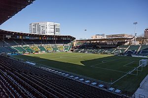
Providence Park
Sports stadium in Portland, Oregon, United States
Distance: Approx. 273 meters
Latitude and longitude: 45.52138889,-122.69166667
Providence Park (formerly Jeld-Wen Field; PGE Park; Civic Stadium; originally Multnomah Stadium; and from 1893 until the stadium was built, Multnomah Field) is an outdoor soccer venue located in the Goose Hollow neighborhood of Portland, Oregon. It has existed in rudimentary form since 1893, and as a complete stadium since 1926. Providence Park is currently the oldest facility to be configured as a soccer-specific stadium for use by a MLS team, and is one of the most historic grounds used by any United States professional soccer team.

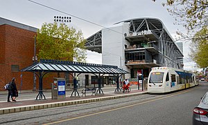
Goose Hollow/Southwest Jefferson Street station
Distance: Approx. 237 meters
Latitude and longitude: 45.518264,-122.692825
Goose Hollow/Southwest Jefferson Street is a light rail station on the MAX Blue and Red Lines in the Goose Hollow neighborhood of Portland, Oregon. It is the third stop westbound on the Westside MAX alignment and makes several cameo appearances in the movie What the Bleep Do We Know!? as the stop where Marlee Matlin's character boards the train to get into town.

Kings Hill/Southwest Salmon Street station
MAX Light Rail station in Portland, Oregon, U.S.
Distance: Approx. 144 meters
Latitude and longitude: 45.52027778,-122.69111111
Kings Hill/Southwest Salmon Street is a former light rail station in Portland, Oregon, United States, which was served by the Blue and Red lines of TriMet's MAX Light Rail. The station was situated within the Goose Hollow neighborhood. Its incorrectly punctuated name refers to the hillside to the west of the station, which has historically been referred to as King's Hill.

Lincoln High School (Portland, Oregon)
Public high school in Portland, Oregon
Distance: Approx. 145 meters
Latitude and longitude: 45.51889,-122.6883
Lincoln High School (LHS) is a public high school located in the Goose Hollow neighborhood of Portland, Oregon, United States. It was established in 1869 as Portland High School. Its attendance boundary includes Downtown Portland, Goose Hollow, Northwest Portland, and a part of West Haven-Sylvan.
Goose Hollow, Portland, Oregon
Neighborhood in Portland, Oregon, United States
Distance: Approx. 230 meters
Latitude and longitude: 45.51963,-122.69299
Goose Hollow is a neighborhood in southwest Portland, Oregon. It acquired its distinctive name through early residents' practice of letting their geese run free in Tanner Creek Gulch and near the wooded ravine in the Tualatin Mountains known as the Tanner Creek Canyon. Tanner Creek Gulch was a 20-block-long, 50-foot-deep (15 m) gulch (or hollow) that started around SW 17th and Jefferson and carried the waters of Tanner Creek into Couch Lake (now the site of Old Town/Chinatown and the Pearl District).

Multnomah Athletic Club
Private club in Portland, Oregon, U.S.
Distance: Approx. 256 meters
Latitude and longitude: 45.5206,-122.6927
The Multnomah Athletic Club (MAC) is a private social and athletic club in Portland, Oregon, United States. It was founded in 1891 as the Multnomah Amateur Athletic Club, a coordinating body for team and individual sports such as track and field, football, and basketball and fielded its own competitive teams against collegiate competition. It is currently a 21,000 member institution, providing athletic and dining facilities to its dues-payers.
Oregon Parks Forever
U.S. non-profit organization
Distance: Approx. 192 meters
Latitude and longitude: 45.517587,-122.68924
Oregon Parks Forever (formerly the Oregon State Parks Foundation) is a U.S. non-profit organization dedicated to the preservation and enhancement of state parks in Oregon. The organization is an independent organization with staff and a board.

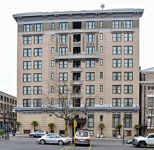
Hotel deLuxe
Hotel and historic building in Portland, Oregon, U.S.
Distance: Approx. 269 meters
Latitude and longitude: 45.520957,-122.687723
The Hotel deLuxe is a hotel located in southwest Portland, Oregon, in the Goose Hollow neighborhood.

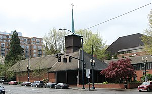
Zion Lutheran Church (Portland, Oregon)
Historic church in Portland, Oregon, U.S.
Distance: Approx. 165 meters
Latitude and longitude: 45.519765,-122.692057
The Zion Lutheran Church is a church located in downtown Portland, Oregon, listed on the National Register of Historic Places. Architect Pietro Belluschi employed a number of innovations in this 1950 church, an example of the application of modern architectural principles to a religious building. Using local materials, influences, and artists and craftsmen, it represents the Northwest Regional style of modern architecture, which Belluschi (along with colleague John Yeon) originated and developed.
Oregon Culinary Institute
Private For-profit Culinary school in Portland, Oregon
Distance: Approx. 171 meters
Latitude and longitude: 45.51805556,-122.69155556
Oregon Culinary Institute (OCI) was a privately owned, for-profit, accredited trade school located in Portland, Oregon, United States that was part of the Pioneer Pacific College system. It offered programs in culinary arts, baking and pastry, and restaurant management, with a curriculum to prepare graduates for the food-service industry. OCI's campus was located in the Goose Hollow neighborhood of southwest Portland, and included a restaurant staffed by students.
Press Blocks
Mixed-use development in Portland, Oregon, U.S.
Distance: Approx. 185 meters
Latitude and longitude: 45.520839,-122.689703
The Press Blocks is a three-building, mixed-use development planned for Portland, Oregon's Goose Hollow neighborhood, in the United States. The $20 million purchase by Urban Renaissance Group and Security Properties closed in February 2017. Prior to construction of the new buildings, multiple buildings will be demolished, including one that formerly housed The Oregonian's printing press.

Cheerful Bullpen
Pub in Portland, Oregon, U.S.
Distance: Approx. 159 meters
Latitude and longitude: 45.5206,-122.6905
Cheerful Bullpen is a pub in Portland, Oregon, United States.
Weather in this IP's area
few clouds
24 Celsius
24 Celsius
23 Celsius
26 Celsius
1010 hPa
50 %
1010 hPa
1006 hPa
10000 meters
5.14 m/s
7.2 m/s
300 degree
20 %
06:51:11
19:19:48