199.27.97.253 - IP Lookup: Free IP Address Lookup, Postal Code Lookup, IP Location Lookup, IP ASN, Public IP
Country:
Region:
City:
Location:
Time Zone:
Postal Code:
ISP:
ASN:
language:
User-Agent:
Proxy IP:
Blacklist:
IP information under different IP Channel
ip-api
Country
Region
City
ASN
Time Zone
ISP
Blacklist
Proxy
Latitude
Longitude
Postal
Route
db-ip
Country
Region
City
ASN
Time Zone
ISP
Blacklist
Proxy
Latitude
Longitude
Postal
Route
IPinfo
Country
Region
City
ASN
Time Zone
ISP
Blacklist
Proxy
Latitude
Longitude
Postal
Route
IP2Location
199.27.97.253Country
Region
comerio
City
comerio
Time Zone
America/Puerto_Rico
ISP
Language
User-Agent
Latitude
Longitude
Postal
ipdata
Country
Region
City
ASN
Time Zone
ISP
Blacklist
Proxy
Latitude
Longitude
Postal
Route
Popular places and events near this IP address

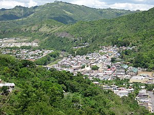
Comerío, Puerto Rico
Town and municipality in Puerto Rico
Distance: Approx. 13 meters
Latitude and longitude: 18.21805556,-66.22611111
Comerío (Spanish pronunciation: [komeˈɾi.o]) is a town and municipality of Puerto Rico in the center-eastern region of island, north of Aibonito; south of Naranjito and Bayamón; east of Barranquitas; and west of Cidra and Aguas Buenas. Comerío is spread over 7 barrios and Comerío Pueblo (the downtown area and the administrative center of the city). It is part of the San Juan-Caguas-Guaynabo Metropolitan Statistical Area.

Arroyata River
River of Puerto Rico
Distance: Approx. 2998 meters
Latitude and longitude: 18.2394,-66.2087789
The Arroyata River (Spanish: Río Arroyata) is a river of Cidra and Comerío, Puerto Rico.

Hondo River (Comerío, Puerto Rico)
River of Puerto Rico
Distance: Approx. 2157 meters
Latitude and longitude: 18.203568,-66.2396124
The Hondo River is a river of Comerío municipality, Puerto Rico.

Río Hondo Bridge
Historic bridge in Comerío, Puerto Rico
Distance: Approx. 2078 meters
Latitude and longitude: 18.208715,-66.243044
The Hondo River Bridge (Spanish: Puente del Río Hondo) was a historic bridge over the Hondo River in Comerío municipality, Puerto Rico. As of 1995, it was the oldest bridge truss in Puerto Rico, employing a double Warren pony truss design and unique open web transverse joists. It was originally installed in 1881 as one of three spans of the Reyes Católicos Bridge over the Plata River on the San Juan–Mayagüez road, using metal parts fabricated in Belgium.

Naranjo, Comerío, Puerto Rico
Barrio of Puerto Rico
Distance: Approx. 3639 meters
Latitude and longitude: 18.228264,-66.193329
Naranjo is a barrio in the municipality of Comerío, Puerto Rico. Its population in 2010 was 1,915.

Piñas, Comerío, Puerto Rico
Barrio of Puerto Rico
Distance: Approx. 2552 meters
Latitude and longitude: 18.195078,-66.226267
Piñas is a barrio in the municipality of Comerío, Puerto Rico. Its population in 2010 was 1,718.

Río Hondo, Comerío, Puerto Rico
Barrio of Puerto Rico
Distance: Approx. 3540 meters
Latitude and longitude: 18.209492,-66.258256
Río Hondo is a barrio in the municipality of Comerío, Puerto Rico. Its population in 2010 was 2300. Río Hondo, a river, is located in this barrio.

Palomas, Comerío, Puerto Rico
Barrio of Puerto Rico
Distance: Approx. 2336 meters
Latitude and longitude: 18.233446,-66.240961
Palomas is a barrio in the municipality of Comerío, Puerto Rico. Its population in 2010 was 4,719.

Cejas, Comerío, Puerto Rico
Barrio of Puerto Rico
Distance: Approx. 3998 meters
Latitude and longitude: 18.208802,-66.189454
Cejas is a barrio in the municipality of Comerío, Puerto Rico. Its population in 2010 was 829.

Doña Elena, Comerío, Puerto Rico
Barrio of Puerto Rico
Distance: Approx. 3894 meters
Latitude and longitude: 18.251773,-66.216406
Doña Elena is a barrio in the municipality of Comerío, Puerto Rico. Its population in 2010 was 3,252.
Vega Redonda, Comerío, Puerto Rico
Barrio of Puerto Rico
Distance: Approx. 2170 meters
Latitude and longitude: 18.20639,-66.209516
Vega Redonda is a barrio in the municipality of Comerío, Puerto Rico. Its population in 2010 was 1,197.

Comerío barrio-pueblo
Historical and administrative center (seat) of Comerío, Puerto Rico
Distance: Approx. 194 meters
Latitude and longitude: 18.219489,-66.225053
Comerío barrio-pueblo is a barrio and the administrative center (seat) of Comerío, a municipality of Puerto Rico. Its population in 2010 was 3,657.
Weather in this IP's area
broken clouds
22 Celsius
22 Celsius
21 Celsius
23 Celsius
1017 hPa
65 %
1017 hPa
973 hPa
10000 meters
1.53 m/s
5.17 m/s
124 degree
51 %
