Country:
 USA
USARegion:
City:
Latitude and Longitude:
Time Zone:
Postal Code:
IP information under different IP Channel
ip-api
Country
Region
City
ASN
Time Zone
ISP
Blacklist
Proxy
Latitude
Longitude
Postal
Route
IPinfo
Country
Region
City
ASN
Time Zone
ISP
Blacklist
Proxy
Latitude
Longitude
Postal
Route
MaxMind
Country
Region
City
ASN
Time Zone
ISP
Blacklist
Proxy
Latitude
Longitude
Postal
Route
Luminati
Country
USASN
Time Zone
America/Chicago
ISP
TWC-20001-PACWEST
Latitude
Longitude
Postal
db-ip
Country
Region
City
ASN
Time Zone
ISP
Blacklist
Proxy
Latitude
Longitude
Postal
Route
ipdata
Country
Region
City
ASN
Time Zone
ISP
Blacklist
Proxy
Latitude
Longitude
Postal
Route
Popular places and events near this IP address
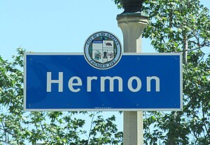
Hermon, Los Angeles
Neighborhood of Los Angeles in California, United States
Distance: Approx. 1056 meters
Latitude and longitude: 34.103906,-118.185077
Hermon is a neighborhood in the northeast area of Los Angeles. It was established in 1903 and became part of Los Angeles in 1912.
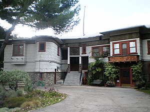
Pacific Christian on the Hill
Private, college-prep school in Los Angeles, California, United States
Distance: Approx. 971 meters
Latitude and longitude: 34.1029,-118.1826
Pacific Christian on the Hill was a small private college preparatory school located in the Hermon area of Los Angeles.

Highland Park station (Los Angeles Metro)
Los Angeles Metro Rail station
Distance: Approx. 1539 meters
Latitude and longitude: 34.1112,-118.1926
Highland Park station is an at-grade light rail station on the A Line of the Los Angeles Metro Rail system. It is located at the intersection of North Avenue 57 at Marmion Way (one block north of North Figueroa Street) in the Highland Park neighborhood of Los Angeles, after which the station is named. The station opened on July 26, 2003, as part of the original Gold Line, then known as the "Pasadena Metro Blue Line" project.

Cawston Ostrich Farm
Los Angeles tourist attraction (1886–1935)
Distance: Approx. 397 meters
Latitude and longitude: 34.1125,-118.17333333
Cawston Ostrich Farm, located in South Pasadena, California, United States, was opened in 1896 by Edwin Cawston. It was one of America's first ostrich farms and was located in the Arroyo Seco Valley just three miles (5 km) north of downtown Los Angeles and occupied nine acres. In 1887, the company built Hollywood's first railway, linking the farm to Hollywood.
Judson Studios
Stained glass studio in Los Angeles, California
Distance: Approx. 497 meters
Latitude and longitude: 34.11361111,-118.17861111
Judson Studios is a fine arts studio specializing in stained glass located in the Highland Park section (also known as Garvanza) of northeast Los Angeles. The stained glass studio was founded in the Mott Alley section of downtown Los Angeles in the mid-1890s by English-born artist William Lees Judson and his three sons. It moved to its current location in 1920 and remains in operation as a family-run business.

Pisgah Home Historic District
Historic district in California, United States
Distance: Approx. 988 meters
Latitude and longitude: 34.11055556,-118.18666667
Pisgah Home Historic District is a historic district in the Highland Park neighborhood of Los Angeles, California. It was the site of the Pisgah Home movement begun by faith healer and social reformer, Finis E. Yoakum, in the early 1900s. The site is closely aligned with the founding of the modern Pentecostal church.

Smith Estate (Los Angeles)
Historic house in California, United States
Distance: Approx. 1572 meters
Latitude and longitude: 34.11472222,-118.19194444
The Smith Estate, also known as El Mio (Spanish: "mine" or "my place"), is a historic Victorian house perched on a hilltop in the Highland Park section of Los Angeles, California. The street, El Mio, is named after the house, which is how the Smith family referred to it during their residence. Built in 1887, the house was designed in the Queen Anne style by Abram M. Edelman.

Highland Park Police Station
United States historic place
Distance: Approx. 1419 meters
Latitude and longitude: 34.11888889,-118.18666667
The Highland Park Police Station on York Boulevard in the Highland Park neighborhood of Los Angeles, California is the city's oldest surviving police station. Closed in 1983, the station is now operated as the Los Angeles Police Museum. It has been designated as a Historic Cultural Monument and listed on the National Register of Historic Places.
Rancho Huerta de Cuati
Mexican land grant in modern Los Angeles County, California
Distance: Approx. 1273 meters
Latitude and longitude: 34.12,-118.17
Rancho Huerta de Cuati was a 127-acre (0.51 km2) Mexican land grant in the San Rafael Hills area of present-day Los Angeles County, California given in 1838 by governor Juan Alvarado to Victoria Reid. The name means "Cuati Garden" in Spanish. The rancho included present-day Alhambra, San Marino, South Pasadena, and Pasadena—and Lake Wilson (now San Marino's Lacy Park).
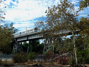
Santa Fe Arroyo Seco Railroad Bridge
Historic bridge in Los Angeles, USA
Distance: Approx. 784 meters
Latitude and longitude: 34.110958,-118.184373
The Santa Fe Arroyo Seco Railroad Bridge in Highland Park, Los Angeles, is more than 710 feet (220 m) long and crosses the Arroyo Seco Parkway at an elevation of over 56 feet (17 m). It is the tallest and longest railroad span in the city of Los Angeles, and most likely the oldest such structure still in use. The bridge crosses the lower part of the Arroyo Seco, a watershed canyon from the San Gabriel Mountains.
Los Angeles College Prep Academy
Charter school in Los Angeles, California, United States
Distance: Approx. 1030 meters
Latitude and longitude: 34.10266,-118.18325
Los Angeles College Prep Academy is a charter school in Hermon, Los Angeles, California, near El Sereno. It occupies the campus of the former Pacific Christian High School.
Budd Wiener Park
Distance: Approx. 1478 meters
Latitude and longitude: 34.0981,-118.1838
Budd Wiener Park is an urban park located in Los Angeles City Council District 14, Los Angeles, California. It consists of a grassy play area stocked with benches and drinking fountains.
Weather in this IP's area
clear sky
30 Celsius
30 Celsius
25 Celsius
34 Celsius
1008 hPa
40 %
1008 hPa
984 hPa
10000 meters
4.12 m/s
120 degree
06:30:56
19:10:29