199.247.193.241 - IP Lookup: Free IP Address Lookup, Postal Code Lookup, IP Location Lookup, IP ASN, Public IP
Country:
Region:
City:
Location:
Time Zone:
Postal Code:
ISP:
ASN:
language:
User-Agent:
Proxy IP:
Blacklist:
IP information under different IP Channel
ip-api
Country
Region
City
ASN
Time Zone
ISP
Blacklist
Proxy
Latitude
Longitude
Postal
Route
db-ip
Country
Region
City
ASN
Time Zone
ISP
Blacklist
Proxy
Latitude
Longitude
Postal
Route
IPinfo
Country
Region
City
ASN
Time Zone
ISP
Blacklist
Proxy
Latitude
Longitude
Postal
Route
IP2Location
199.247.193.241Country
Region
ontario
City
toronto
Time Zone
America/Toronto
ISP
Language
User-Agent
Latitude
Longitude
Postal
ipdata
Country
Region
City
ASN
Time Zone
ISP
Blacklist
Proxy
Latitude
Longitude
Postal
Route
Popular places and events near this IP address

Liberty Village
Neighbourhood in Toronto, Ontario, Canada
Distance: Approx. 339 meters
Latitude and longitude: 43.637,-79.422
Liberty Village is a neighbourhood in Toronto, Ontario, Canada. It is bordered to the north by King Street West, to the west by Dufferin Street, to the south by the Gardiner Expressway, to the east by Strachan Avenue, and to the northeast by railway tracks.

Drake Hotel (Toronto)
Hospitality venue in Toronto, Ontario
Distance: Approx. 553 meters
Latitude and longitude: 43.643197,-79.424661
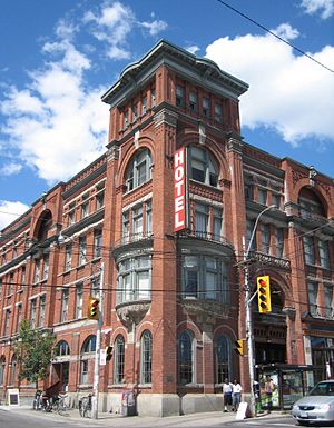
The Drake Hotel is a hospitality venue on Queen Street West in Toronto, Ontario, Canada, near Parkdale. In addition to a 51-room boutique hotel, there is a restaurant lounge, corner café with street-level patio, Sky Yard roof top patio, and the Drake Underground basement nightclub and live performance venue. The Drake Underground primarily features indie acts, though past noted performers include M.I.A., Billie Eilish and Beck.

Gladstone Hotel (Toronto)
Hotel in Toronto, Ontario
Distance: Approx. 497 meters
Latitude and longitude: 43.642683,-79.427
Gladstone House (formerly the Gladstone Hotel) is a boutique hotel at 1214 Queen Street West in the Parkdale area of Toronto, Ontario, Canada. Since renovations in the early 2000s, the hotel has become an arts hub in the West Queen West neighbourhood of Toronto. The hotel's restaurant and bar is located on the main floor and is known as Gladstone House Bistro + Bar.

St. John's Cathedral (Toronto)
Church in Ontario, Canada
Distance: Approx. 569 meters
Latitude and longitude: 43.63972222,-79.43258333
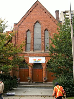
St. John's Cathedral Polish Catholic Church in the Parkdale area of Toronto, Ontario, is the seat of the Polish National Catholic Church's (PNCC) diocese in Canada.

Lamport Stadium
Rugby league stadium in Toronto, Canada
Distance: Approx. 231 meters
Latitude and longitude: 43.63888889,-79.42305556
Allan A. Lamport Stadium is a multi-purpose stadium on King Street West in the Liberty Village neighbourhood of Toronto, Ontario, Canada. It is the practice facility for the Toronto Argonauts of the Canadian Football League. It is also partial home for Canada national rugby league team.

Andrew Mercer Reformatory for Women
Prison in Canada
Distance: Approx. 231 meters
Latitude and longitude: 43.63888889,-79.42305556
The Andrew Mercer Reformatory for Women was a women's (16 years of age or older) prison in Toronto, Ontario, Canada. At various times, the facility was also known as the Mercer Complex, Andrew Mercer Reformatory for Females, and Andrew Mercer Ontario Reformatory for Females. Located on King Street West in Toronto, Ontario, the Mercer Reformatory opened in 1880.

Dufferin Gate Loop
Bus station and streetcar turning loop in Toronto, Ontario, Canada
Distance: Approx. 429 meters
Latitude and longitude: 43.63444444,-79.42583333
Dufferin Gate Loop, also known as Dufferin Loop, is a Toronto Transit Commission (TTC) bus station and turning loop for streetcars near the southern end of Dufferin Street in Toronto, Ontario, Canada. During the Canadian National Exhibition (CNE), the loop becomes a primary access point for visitors entering Exhibition Place via the Dufferin Gates. This west entrance to the CNE can be reached by the Dufferin Street bridges across the Lakeshore West railway corridor and Gardiner Expressway.
Epiphany and St. Mark, Parkdale
Church in Ontario, Canada
Distance: Approx. 602 meters
Latitude and longitude: 43.6407,-79.4325
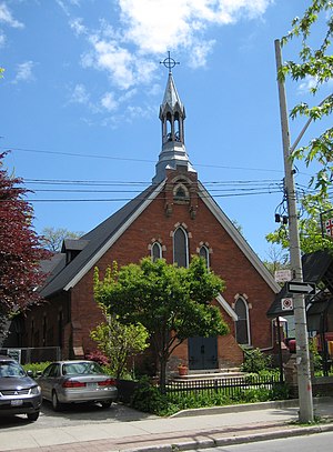
The Church of the Epiphany and St. Mark, Parkdale, is a small inclusive parish of the Anglican Church of Canada located in the Parkdale area of Toronto, Ontario. The church was founded upon the 1983 amalgamation of The Church of the Epiphany and The Church of St.

Dufferin Street bridges
Bridge in Ontario, Canada
Distance: Approx. 470 meters
Latitude and longitude: 43.634087,-79.425402
The Dufferin Street bridges are two inter-connected vehicular bridges in Toronto, Ontario, Canada. The bridges carry Dufferin Street over a railway corridor and the Gardiner Expressway to Exhibition Place. The bridges closed to vehicular traffic in 2013.

Parkdale station (Toronto)
Railway station in Toronto, Ontario, Canada
Distance: Approx. 428 meters
Latitude and longitude: 43.64194444,-79.4275
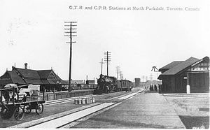
Parkdale railway station or North Parkdale railway station as it was also known was a passenger train station in Toronto, Ontario, Canada. The station served the Parkdale village on the then-outskirts of Toronto. The station served trains on the Northern Railway of Canada and Credit Valley Railway, later the Canadian Pacific Railway, railways.

Diamond Park (Toronto)
Former baseball stadium in Toronto, Canada
Distance: Approx. 216 meters
Latitude and longitude: 43.6373,-79.4235
Diamond Park was a baseball stadium in Toronto, Ontario, Canada. It was the home of the Toronto Maple Leafs professional baseball club from 1901 until 1907. It was located at the south-east corner of Liberty Street and Fraser Avenue.
King–Liberty GO Station
Planned commuter train station in Toronto
Distance: Approx. 327 meters
Latitude and longitude: 43.6409,-79.4239
King–Liberty GO Station (also referred to as Liberty Village) is a planned regional train station in Toronto, Ontario, Canada. It will be an infill station on the Kitchener line of GO Transit located between Union Station and Bloor GO Station. The station is one of five GO stations to be built as part of the SmartTrack Stations Program to adapt regional commuter service for urban public transit.
Weather in this IP's area
overcast clouds
-4 Celsius
-11 Celsius
-6 Celsius
-4 Celsius
1023 hPa
61 %
1023 hPa
1009 hPa
10000 meters
10.73 m/s
14.31 m/s
240 degree
100 %
