199.246.50.34 - IP Lookup: Free IP Address Lookup, Postal Code Lookup, IP Location Lookup, IP ASN, Public IP
Country:
Region:
City:
Location:
Time Zone:
Postal Code:
IP information under different IP Channel
ip-api
Country
Region
City
ASN
Time Zone
ISP
Blacklist
Proxy
Latitude
Longitude
Postal
Route
Luminati
Country
ASN
Time Zone
America/Toronto
ISP
S-I-S
Latitude
Longitude
Postal
IPinfo
Country
Region
City
ASN
Time Zone
ISP
Blacklist
Proxy
Latitude
Longitude
Postal
Route
IP2Location
199.246.50.34Country
Region
ontario
City
ottawa
Time Zone
America/Toronto
ISP
Language
User-Agent
Latitude
Longitude
Postal
db-ip
Country
Region
City
ASN
Time Zone
ISP
Blacklist
Proxy
Latitude
Longitude
Postal
Route
ipdata
Country
Region
City
ASN
Time Zone
ISP
Blacklist
Proxy
Latitude
Longitude
Postal
Route
Popular places and events near this IP address
Bell High School (Ottawa)
School in Ottawa, Ontario, Canada
Distance: Approx. 808 meters
Latitude and longitude: 45.32583333,-75.80972222
Bell High School is a high school located in the Bells Corners neighbourhood of Ottawa, Ontario, Canada. The school was established by the Carleton Board of Education in 1962 as a public high school for grades 9-13. In 2018, Bell High School became a 7-12 school after the nearby D. Aubrey Moodie Intermediate School closed down.

Queensway Carleton Hospital
Hospital in Ontario, Canada
Distance: Approx. 1231 meters
Latitude and longitude: 45.334818,-75.80767
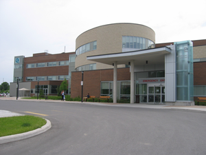
Queensway Carleton Hospital (QCH) is a 355-bed hospital located in the west end of Ottawa, Ontario, Canada that delivers acute care and is west Ottawa's only full-service hospital. QCH was officially opened on October 5, 1976, by then Ontario Premier William Davis and currently serves a population of more than 500,000 and is the secondary referral center for the Ottawa Valley. QCH focuses on its cornerstone health care programs: emergency, childbirth, Geriatric, mental health, rehabilitation, medical and surgical, and critical care.
Bells Corners
Community in Ontario, Canada
Distance: Approx. 1229 meters
Latitude and longitude: 45.32222222,-75.83333333
Bells Corners is a suburban neighbourhood in Ottawa, Ontario, Canada. It is located along Robertson Road west of downtown, within Ottawa's western Greenbelt, in College Ward. As of the 2021 Canadian census, the community had a population of 9,385.
Bayshore station (Ottawa)
Bus station in Ottawa, Canada
Distance: Approx. 2172 meters
Latitude and longitude: 45.34583333,-75.80944444
Bayshore is a station on the transitway in Ottawa, Ontario, served by OC Transpo buses. It is located in the western transitway section at the Bayshore Shopping Centre in the neighbourhood of Bayshore. Prior to its construction, buses used Woodridge Crescent and entered the shopping centre parking lot, which is prone to congestion and extensive delays.
Collège catholique Franco-Ouest
School in Ottawa, Ontario, Canada
Distance: Approx. 1849 meters
Latitude and longitude: 45.3147,-75.8344
Collège catholique Franco-Ouest is a French Catholic high school in the Nepean district of Ottawa, Ontario, Canada. It is located on 411 Seyton Drive in Bells Corners. It is an accredited school of the IB offering their middle and diploma programs.

College Ward
Place in Ontario, Canada
Distance: Approx. 671 meters
Latitude and longitude: 45.33333333,-75.81666667
College Ward or Ward 8 (French: Quartier Collège) is a city ward in Ottawa, Canada's west end. The ward covers the neighbourhoods of Bells Corners, Qualicum, Graham Park, Leslie Park, Redwood, Kenson Park, Parkway Park, Bel-Air Park, Bel-Air Heights, Braemar Park, Copeland Park, Briargreen, Centrepointe, Navaho, City View, Ryan Farm, Meadowlands and Crestview. Prior to the 2006 election, College Ward was known as Baseline Ward, and didn't include Bells Corners.
Qualicum-Graham Park
Distance: Approx. 1938 meters
Latitude and longitude: 45.33893,-75.80077
Qualicum-Graham Park or Qualicum is a suburban neighbourhood in College Ward in the City of Ottawa, Ontario, Canada. It is located in the former City of Nepean in the west end of the city. Many of the residences in the area are executive homes situated on large lots (100x100) being built in the 1960s.
Westcliffe Estates
Neighbourhood in Ottawa, Ontario, Canada
Distance: Approx. 1661 meters
Latitude and longitude: 45.31777778,-75.83555556
Westcliffe Estates (Bells Corners West), is a neighbourhood of Bells Corners in College Ward, in the west end of Ottawa, Ontario, Canada. Founded in 1969, most of the older homes in this area were built by Assaly Construction and later the Thomas C. Assaly Corporation. The Westcliffe community is characterized by significantly higher residential densities than other parts of Bells Corners.
Hartin's Hotel
Historic building in Ottawa, Ontario, Canada
Distance: Approx. 625 meters
Latitude and longitude: 45.325,-75.8267
The former Hartin's Hotel, currently the East India Company Restaurant and Conference Hall, is a historic building in the Bells Corners neighbourhood of Ottawa, Ontario, Canada.
Arbeatha Park
Distance: Approx. 1592 meters
Latitude and longitude: 45.31388889,-75.825
Arbeatha Park is a sub-neighbourhood of Lynwood Village, which is in turn a sub-neighbourhood of Bells Corners in the west end of Ottawa, Ontario, Canada. Bounded to the west is Moodie Drive, north is Old Richmond Road, east is Lynwood Village and south is a forest owned by the city of Ottawa. The neighbourhood is the second area to be developed in Bells Corners from 1955 to 1958.
Lynwood Village
Distance: Approx. 985 meters
Latitude and longitude: 45.319,-75.822
Lynwood Village is a neighbourhood in Bells Corners, west of Ottawa, Ontario, Canada. The neighbourhood is also known as Bells Corners East. The homes were built in between 1958 and 1966.

Bell Centennial Arena
Multi-purpose arena in Canada
Distance: Approx. 756 meters
Latitude and longitude: 45.325,-75.81083333
Bell Centennial Arena, also known as Bell Arena for short, is a multi-purpose arena in Bells Corners in Nepean, Ottawa, Ontario, Canada that is located behind Bell High School at 50 Cassidy Drive former Cedarview Road before the new Veterans Memorial Highway (Ontario Highway 416) was built.
Weather in this IP's area
broken clouds
-10 Celsius
-10 Celsius
-11 Celsius
-9 Celsius
1032 hPa
97 %
1032 hPa
1021 hPa
10000 meters
1.09 m/s
1.06 m/s
123 degree
67 %


