199.244.10.223 - IP Lookup: Free IP Address Lookup, Postal Code Lookup, IP Location Lookup, IP ASN, Public IP
Country:
Region:
City:
Location:
Time Zone:
Postal Code:
IP information under different IP Channel
ip-api
Country
Region
City
ASN
Time Zone
ISP
Blacklist
Proxy
Latitude
Longitude
Postal
Route
Luminati
Country
Region
oh
City
akron
ASN
Time Zone
America/New_York
ISP
BFRC
Latitude
Longitude
Postal
IPinfo
Country
Region
City
ASN
Time Zone
ISP
Blacklist
Proxy
Latitude
Longitude
Postal
Route
IP2Location
199.244.10.223Country
Region
ohio
City
columbus
Time Zone
America/New_York
ISP
Language
User-Agent
Latitude
Longitude
Postal
db-ip
Country
Region
City
ASN
Time Zone
ISP
Blacklist
Proxy
Latitude
Longitude
Postal
Route
ipdata
Country
Region
City
ASN
Time Zone
ISP
Blacklist
Proxy
Latitude
Longitude
Postal
Route
Popular places and events near this IP address

Ohio General Assembly
Legislative branch of the state government of Ohio
Distance: Approx. 88 meters
Latitude and longitude: 39.9616,-82.9987
The Ohio General Assembly is the state legislature of the U.S. state of Ohio. It consists of the 99-member Ohio House of Representatives and the 33-member Ohio Senate. Both houses of the General Assembly meet at the Ohio Statehouse in Columbus.

Ohio Statehouse
State capitol building of the U.S. state of Ohio
Distance: Approx. 101 meters
Latitude and longitude: 39.96138889,-82.99888889
The Ohio Statehouse is the state capitol building and seat of government for the U.S. state of Ohio. The Greek Revival building is located on Capitol Square in Downtown Columbus. The capitol houses the Ohio General Assembly, consisting of the House of Representatives and the Senate.
Preston Centre
Skyscraper in Columbus, Ohio
Distance: Approx. 130 meters
Latitude and longitude: 39.96226111,-82.99666694
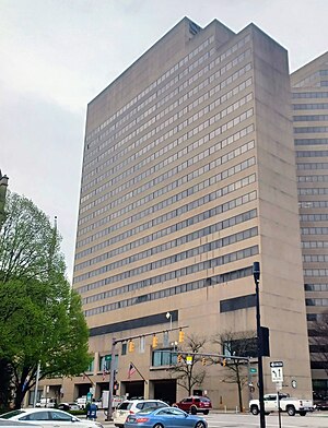
The Preston Centre is a 27-story, 317-foot (97 m) office building and skyscraper on Capitol Square in Downtown Columbus, Ohio. The Preston Centre is the 15th-tallest building in Columbus. The tower is named for Preston Wolfe, a former worker there.

United States Post Office and Courthouse (Columbus, Ohio)
Historic building in Columbus, Ohio
Distance: Approx. 152 meters
Latitude and longitude: 39.96013694,-82.99702889
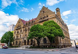
The United States Post Office and Courthouse is a historic building in Downtown Columbus, Ohio. The structure was built from 1884 to 1887 as the city's main post office. The building also served as a courthouse of the United States District Court for the Southern District of Ohio from its completion in 1887 until 1934, when the court moved to the Joseph P. Kinneary United States Courthouse.

Trinity Episcopal Church (Columbus, Ohio)
Historic church in Ohio, United States
Distance: Approx. 93 meters
Latitude and longitude: 39.96222222,-82.9975
Trinity Episcopal Church is a historic church on Capitol Square in Downtown Columbus, Ohio. It was built in 1866 and added to the National Register of Historic Places in 1976. The church features "The Church in the World", a stained glass window featuring Columbus landmarks and installed in 1965.

Ohio Veterans Plaza
Memorial plaza in Columbus, Ohio, U.S.
Distance: Approx. 35 meters
Latitude and longitude: 39.96144444,-82.99811111
Ohio Veterans Plaza is a memorial on the east side of the Ohio Statehouse grounds, in Columbus, Ohio, United States, commemorating "Ohio men and women who have served our country since World War II, as well as those who will serve in the future". Designed by John Schooley, the plaza features a lawn flanked by two Ohio limestone walls with inscriptions written by Ohio military personnel.

Naiads (Greaves)
Fountain and sculpture in Columbus, Ohio, U.S.
Distance: Approx. 135 meters
Latitude and longitude: 39.96023611,-82.998125
Naiads is a 1984 fountain and sculpture by Jack Greaves, installed by the Capitol Square skyscraper in Columbus, Ohio.

Capitol Square
Public square in Columbus, Ohio
Distance: Approx. 119 meters
Latitude and longitude: 39.961384,-82.999096
Capitol Square is a public square in Downtown Columbus, Ohio. The square includes the Ohio Statehouse, its 10-acre (4.0 ha) Capitol Grounds, as well as the buildings and features surrounding the square. The Capitol Grounds are surrounded to the north and west by Broad and High Streets.

Columbus Dispatch Building
Office building in Columbus, Ohio
Distance: Approx. 47 meters
Latitude and longitude: 39.96173,-82.99736
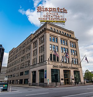
The Columbus Dispatch Building is a historic building on Capitol Square in Downtown Columbus, Ohio. The building was home to the Columbus Dispatch newspaper offices until January 2016, when it moved to 62 E. Broad St. on Capitol Square.

Griswold Memorial Young Women's Christian Association
United States historic place
Distance: Approx. 114 meters
Latitude and longitude: 39.961203,-82.996389
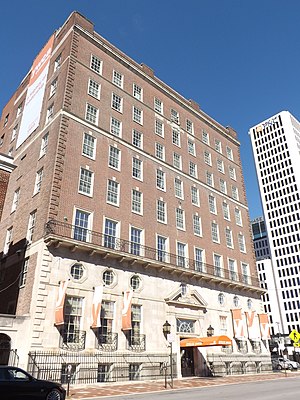
The Griswold Memorial Young Women's Christian Association, today known as the YWCA Center for Women, is a historic YWCA building in Downtown Columbus, Ohio. It was built in 1929 and was listed on the National Register of Historic Places in 1993. Renovations took place in 1963-64 and 1984.

The Plaza Hotel Columbus at Capitol Square
Highrise hotel in Downtown Columbus, Ohio
Distance: Approx. 153 meters
Latitude and longitude: 39.960031,-82.997808
The Plaza Hotel Columbus at Capitol Square is a high-rise hotel on Capitol Square in Downtown Columbus, Ohio. The hotel was constructed along with the Capitol Square skyscraper in the 1980s. The site was formerly home to the Hartman Building and Theater.

Hartman Building and Theater
Buildings in Columbus, Ohio
Distance: Approx. 136 meters
Latitude and longitude: 39.9602,-82.998
The Hartman Building and Theater was a pair of historic buildings on Capitol Square in Downtown Columbus, Ohio. The structures were commissioned by Samuel B. Hartman, designed by Richards, McCarty and Bulford in the Renaissance Revival style. The theater was demolished in 1971, followed by the office building in 1981.
Weather in this IP's area
clear sky
-6 Celsius
-11 Celsius
-7 Celsius
-5 Celsius
1027 hPa
76 %
1027 hPa
995 hPa
10000 meters
3.6 m/s
210 degree
