199.231.196.159 - IP Lookup: Free IP Address Lookup, Postal Code Lookup, IP Location Lookup, IP ASN, Public IP
Country:
 USA
USARegion:
City:
Location:
Time Zone:
Postal Code:
ISP:
ASN:
language:
User-Agent:
Proxy IP:
Blacklist:
IP information under different IP Channel
ip-api
Country
Region
City
ASN
Time Zone
ISP
Blacklist
Proxy
Latitude
Longitude
Postal
Route
db-ip
Country
Region
City
ASN
Time Zone
ISP
Blacklist
Proxy
Latitude
Longitude
Postal
Route
IPinfo
Country
Region
City
ASN
Time Zone
ISP
Blacklist
Proxy
Latitude
Longitude
Postal
Route
IP2Location
199.231.196.159Country
usRegion
pennsylvania
City
fort washington
Time Zone
America/New_York
ISP
Language
User-Agent
Latitude
Longitude
Postal
ipdata
Country
Region
City
ASN
Time Zone
ISP
Blacklist
Proxy
Latitude
Longitude
Postal
Route
Popular places and events near this IP address

Fort Washington, Pennsylvania
Census-designated place in Pennsylvania, United States
Distance: Approx. 1419 meters
Latitude and longitude: 40.13861111,-75.19138889
Fort Washington is a census-designated place and suburb of Philadelphia in Montgomery County, Pennsylvania, United States. The CDP, as of 2020, is entirely in Upper Dublin Township. The population was 5,446 at the 2010 census.
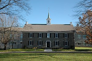
Germantown Academy
Private school in Fort Washington, Pennsylvania, United States
Distance: Approx. 1030 meters
Latitude and longitude: 40.137514,-75.220106
Germantown Academy, informally known as GA and originally known as the Union School, is the oldest nonsectarian day school in the United States. The school was founded on December 6, 1759, by a group of prominent Germantown citizens in the Green Tree Tavern on the Germantown Road. Germantown Academy enrolls students from pre-kindergarten to 12th grade and is located in the Philadelphia suburb of Fort Washington, having moved from its original Germantown campus in 1965.
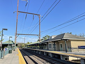
Fort Washington station
Distance: Approx. 379 meters
Latitude and longitude: 40.1354,-75.2115
Fort Washington station is a station along the SEPTA Lansdale/Doylestown Line. The station is located at the intersection of Bethlehem Pike and Station Avenue in the Fort Washington section of Whitemarsh Township, Pennsylvania. It is also served by SEPTA Bus Routes 94, 95, and 201, as well as OurBus intercity buses to New York City.

Hope Lodge (Whitemarsh Township, Pennsylvania)
Historic house in Pennsylvania, United States
Distance: Approx. 1579 meters
Latitude and longitude: 40.124996,-75.216758
Hope Lodge is a historic building located at 553 South Bethlehem Pike in Fort Washington, Pennsylvania, in the United States. This mansion has been described as "one of the finest examples of Georgian Colonial architecture in this part of the country. It was used by Continental troops during the 1777 Philadelphia Campaign during the American Revolution.

Clifton House, Pennsylvania
Historic building in Fort Washington, Pennsylvania
Distance: Approx. 721 meters
Latitude and longitude: 40.13305556,-75.21416667
Clifton House, previously known as Sandy Tavern, is a historic building located at 473 Bethlehem Pike in Fort Washington, Pennsylvania. During the autumn of 1777, George Washington's Continental Army spent six weeks camped at nearby Whitemarsh. Colonels Clement Biddle (the "Quaker General" and member of one of Philadelphia's prominent families) and Stephen Moylan, and General George Wheedon, were quartered here during the encampment.

Great Train Wreck of 1856
1856 railroad accident in Pennsylvania
Distance: Approx. 1061 meters
Latitude and longitude: 40.12879444,-75.20293333
The Great Train Wreck of 1856 occurred in Whitemarsh Township, Pennsylvania, between Camp Hill station (known as Sandy Run, Camp Hill, Sellwick and finally Fellwick station before being closed in 1996) and Fort Washington station, on July 17, 1856. Two trains, traveling on the same track in converging directions, collided, killing between 59 and 67, and injuring over 100. The incident was referred to as The Camp Hill Disaster in Montgomery County, and The Picnic Train Tragedy in Philadelphia.

Union School (Fort Washington, Pennsylvania)
United States historic place
Distance: Approx. 1324 meters
Latitude and longitude: 40.12861111,-75.21833333
The Union School is an historic, American building that is located at 516-518 Bethlehem Pike in the Fort Washington section of Whitemarsh Township, Pennsylvania. The Union School has been listed on the U.S. National Register of Historic Places since 1980.

Sandy Run (Wissahickon Creek tributary)
River in United States of America
Distance: Approx. 1342 meters
Latitude and longitude: 40.1301097,-75.2204546
Sandy Run is a second-order stream (according to the Strahler stream order) that is a tributary to the Wissahickon Creek at Fort Washington State Park. The headwaters are in Dresher and Roslyn, Pennsylvania, and the stream flows west for approximately 6 miles (9.7 km). The stream follows through Abington, Upper Dublin, Springfield, and Whitemarsh Townships; and flows through several golf courses, including Sandy Run Country Club, Lu Lu Country Club, and Manufacturers Country Club.
St. Paul's United Church of Christ
Distance: Approx. 543 meters
Latitude and longitude: 40.13541,-75.21377
St. Paul's United Church of Christ is a United Church of Christ church in Fort Washington, Pennsylvania.

County Bridge No. 54
United States historic place
Distance: Approx. 791 meters
Latitude and longitude: 40.13944444,-75.21694444
County Bridge No. 54 is a historic stone arch bridge located near Prospectville in Whitemarsh Township, Montgomery County, Pennsylvania. The bridge was built in 1841 and rebuilt in 1916.

Fellwick station
Distance: Approx. 1619 meters
Latitude and longitude: 40.124528,-75.199395
Fellwick station was a SEPTA Regional Rail station in Springfield Township, Montgomery County, Pennsylvania. Located near the intersection of Camp Hill and Walnut Avenue, Fellwick was a station on the R5 Lansdale/Doylestown Line. Opened originally in 1855 as Sandy Run, Fellwick station was the site of the Great Train Wreck of 1856, which claimed the lives of approximately 60 people.

Lindenwold Castle
Castle in Ambler, Pennsylvania
Distance: Approx. 1486 meters
Latitude and longitude: 40.150373,-75.21264
Lindenwold Castle, also known as the Mattison Estate, is the former personal estate in Ambler, Pennsylvania, United States of asbestos magnate Richard Van Zeelust Mattison (1851–1935) of the Keasbey and Mattison Company. It was designed by Milton Bean and built in 1890.
Weather in this IP's area
mist
-1 Celsius
-3 Celsius
-2 Celsius
0 Celsius
1024 hPa
91 %
1024 hPa
1014 hPa
8047 meters
2.06 m/s
50 degree
100 %