199.231.179.251 - IP Lookup: Free IP Address Lookup, Postal Code Lookup, IP Location Lookup, IP ASN, Public IP
Country:
 USA
USARegion:
City:
Location:
Time Zone:
Postal Code:
ISP:
ASN:
language:
User-Agent:
Proxy IP:
Blacklist:
IP information under different IP Channel
ip-api
Country
Region
City
ASN
Time Zone
ISP
Blacklist
Proxy
Latitude
Longitude
Postal
Route
db-ip
Country
Region
City
ASN
Time Zone
ISP
Blacklist
Proxy
Latitude
Longitude
Postal
Route
IPinfo
Country
Region
City
ASN
Time Zone
ISP
Blacklist
Proxy
Latitude
Longitude
Postal
Route
IP2Location
199.231.179.251Country
usRegion
pennsylvania
City
langhorne
Time Zone
America/New_York
ISP
Language
User-Agent
Latitude
Longitude
Postal
ipdata
Country
Region
City
ASN
Time Zone
ISP
Blacklist
Proxy
Latitude
Longitude
Postal
Route
Popular places and events near this IP address
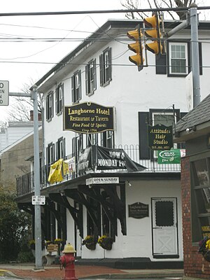
Langhorne, Pennsylvania
Borough in Pennsylvania, United States
Distance: Approx. 2475 meters
Latitude and longitude: 40.1775,-74.91888889
Langhorne Borough, formerly known as Attleboro, is a borough in Bucks County, Pennsylvania, United States. The population was 1,643 at the time of the 2020 census. The mailing address "Langhorne" is used for Langhorne Borough, but it is also used broadly to describe the majority of surrounding Middletown Township, which for the most part uses Langhorne's ZIP code of 19047.

Langhorne Manor, Pennsylvania
Borough in Pennsylvania, United States
Distance: Approx. 2093 meters
Latitude and longitude: 40.16583333,-74.91777778
Langhorne Manor is a borough in Bucks County, Pennsylvania, United States. The population was 1,422 at the 2010 census, a 55.6% increase from the 2000 census. The mayor of Langhorne Manor is Bob Byrne.

Neshaminy High School
Public school in Pennsylvania, US
Distance: Approx. 877 meters
Latitude and longitude: 40.1567,-74.945
Neshaminy High School is a public high school in Middletown Township (Langhorne post office address) in Bucks County, Pennsylvania, United States. It is the only high school in the Neshaminy School District, serving students in Middletown Township, Lower Southampton Township, Hulmeville, Langhorne, Langhorne Manor, and Penndel. In 2022, the school enrolled 2,677 students in grades 9 through 12.

Growden Mansion
Historic house in Pennsylvania, United States
Distance: Approx. 1960 meters
Latitude and longitude: 40.14741944,-74.93575833
Growdon Mansion, also known as Trevose Manor, is a local historical landmark in Bensalem Township, Pennsylvania, United States. It played an important role in early Bucks County history. The mansion sits along the Neshaminy Creek in Bensalem, a township that borders the northeast section of Philadelphia, in the northeastern United States.
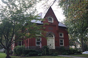
Langhorne Library
United States historic place
Distance: Approx. 2024 meters
Latitude and longitude: 40.17527778,-74.92333333
The Langhorne Library is an historic, American library building that is located in Langhorne, Bucks County, Pennsylvania. It was added to the National Register of Historic Places in 1986, is located in the Langhorne Historic District, which was added to the register in 1987.

Joseph Richardson House (Langhorne, Pennsylvania)
Historic house in Pennsylvania, United States
Distance: Approx. 2291 meters
Latitude and longitude: 40.17583333,-74.92
The Joseph Richardson House, also known as the Langhorne Community Memorial Building, is an historic American home that is located in Langhorne, Bucks County, Pennsylvania. Located in the Langhorne Historic District, it was added to the National Register of Historic Places in 1985.

Tomlinson-Huddleston House
Historic house in Pennsylvania, United States
Distance: Approx. 2212 meters
Latitude and longitude: 40.17611111,-74.92138889
The Tomlinson-Huddleston House, also known as The Signature House, is an historic, American home that is located in Langhorne, Bucks County, Pennsylvania. Now part of the Langhorne Historic District, it was added to the National Register of Historic Places in 1983.

Langhorne Manor School
United States historic place
Distance: Approx. 1803 meters
Latitude and longitude: 40.16444444,-74.92111111
The Langhorne Manor School, now known as Langhorne Manor Borough Hall, is an historic, American one-room school building that is located in Langhorne Manor, Bucks County, Pennsylvania. It was added to the National Register of Historic Places in 2008.

Langhorne Historic District
Historic district in Pennsylvania, United States
Distance: Approx. 2213 meters
Latitude and longitude: 40.17583333,-74.92111111
The Langhorne Historic District, also known as "Attleborough," is a national historic district that is located in Langhorne, Bucks County, Pennsylvania. It was added to the National Register of Historic Places in 1986.

Neshaminy Falls, Pennsylvania
Unincorporated community in Pennsylvania, United States
Distance: Approx. 1902 meters
Latitude and longitude: 40.15333333,-74.95944444
Neshaminy Falls is an unincorporated community in Bensalem Township in Bucks County, Pennsylvania, United States. Neshaminy Falls is located in the northwestern part of the township, southwest of Bristol Road. It is served by the Neshaminy Falls station on SEPTA's West Trenton Line.
Mill Creek (Neshaminy Creek tributary, Northampton Township)
River in Pennsylvania, United States
Distance: Approx. 2037 meters
Latitude and longitude: 40.17861111,-74.95722222
Mill Creek is a tributary of Neshaminy Creek rising in Upper Southampton Township in Bucks County, Pennsylvania, United States. It is one of at least six creeks in Bucks County bearing the same name. The upper portion of Mill Creek was formerly known as Broad Axe Creek.
Pine Run (Mill Creek, Neshaminy Creek tributary)
River in Pennsylvania, United States
Distance: Approx. 2183 meters
Latitude and longitude: 40.17888889,-74.95944444
Pine Creek is a tributary of Mill Creek, which, in turn, is a tributary of the Neshaminy Creek, part of the Delaware River watershed.
Weather in this IP's area
clear sky
-3 Celsius
-6 Celsius
-4 Celsius
-2 Celsius
1027 hPa
56 %
1027 hPa
1021 hPa
10000 meters
1.54 m/s
350 degree