199.216.187.43 - IP Lookup: Free IP Address Lookup, Postal Code Lookup, IP Location Lookup, IP ASN, Public IP
Country:
Region:
City:
Location:
Time Zone:
Postal Code:
ISP:
ASN:
language:
User-Agent:
Proxy IP:
Blacklist:
IP information under different IP Channel
ip-api
Country
Region
City
ASN
Time Zone
ISP
Blacklist
Proxy
Latitude
Longitude
Postal
Route
db-ip
Country
Region
City
ASN
Time Zone
ISP
Blacklist
Proxy
Latitude
Longitude
Postal
Route
IPinfo
Country
Region
City
ASN
Time Zone
ISP
Blacklist
Proxy
Latitude
Longitude
Postal
Route
IP2Location
199.216.187.43Country
Region
alberta
City
medicine hat
Time Zone
America/Edmonton
ISP
Language
User-Agent
Latitude
Longitude
Postal
ipdata
Country
Region
City
ASN
Time Zone
ISP
Blacklist
Proxy
Latitude
Longitude
Postal
Route
Popular places and events near this IP address

Medicine Hat
City in Alberta, Canada
Distance: Approx. 1192 meters
Latitude and longitude: 50.04083333,-110.67666667
Medicine Hat is a city in southeast Alberta, Canada. It is located along the South Saskatchewan River. It is approximately 169 km (105 mi) east of Lethbridge and 295 km (183 mi) southeast of Calgary.

Medicine Hat (provincial electoral district)
Defunct provincial electoral district in Alberta, Canada
Distance: Approx. 1903 meters
Latitude and longitude: 50.06,-110.69
Medicine Hat was a provincial electoral district in Alberta, Canada, mandated to return members to the Legislative Assembly of Alberta from 1905 to 1971, and again from 1979 to 2019. The electoral district was named after the City of Medicine Hat.
Medicine Hat Arena
Multi-purpose arena in Alberta, Canada
Distance: Approx. 696 meters
Latitude and longitude: 50.0439,-110.6696
The Medicine Hat Arena is a 4,006-seat multi-purpose arena in Medicine Hat, Alberta, Canada. It was built in 1970 to replace Arena Gardens (Medicine Hat), the old rink that burned down in a fire where the Medicine Hat Inn is now situated. It was home to the Medicine Hat Tigers ice hockey team.

Division No. 1, Alberta
Census division in Alberta, Canada
Distance: Approx. 1870 meters
Latitude and longitude: 50.03333333,-110.66666667
Division No. 1 is a census division in Alberta, Canada. It is located in the southeast corner of southern Alberta and surrounds the City of Medicine Hat.

Athletic Park (Medicine Hat)
Stadium in Medicine Hat, Alberta, Canada
Distance: Approx. 603 meters
Latitude and longitude: 50.044849,-110.666206
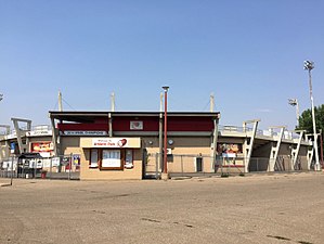
Athletic Park is a stadium in Medicine Hat, Alberta, Canada. It is primarily used for baseball and was the home of the Medicine Hat Blue Jays of the Pioneer League and home to the Medicine Hat Mavericks of the Western Canadian Baseball League since 2002. The ballpark has a capacity of 2200 people and was opened in 1978.
Medicine Hat Public School Division
School district in Alberta, Canada
Distance: Approx. 2492 meters
Latitude and longitude: 50.03333333,-110.69138889
Medicine Hat Public School Division (MHPSD), formerly known as Medicine Hat Public School District No. 76, is the public school board in Medicine Hat, Alberta, Canada.

Medicine Hat Public Library
Distance: Approx. 1393 meters
Latitude and longitude: 50.04059,-110.68096
Medicine Hat Public Library (MHPL) is a public library located in Medicine Hat, Alberta, Canada. It overlooks the beautiful South Saskatchewan River, on Treaty 7, Treaty 4, and Métis Nation Region 3 territory. MHPL is a member of the Shortgrass Library System and The Alberta Library.
Crescent Heights High School (Medicine Hat)
Public junior/senior high school in Medicine Hat, Alberta, Canada
Distance: Approx. 1375 meters
Latitude and longitude: 50.053,-110.687
Crescent Heights High School is a public high school with approximately 1,300 students in grades 7–12 in Medicine Hat, Alberta. The school is part of the Medicine Hat School District No. 76 and is one of four high schools in the city of Medicine Hat, Alberta supporting a population of some 60,000 people.
Medicine Hat High School
Senior high school in Medicine Hat, Alberta, Canada
Distance: Approx. 2527 meters
Latitude and longitude: 50.03293,-110.69143
Medicine Hat High School is a public secondary school of 1227 students as of the 2022–23 school year. It is located in Medicine Hat, Alberta, Canada. It is a member of School District 76 (SD76), Medicine Hat's main public district and has the largest capacity of all schools within Medicine Hat MHHS was originally built in 1952.

Medicine Hat Regional Hospital
Hospital in Alberta, Canada
Distance: Approx. 2917 meters
Latitude and longitude: 50.03527778,-110.70194444
Medicine Hat Regional Hospital is a medical facility located in Medicine Hat, Alberta serving a catchment area of 117,000. It has 213 beds. Alberta Health Services is responsible for the operations of the hospital.

Medalta Potteries
Canadian ceramics manufacturing company
Distance: Approx. 2444 meters
Latitude and longitude: 50.03166667,-110.64972222
The Medalta Potteries was a Canadian ceramics manufacturing company in Medicine Hat, Alberta, that operated from 1916 to 1954. It was the first manufacturer in Western Canada to ship its products east of Ontario.

Medicine Hat station
Distance: Approx. 1182 meters
Latitude and longitude: 50.0397,-110.6716
Medicine Hat station is a heritage railway station in Medicine Hat, Alberta. It was built by the Canadian Pacific Railway in 1906 and expanded in 1911–1912, using red brick from Medicine Hat and sandstone from Calgary.
Weather in this IP's area
overcast clouds
2 Celsius
-3 Celsius
2 Celsius
2 Celsius
1019 hPa
55 %
1019 hPa
931 hPa
10000 meters
6.69 m/s
10.8 m/s
270 degree
100 %