Country:
Region:
City:
Latitude and Longitude:
Time Zone:
Postal Code:
IP information under different IP Channel
ip-api
Country
Region
City
ASN
Time Zone
ISP
Blacklist
Proxy
Latitude
Longitude
Postal
Route
Luminati
Country
Region
mn
City
duluth
ASN
Time Zone
America/Chicago
ISP
COMPISP
Latitude
Longitude
Postal
IPinfo
Country
Region
City
ASN
Time Zone
ISP
Blacklist
Proxy
Latitude
Longitude
Postal
Route
db-ip
Country
Region
City
ASN
Time Zone
ISP
Blacklist
Proxy
Latitude
Longitude
Postal
Route
ipdata
Country
Region
City
ASN
Time Zone
ISP
Blacklist
Proxy
Latitude
Longitude
Postal
Route
Popular places and events near this IP address

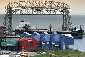
Aerial Lift Bridge
Transporter bridge in Duluth, Minnesota
Distance: Approx. 1365 meters
Latitude and longitude: 46.77902778,-92.09275
The Aerial Lift Bridge, earlier known as the Aerial Bridge or Aerial Ferry Bridge, is a landmark in the port city of Duluth, Minnesota. The span began life in 1905 as the United States' first transporter bridge: Only one other was ever constructed in the country, Sky Ride in Chicago. The span was converted in 1929–1930 to a vertical-lift bridge, also rather uncommon, although there are six such bridges along Ontario's Welland Canal.

USCGC Sundew
U.S. Coast Guard cutter
Distance: Approx. 1449 meters
Latitude and longitude: 46.77633333,-92.10444444
USCGC Sundew (WLB-404) was a 180-foot (55 m) sea going buoy tender (WLB). An Iris, or C-class tender, it was built by Marine Iron and Shipbuilding Corporation in Duluth, Minnesota, United States. Sundew's preliminary design was completed by the United States Lighthouse Service and the final design was produced by Marine Iron and Shipbuilding Corporation in Duluth for the U.S. Coast Guard.

Duluth Entertainment Convention Center
Arena & convention center in Duluth, MN
Distance: Approx. 1699 meters
Latitude and longitude: 46.78138889,-92.09805556
Duluth Entertainment Convention Center (DECC) is a multi-purpose arena and convention center complex located in Duluth, Minnesota. It was home to the University of Minnesota Duluth Bulldogs men's hockey team from 1966-2010. The DECC is located on the waterfront near Duluth's famous Aerial Lift Bridge.

Canal Park, Duluth, Minnesota
District of Duluth, Minnesota, United States
Distance: Approx. 1505 meters
Latitude and longitude: 46.78027778,-92.09305556
Canal Park is a tourist and recreation-oriented district of Duluth, Minnesota, United States. Situated across the Interstate 35 freeway from Downtown Duluth, it is connected by the Aerial Lift Bridge across the Duluth Ship Canal to the Park Point sandbar and neighborhood. Canal Park Drive and Lake Avenue South serve as the main routes in Canal Park.

Great Lakes Aquarium
Public aquarium in Duluth, Minnesota, United States
Distance: Approx. 1541 meters
Latitude and longitude: 46.77926667,-92.10027778
The Great Lakes Aquarium opened in 2000 and is located on the Duluth waterfront. A 501(c)(3) private nonprofit, Great Lakes Aquarium features animals and habitats found within the Great Lakes basin and other worldwide ecosystems such as the Amazon River or Pacific reefs. The aquarium houses 205 different species of fish, birds, reptiles, amphibians, and mammals.

Lake Superior Maritime Visitor Center
Maritime museum in Duluth, Minnesota
Distance: Approx. 1455 meters
Latitude and longitude: 46.77986111,-92.09236111
The Lake Superior Maritime Visitor Center is a museum in Duluth, Minnesota, operated by the United States Army Corps of Engineers.

U.S. Army Corps of Engineers Duluth Vessel Yard
United States historic place
Distance: Approx. 980 meters
Latitude and longitude: 46.77555556,-92.09277778
The U.S. Army Corps of Engineers Duluth Vessel Yard is a federal port facility in Duluth, Minnesota, United States. It houses the United States Army Corps of Engineers (USACE) resources used to maintain the harbors of the Twin Ports of Duluth and Superior, Wisconsin. It was established on Minnesota Point in 1903, though most of its present configuration dates to a flurry of construction in 1941.

AMSOIL Arena
Distance: Approx. 1699 meters
Latitude and longitude: 46.78138889,-92.09805556
AMSOIL Arena is a multipurpose arena in Duluth, Minnesota, home to the UMD Men's and UMD Women's hockey teams. It opened in 2010, replacing the DECC Arena on the waterfront near Duluth's landmark Aerial Lift Bridge. Naming rights for 20 years were purchased by AMSOIL, a corporation based in Superior, Wisconsin, for $6 million, one-third up front.

Duluth Harbor North Pier Light
Lighthouse
Distance: Approx. 1594 meters
Latitude and longitude: 46.78094444,-92.08827778
The Duluth Harbor North Pier Light is a lighthouse on the north breakwater of the Duluth Ship Canal in Duluth, Minnesota, United States.

Duluth Ship Canal
Distance: Approx. 1408 meters
Latitude and longitude: 46.77944444,-92.09138889
The Duluth Ship Canal is an artificial canal cut through Minnesota Point, providing direct access to Duluth harbor from Lake Superior. Begun privately in 1871, it was put under federal supervision and maintenance several years later. It is still an important component of the harbor facilities.

Duluth South Breakwater Inner Light
Lighthouse
Distance: Approx. 1328 meters
Latitude and longitude: 46.77872222,-92.09202778
The Duluth South Breakwater Inner Light is a lighthouse on the south breakwater of the Duluth Ship Canal in Duluth, Minnesota, United States. It forms a range with the Duluth South Breakwater Outer Light to guide ships into the canal from Lake Superior. The current structure was built from 1900 to 1901.

Duluth South Breakwater Outer Light
Lighthouse
Distance: Approx. 1506 meters
Latitude and longitude: 46.78008333,-92.08777778
The Duluth South Breakwater Outer Light is a lighthouse on the south breakwater of the Duluth Ship Canal in Duluth, Minnesota, United States. It forms a range with the Duluth South Breakwater Inner Light to guide ships into the canal from Lake Superior.
Weather in this IP's area
overcast clouds
8 Celsius
3 Celsius
6 Celsius
8 Celsius
1005 hPa
76 %
1005 hPa
983 hPa
10000 meters
11.32 m/s
15.43 m/s
60 degree
100 %
07:16:12
16:31:25