199.21.158.250 - IP Lookup: Free IP Address Lookup, Postal Code Lookup, IP Location Lookup, IP ASN, Public IP
Country:
Region:
City:
Location:
Time Zone:
Postal Code:
ISP:
ASN:
language:
User-Agent:
Proxy IP:
Blacklist:
IP information under different IP Channel
ip-api
Country
Region
City
ASN
Time Zone
ISP
Blacklist
Proxy
Latitude
Longitude
Postal
Route
db-ip
Country
Region
City
ASN
Time Zone
ISP
Blacklist
Proxy
Latitude
Longitude
Postal
Route
IPinfo
Country
Region
City
ASN
Time Zone
ISP
Blacklist
Proxy
Latitude
Longitude
Postal
Route
IP2Location
199.21.158.250Country
Region
california
City
orange
Time Zone
America/Los_Angeles
ISP
Language
User-Agent
Latitude
Longitude
Postal
ipdata
Country
Region
City
ASN
Time Zone
ISP
Blacklist
Proxy
Latitude
Longitude
Postal
Route
Popular places and events near this IP address

North Tustin, California
Place in California, United States
Distance: Approx. 2730 meters
Latitude and longitude: 33.765,-117.79916667
North Tustin is an unincorporated community and census designated place (CDP) in Orange County, California. The population was 25,718 at the 2020 census, up from 24,917 in 2010. For statistical purposes, the United States Census Bureau has defined North Tustin as a census-designated place (CDP).

Villa Park, California
City in California, United States
Distance: Approx. 3371 meters
Latitude and longitude: 33.81611111,-117.81111111
Villa Park is a city in northern Orange County, California, United States. It was founded in 1962. At the 2010 census, the city had a population of 5,812, making it the smallest city in Orange County.
Santiago Canyon College
Public community college in Orange, California, US
Distance: Approx. 2695 meters
Latitude and longitude: 33.7956,-117.7663
Santiago Canyon College is a public community college in Orange, California. Along with Santa Ana College, Santiago Canyon College is one of two campuses in the Rancho Santiago Community College District (RSCCD).
KWIZ
Radio station in Santa Ana, California
Distance: Approx. 1433 meters
Latitude and longitude: 33.802,-117.796
KWIZ (96.7 FM) is a commercial radio station licensed to Santa Ana, California, and broadcasting to the Los Angeles-Orange County area. KWIZ airs a Spanish Christian radio format branded as "Vision Latina 96.7 FM". It is currently owned by the Universal Church with studios and offices are on West 5th Street in Santa Ana.
Foothill High School (Orange County, California)
Public school in Santa Ana, California , United States
Distance: Approx. 2449 meters
Latitude and longitude: 33.767411,-117.798071
Foothill High School is a public secondary school located in the unincorporated community of North Tustin, California. It has a mailing address of Santa Ana, but it is a part of the Tustin Unified School District.

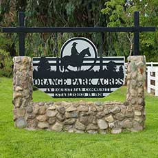
Orange Park Acres, California
Unincorporated community in Orange County, California, United States
Distance: Approx. 1860 meters
Latitude and longitude: 33.80194,-117.78139
Orange Park Acres is an unincorporated community and census designated place (CDP) surrounded by the city of Orange in Orange County, California. Orange Park Acres is bordered by Santiago Canyon Road to the north and Chapman Avenue to the South. It comprises approximately 5,500 residents and is about 1.4 square miles (3.6 km2) in size.

El Modena, California
Unincorporated area and neighborhood in Orange County, California
Distance: Approx. 1324 meters
Latitude and longitude: 33.78778,-117.80861
El Modena is an unincorporated community and census designated place (CDP) surrounding El Modena High School and within the city of Orange, California and the surrounding unincorporated county area. It is located near and east of the intersection of Hewes Street and Chapman Avenue. Much of the area was annexed by Orange in the 1960s and 1970s, but there are still enclaves of unincorporated county land to the east of the high school.

El Modena High School
Public school in Orange, California
Distance: Approx. 1640 meters
Latitude and longitude: 33.789634,-117.812115
El Modena High School, colloquially called El Mo or ElMo, is a traditional four-year public high school located in the El Modena neighborhood of the City of Orange in Orange County, California. It is one of four high schools in the Orange Unified School District, along with Villa Park High School, Orange High School, and Canyon High School. Founded in 1966, its first class graduated in June 1968, the school celebrated its 50th anniversary during the 2016–17 school year.
Rancho Lomas de Santiago
Distance: Approx. 2176 meters
Latitude and longitude: 33.77,-117.79
Rancho Lomas de Santiago was a 47,227-acre (191 km2) Mexican land grant given by Mexican Governor Pío Pico to Teodosio Yorba in 1846. The name means "Hills of St. James".
Peters Canyon
Valley in California, United States of America
Distance: Approx. 3024 meters
Latitude and longitude: 33.7841,-117.7623
Peters Canyon Regional Park is a regional park within the Orange County Regional Parks System in California. The park contains 354 acres of southern California wildlife, including coastal sage shrub, riparian, freshwater marsh, and grasslands, and is located within the boundaries of both Orange, California and Tustin, California. Peters Canyon was given to this city in 1992 by the Irvine Company who had used it previously for cattle grazing.
Eldorado Emerson Private School
Private school in Orange, California, United States
Distance: Approx. 1521 meters
Latitude and longitude: 33.79455562,-117.80953077
Eldorado Emerson Private School (also known as Eldorado School and Emerson Choice Academy) was a co-educational private school in El Modena, Orange, California, United States. It was established in 1959 as a school for the gifted by Glory Ludwick. It closed permanently in June 2020.
Serrano Water District
Distance: Approx. 3007 meters
Latitude and longitude: 33.80820228,-117.81750559
The Serrano Water District is a California special district that maintains the groundwater of parts of eastern Orange County. The agency serves a 4.7 square mile area that encompasses the entirety of Villa Park and a small portion of Orange. The population served is approximately 6,500.
Weather in this IP's area
clear sky
10 Celsius
8 Celsius
7 Celsius
12 Celsius
1011 hPa
31 %
1011 hPa
994 hPa
10000 meters
0.45 m/s
0.89 m/s
