199.21.158.236 - IP Lookup: Free IP Address Lookup, Postal Code Lookup, IP Location Lookup, IP ASN, Public IP
Country:
Region:
City:
Location:
Time Zone:
Postal Code:
ISP:
ASN:
language:
User-Agent:
Proxy IP:
Blacklist:
IP information under different IP Channel
ip-api
Country
Region
City
ASN
Time Zone
ISP
Blacklist
Proxy
Latitude
Longitude
Postal
Route
db-ip
Country
Region
City
ASN
Time Zone
ISP
Blacklist
Proxy
Latitude
Longitude
Postal
Route
IPinfo
Country
Region
City
ASN
Time Zone
ISP
Blacklist
Proxy
Latitude
Longitude
Postal
Route
IP2Location
199.21.158.236Country
Region
california
City
santa ana
Time Zone
America/Los_Angeles
ISP
Language
User-Agent
Latitude
Longitude
Postal
ipdata
Country
Region
City
ASN
Time Zone
ISP
Blacklist
Proxy
Latitude
Longitude
Postal
Route
Popular places and events near this IP address

Orange Crush interchange
Interchange in California
Distance: Approx. 1589 meters
Latitude and longitude: 33.7801,-117.8792
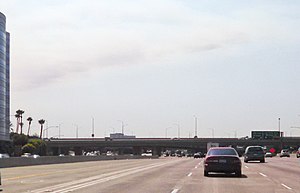
The Orange Crush interchange, frequently called The Crush, is a freeway interchange in the cities of Orange and Santa Ana, California, near the city limits of the cities of Anaheim, and Garden Grove. The Disneyland Resort, The Outlets at Orange, St. Joseph Hospital, Children's Hospital of Orange County, the UCI Medical Center, Westfield MainPlace, Angel Stadium of Anaheim, Honda Center, Platinum Triangle and the Lamaroux Justice Center of the Superior Court of California of the County of Orange are all located at or near the interchange.

Bowers Museum
Art museum, cultural art in Santa Ana, California
Distance: Approx. 1541 meters
Latitude and longitude: 33.76331,-117.8682
The Bowers Museum is an art museum located in Santa Ana, California. The museum's permanent collection includes more than 100,000 objects, and features notable strengths in the areas of pre-Columbian Mesoamerica, Native American art, the art of Asia, Africa, and Oceania, and California plein-air painting. The Bowers organizes and hosts special exhibitions from institutions throughout the world, and travels exhibitions nationally and internationally.
California Coast University
Private for-profit online university in Santa Ana, California
Distance: Approx. 1880 meters
Latitude and longitude: 33.77914722,-117.87094167
California Coast University (CCU) is a private for-profit online university based in Santa Ana, California. It is accredited by the Distance Education Accrediting Commission and approved by the State of California. It enrolls approximately 8,000 students.
KEBN
Radio station in Garden Grove, California, United States
Distance: Approx. 1800 meters
Latitude and longitude: 33.781,-117.893
KEBN 94.3 FM, Garden Grove, California, KBUE 105.5 FM, Long Beach, California and KBUA 94.3 FM, San Fernando, California are a trimulcast comprising Que Buena 105.5/94.3 FM, a Spanish language regional Mexican music station owned by Estrella Media.
Middle College High School (Santa Ana)
Public school in Santa Ana, California, United States
Distance: Approx. 815 meters
Latitude and longitude: 33.760061,-117.88859
Middle College High School @ Santa Ana College (Commonly referred to as Middle College or MCHS) is located on the campus of Santa Ana College, in Santa Ana, California. The school serves an average of 400 students consisting of 100-120 pupils in each grade level. High school classes average around 20-25 students, including grade levels 9 through 12.

Discovery Cube Orange County
Science museum in Santa Ana, California
Distance: Approx. 1585 meters
Latitude and longitude: 33.77019444,-117.86786111
The Discovery Cube Orange County, formerly known as the Discovery Science Center and the Taco Bell Discovery Science Center, is a science museum in Santa Ana, California, with more than 100 hands-on science exhibits designed to spark children's natural curiosity. Designed by the architect firm Arquitectonica with structural engineers Carl Johnson and Svend Nielsen, it has become a visual landmark due to its ten-story solar array cube that stands over Interstate 5.

MainPlace Mall
Shopping mall in California, United States
Distance: Approx. 1682 meters
Latitude and longitude: 33.77523,-117.86957
MainPlace Mall (formerly known as Westfield MainPlace) is an enclosed shopping mall at the north edge of Santa Ana, California near Downtown Santa Ana, adjacent to the City of Orange and the Orange Crush interchange of the Santa Ana, Garden Grove and Orange freeways. The anchor stores are JCPenney, 24 Hour Fitness, Ashley HomeStore, Round 1 Entertainment, DXL Mens Apparel, and Macy's. There is 1 vacant anchor store that was once Nordstrom.
Rancho Santiago Community College District
Community college district in California, United States
Distance: Approx. 1508 meters
Latitude and longitude: 33.7673494,-117.8681344
The Rancho Santiago Community College District (RSCCD), one of four community college districts located in Orange County, California, offers associate degrees and adult education certificates through its two colleges: Santa Ana College in Santa Ana and Santiago Canyon College in Orange. The RSCCD serves central and eastern Orange County, covering 24% of the county's total area (193 square miles) in the cities of Orange and Villa Park, as well as the community of Anaheim Hills and portions of the cities of Garden Grove, Irvine, Santa Ana, and Tustin. The RSCCD is governed by a board of trustees that is composed of seven trustees elected by the registered voters within the district's boundaries and one student member elected by the student body of Santa Ana College and Santiagao Canyon College.

Santiago Creek
River in California, United States
Distance: Approx. 695 meters
Latitude and longitude: 33.76972222,-117.89083333
Santiago Creek is a major watercourse in Orange County in the U.S. state of California. About 34 miles (55 km) long, it drains most of the northern Santa Ana Mountains and is a tributary to the Santa Ana River. It is one of the longest watercourses entirely within the county.

Santa Ana Stadium
Stadium in California
Distance: Approx. 1882 meters
Latitude and longitude: 33.7506,-117.8775
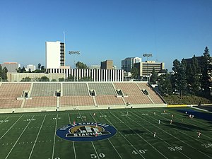
Santa Ana Stadium, also known as Eddie West Field or the Santa Ana Bowl, is a city-owned and operated 9,000-capacity American football and soccer stadium located in downtown Santa Ana. The field was named after Eddie West, a writer for the Orange County Register and tireless supporter of the Santa Ana College Dons and all Orange County sports. The city's stadium holds many events in addition to its high school and college football main draws, including children's and adult soccer games through local leagues, high school and college commencement ceremonies and more.
Santa Ana Fire Station Headquarters No. 1
United States historic place
Distance: Approx. 1885 meters
Latitude and longitude: 33.75638889,-117.86805556
Santa Ana Fire Station Headquarters No. 1, at 1322 N. Sycamore St. in Santa Ana, California, is a fire station which was built in 1929.

Orange County, California Superior Court
California superior court with jurisdiction over Orange County
Distance: Approx. 1954 meters
Latitude and longitude: 33.75065,-117.87534
The Superior Court of California, County of Orange, also known as the Orange County Superior Court or Orange Superior Court, is the California superior court with jurisdiction over Orange County.
Weather in this IP's area
clear sky
10 Celsius
9 Celsius
8 Celsius
12 Celsius
1011 hPa
50 %
1011 hPa
1007 hPa
10000 meters
1.54 m/s
40 degree
