199.195.54.3 - IP Lookup: Free IP Address Lookup, Postal Code Lookup, IP Location Lookup, IP ASN, Public IP
Country:
 USA
USARegion:
City:
Location:
Time Zone:
Postal Code:
ISP:
ASN:
language:
User-Agent:
Proxy IP:
Blacklist:
IP information under different IP Channel
ip-api
Country
Region
City
ASN
Time Zone
ISP
Blacklist
Proxy
Latitude
Longitude
Postal
Route
db-ip
Country
Region
City
ASN
Time Zone
ISP
Blacklist
Proxy
Latitude
Longitude
Postal
Route
IPinfo
Country
Region
City
ASN
Time Zone
ISP
Blacklist
Proxy
Latitude
Longitude
Postal
Route
IP2Location
199.195.54.3Country
usRegion
kansas
City
home
Time Zone
America/Chicago
ISP
Language
User-Agent
Latitude
Longitude
Postal
ipdata
Country
Region
City
ASN
Time Zone
ISP
Blacklist
Proxy
Latitude
Longitude
Postal
Route
Popular places and events near this IP address

Marshall County, Kansas
County in Kansas, United States
Distance: Approx. 5245 meters
Latitude and longitude: 39.8,-96.55
Marshall County is a county located in the U.S. state of Kansas. Its county seat and largest city is Marysville. As of the 2020 census, the county population was 10,038.
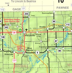
Beattie, Kansas
City in Marshall County, Kansas
Distance: Approx. 9175 meters
Latitude and longitude: 39.8625,-96.41777778
Beattie is a city in Marshall County, Kansas, United States. As of the 2020 census, the population of the city was 197. The city has been called "The Milo Capital of the World" and hosts the annual "Beattie Milo Festival".

Marysville, Kansas
City in Marshall County, Kansas
Distance: Approx. 9994 meters
Latitude and longitude: 39.84305556,-96.63861111
Marysville is a city in and the county seat of Marshall County, Kansas, United States. As of the 2020 census, the population of the city was 3,447.
Home, Kansas
Unincorporated community in Marshall County, Kansas
Distance: Approx. 170 meters
Latitude and longitude: 39.84166667,-96.51972222
Home is a census-designated place (CDP) in southern Franklin Township, Marshall County, Kansas, United States. As of the 2020 census, the population was 154. It lies along U.S. Route 36 – the Pony Express Highway – and a Union Pacific rail line, east of the city of Marysville.
Weather in this IP's area
clear sky
-0 Celsius
-0 Celsius
-0 Celsius
-0 Celsius
1022 hPa
80 %
1022 hPa
974 hPa
10000 meters