Country:
 USA
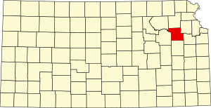
USARegion:
City:
Latitude and Longitude:
Time Zone:
Postal Code:
IP information under different IP Channel
ip-api
Country
Region
City
ASN
Time Zone
ISP
Blacklist
Proxy
Latitude
Longitude
Postal
Route
IPinfo
Country
Region
City
ASN
Time Zone
ISP
Blacklist
Proxy
Latitude
Longitude
Postal
Route
MaxMind
Country
Region
City
ASN
Time Zone
ISP
Blacklist
Proxy
Latitude
Longitude
Postal
Route
Luminati
Country
USRegion
ks
City
berryton
ASN
Time Zone
America/Chicago
ISP
MW-KANSAS
Latitude
Longitude
Postal
db-ip
Country
Region
City
ASN
Time Zone
ISP
Blacklist
Proxy
Latitude
Longitude
Postal
Route
ipdata
Country
Region
City
ASN
Time Zone
ISP
Blacklist
Proxy
Latitude
Longitude
Postal
Route
Popular places and events near this IP address
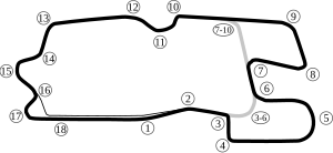
Heartland Motorsports Park
Defunct racetrack in Topeka, Kansas
Distance: Approx. 8246 meters
Latitude and longitude: 38.92661667,-95.67619722
Heartland Motorsports Park, formerly known as Heartland Park Topeka, was a multi-purpose motorsports facility 8 miles (13 km) south of downtown Topeka, Kansas near the Topeka Regional Airport. It operated from 1989 until its closure in 2023.

Topeka Regional Airport
Joint-use civil-military airport in Kansas, United States
Distance: Approx. 6823 meters
Latitude and longitude: 38.95083333,-95.66361111
Topeka Regional Airport (IATA: FOE, ICAO: KFOE, FAA LID: FOE), formerly known as Forbes Field, is a joint civil-military public airport owned by the Metropolitan Topeka Airport Authority in Shawnee County, Kansas, seven miles south of downtown Topeka, the capital city of Kansas. The National Plan of Integrated Airport Systems for 2011–2015 called it a general aviation airport. Topeka Regional Airport is used by the University of Kansas (KU) for charter flights for its athletic teams and by schools visiting the KU campus in Lawrence, which is 34 miles (55 km) east of the airport via the Kansas Turnpike.
Shawnee Heights High School
High school in Tecumseh, Kansas, United States
Distance: Approx. 5102 meters
Latitude and longitude: 38.990087,-95.56249
Shawnee Heights High School is a fully accredited public high school located in Tecumseh, Kansas, east of Topeka, Kansas. The school colors are red, white and turquoise and the school mascot is the Thunderbird. The average annual enrollment is approximately 1,200 students.

Berryton, Kansas
Unincorporated community in Shawnee County, Kansas
Distance: Approx. 4121 meters
Latitude and longitude: 38.94083333,-95.63166667
Berryton is an unincorporated community in Shawnee County, Kansas, United States. It is located east of the Topeka Regional Airport.

Richland, Kansas
Ghost town in Kansas, United States
Distance: Approx. 8137 meters
Latitude and longitude: 38.88361111,-95.53972222
Richland is currently a ghost town in southeastern Shawnee County, Kansas, United States.

Combat Air Museum
Aviation museum in Kansas, United States
Distance: Approx. 8068 meters
Latitude and longitude: 38.9411,-95.6777
The Combat Air Museum is a non-profit aviation museum at Topeka Regional Airport (Forbes Field) in Shawnee County, near Topeka, Kansas. The museum is dedicated to the creation of facilities and resources for the education of the local and regional communities through the collection, preservation, conservation and exhibition of aircraft, information, artifacts, technology and art associated with the military aviation history of the United States.
Shawnee Heights USD 450
Public school district in Tecumseh, Kansas
Distance: Approx. 4998 meters
Latitude and longitude: 38.98722222,-95.5575
Shawnee Heights USD 450 is a public unified school district headquartered in Tecumseh, Kansas, United States. The district includes the communities of southeast edge of Topeka, Tecumseh, Berryton, Watson, and nearby rural areas. The Shawnee Heights School District is a 5A school district that includes a total of 4 Elementary Schools, 1 Middle School, and 1 High School.
Monmouth Township, Shawnee County, Kansas
Township in Shawnee County, Kansas, U.S.
Distance: Approx. 3371 meters
Latitude and longitude: 38.92083333,-95.56694444
Monmouth township is located in the extreme southeast corner of Shawnee County, Kansas. There are currently no incorporated cities in Monmouth Township. Berryton is the largest unincorporated community.
Lake Jivaro
Reservoir in eastern Kansas
Distance: Approx. 7254 meters
Latitude and longitude: 39.0075,-95.5516
Lake Jivaro is a private man-made reservoir lake in southeast Shawnee County, Kansas. Constructed in the early 1960s, it lies just east of Shawnee Heights Road. The dam responsible for the lake is at the north end; the lake has roughly the shape of a doubly-rooted tooth.

Horace G. Lyons House
Historic house in Kansas, United States
Distance: Approx. 910 meters
Latitude and longitude: 38.95583333,-95.58388889
The Horace G. Lyons House is a historic house. It was built in 1860 for Horace G. Lyons, a settler and farmer. It was expanded in 1893.

Watson, Kansas
Unincorporated community in Shawnee County, Kansas
Distance: Approx. 5125 meters
Latitude and longitude: 38.98805556,-95.55638889
Watson is an unincorporated community in Shawnee County, Kansas, United States.
Lake Shawnee (Kansas)
Man-made lake in Shawnee County, Kansas
Distance: Approx. 7204 meters
Latitude and longitude: 39.00277778,-95.62861111
Lake Shawnee is a man-made lake in Shawnee County in the U.S. state of Kansas, located on the southeastern side of Topeka. The lake started construction in 1935, and finished on September 3, 1939, and was a part of a Works Progress Administration project. The lake's size is approximately 416 acres (1.68 km2), and has a maximum depth of 52 feet (16 m).
Weather in this IP's area
clear sky
12 Celsius
11 Celsius
10 Celsius
13 Celsius
1019 hPa
66 %
1019 hPa
980 hPa
10000 meters
07:25:14
18:53:54