199.189.189.249 - IP Lookup: Free IP Address Lookup, Postal Code Lookup, IP Location Lookup, IP ASN, Public IP
Country:
Region:
City:
Location:
Time Zone:
Postal Code:
IP information under different IP Channel
ip-api
Country
Region
City
ASN
Time Zone
ISP
Blacklist
Proxy
Latitude
Longitude
Postal
Route
Luminati
Country
Region
pa
City
arendtsville
ASN
Time Zone
America/New_York
ISP
AS-NSI-GLOBAL
Latitude
Longitude
Postal
IPinfo
Country
Region
City
ASN
Time Zone
ISP
Blacklist
Proxy
Latitude
Longitude
Postal
Route
IP2Location
199.189.189.249Country
Region
ontario
City
toronto
Time Zone
America/Toronto
ISP
Language
User-Agent
Latitude
Longitude
Postal
db-ip
Country
Region
City
ASN
Time Zone
ISP
Blacklist
Proxy
Latitude
Longitude
Postal
Route
ipdata
Country
Region
City
ASN
Time Zone
ISP
Blacklist
Proxy
Latitude
Longitude
Postal
Route
Popular places and events near this IP address

Queen Street, Toronto
Thoroughfare in Toronto, Ontario
Distance: Approx. 202 meters
Latitude and longitude: 43.649584,-79.39241
Queen Street is a major east–west thoroughfare in Toronto, Ontario, Canada. It extends from Roncesvalles Avenue and King Street in the west to Victoria Park Avenue in the east. Queen Street was the cartographic baseline for the original east–west avenues of Toronto's and York County's grid pattern of major roads.
Centre for Indigenous Theatre
Distance: Approx. 152 meters
Latitude and longitude: 43.64792,-79.39478
The Centre for Indigenous Theatre is a non-profit theater educational institution located in Toronto, Ontario. It focuses on performance art from an Indigenous cultural foundation.

The Rivoli
Toronto club
Distance: Approx. 231 meters
Latitude and longitude: 43.649276,-79.394914
The Rivoli is a bar, restaurant and performance space, established in 1982, on Queen Street West in Toronto, Ontario, Canada. The club originally earned a reputation as one of Canada's hippest music clubs, and many major Canadian comedy and musical performers have played on its stage, including The Kids in the Hall, Gordon Downie, The Frantics, Sean Cullen and the infamous Dark Shows. The Drowsy Chaperone premiered at the Rivoli and went on to subsequent productions and eventually a highly successful run on Broadway.

John Street (Toronto)
Street in Toronto, Ontario, Canada
Distance: Approx. 210 meters
Latitude and longitude: 43.6477,-79.3903
John Street is a street in Downtown Toronto. It runs from Stephanie Street and Grange Park in the north to the Metro Toronto Convention Centre on Front Street in the south. It is home to a number of Toronto's cultural institutions, including buildings for the CBC, CTV, Toronto International Film Festival.
Wynick/Tuck Gallery
Art gallery in Ontario, Canada
Distance: Approx. 153 meters
Latitude and longitude: 43.64782,-79.3948
Wynick/Tuck Gallery is a privately owned contemporary art gallery based in Toronto, Ontario, Canada. It is owned and operated by Lynne Wynick and David Tuck. Founded in 1968 as Aggregation Gallery, the gallery presented a wide program of over 500 exhibitions over 45 years.
Scotiabank Theatre Toronto
Cinema in Toronto, Ontario, Canada
Distance: Approx. 162 meters
Latitude and longitude: 43.648622,-79.391241
The Scotiabank Theatre Toronto (formerly Paramount Theatre Toronto) is a major movie theatre at the RioCan Hall in the Entertainment District of downtown Toronto, Ontario, Canada at Richmond and John Street owned by Cineplex Entertainment for the building and the lands owned by RioCan. Opened in 1999, the venue screens theatrical films throughout the year, but is best known as one of the major venues for the annual Toronto International Film Festival alongside the nearby TIFF Lightbox.
Balfour Building
High-rise in Ontario, Canada
Distance: Approx. 210 meters
Latitude and longitude: 43.647038,-79.395286
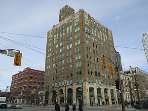
The Balfour Building is located at the Northeast corner of Spadina Avenue and Adelaide Street in downtown Toronto, Ontario, Canada, close to the Financial and Entertainment districts, Gardiner Expressway, and the LRT. It was named after Arthur J. Balfour, author of the "Balfour Declaration" in 1917, whose goal was for the British government to support a Jewish homeland in Palestine. The high-rise was built originally for the Schiffer-Hillman Clothing Company; it was managed by numerous Jewish clothing companies in its early years. Presently, the Balfour Building is a historical tower landmark of Art Deco style in the 1930s.
Prefix Institute of Contemporary Art
Art gallery in Toronto, Canada
Distance: Approx. 175 meters
Latitude and longitude: 43.647801,-79.395074
Prefix Institute of Contemporary Art is a public art gallery and an arts publishing house with a focus on contemporary photography, new media and digital arts. It is located in the 401 Richmond Street arts centre in Toronto, Canada. Prefix Photo magazine was founded by Canadian curator Scott McLeod in 1999 and has since expanded to include a programme of visual and audio art exhibitions, an international lecture series (the Urban Field Speaker Series), and a publicly accessible reference library.
A Space Gallery
Canadian artist-run centre
Distance: Approx. 133 meters
Latitude and longitude: 43.6478139,-79.3945565
A Space is a Canadian artist-run centre located in Toronto, Ontario
23 Hop
Warehouse event space in Toronto, Ontario, Canada
Distance: Approx. 139 meters
Latitude and longitude: 43.64894,-79.3922
23 Hop was a warehouse event space in Toronto, Ontario, Canada. It was an early venue for electronic music and a venue for raves. It was located at 318 Richmond Street West in the city's former Garment District which had recently become re-zoned into the city's Entertainment District.
Grasett Park
Public park in Toronto
Distance: Approx. 137 meters
Latitude and longitude: 43.6475,-79.39125
Grasett Park is situated at the corner of Adelaide Street West and Widmer Street in downtown Toronto, Canada. It is a public space that commemorates Dr. George Robert Grasett who, in the summer of 1847, gave his life to care for Irish migrants fleeing the Great Famine, many of whom arrived in Toronto sickened or dying from typhus, then known as ship fever.

Hyatt Regency Toronto
Hotel in Toronto, Ontario
Distance: Approx. 175 meters
Latitude and longitude: 43.6464799,-79.39171
The Hyatt Regency Toronto is a 394-room, 19-floor hotel in the Entertainment District of Toronto, Ontario. The hotel opened as a Holiday Inn in 1990 and has been operated by Hyatt since 2009.
Weather in this IP's area
broken clouds
1 Celsius
-7 Celsius
-1 Celsius
2 Celsius
1014 hPa
69 %
1014 hPa
1004 hPa
10000 meters
11.32 m/s
14.4 m/s
260 degree
75 %


