Country:
 USA
USARegion:
City:
Latitude and Longitude:
Time Zone:
Postal Code:
IP information under different IP Channel
ip-api
Country
Region
City
ASN
Time Zone
ISP
Blacklist
Proxy
Latitude
Longitude
Postal
Route
IPinfo
Country
Region
City
ASN
Time Zone
ISP
Blacklist
Proxy
Latitude
Longitude
Postal
Route
MaxMind
Country
Region
City
ASN
Time Zone
ISP
Blacklist
Proxy
Latitude
Longitude
Postal
Route
Luminati
Country
USRegion
ia
City
cedarrapids
ASN
Time Zone
America/Chicago
ISP
IMONC
Latitude
Longitude
Postal
db-ip
Country
Region
City
ASN
Time Zone
ISP
Blacklist
Proxy
Latitude
Longitude
Postal
Route
ipdata
Country
Region
City
ASN
Time Zone
ISP
Blacklist
Proxy
Latitude
Longitude
Postal
Route
Popular places and events near this IP address

University Heights, Iowa
City in Iowa, United States
Distance: Approx. 1422 meters
Latitude and longitude: 41.65361111,-91.55805556
University Heights is a city in Johnson County, Iowa, United States. It is part of the Iowa City, Iowa Metropolitan Statistical Area. The population was 1,228 at the time of the 2020 census.

Kinnick Stadium
University of Iowa football stadium
Distance: Approx. 2218 meters
Latitude and longitude: 41.65861111,-91.55111111
Kinnick Stadium is a stadium located in Iowa City, Iowa, United States. It is the home stadium of the University of Iowa Hawkeyes football team. First opened in 1929 as Iowa Stadium to replace Iowa Field, it currently holds up to 69,250 people, making it the 7th largest stadium in the Big Ten, and one of the 20 largest university owned stadiums in the nation.
University of Iowa Hospitals & Clinics
Hospital in Iowa, United States
Distance: Approx. 2348 meters
Latitude and longitude: 41.658,-91.548
University of Iowa Hospitals & Clinics (UIHC) is an 811-bed public teaching hospital and level 1 trauma center affiliated with the University of Iowa. UI Hospitals and Clinics is part of University of Iowa Health Care, a partnership that includes the University of Iowa Roy J. and Lucille A. Carver College of Medicine and the University of Iowa Physicians group practice. It is located on the university campus in Iowa City, Iowa at Melrose Avenue and Hawkins Drive near Kinnick Stadium.

Iowa Field House
Stadium in Iowa, United States
Distance: Approx. 2485 meters
Latitude and longitude: 41.6586,-91.5465
The Iowa Field House is a multi-purpose arena in Iowa City, Iowa. Opened in 1927, it held up to 13,365 people at its height. At one time, it housed all Iowa athletic teams and coaching offices before the construction of additional facilities, most notably Carver-Hawkeye Arena.
Iowa City West High School
Public secondary school in Iowa City, Iowa, United States
Distance: Approx. 1638 meters
Latitude and longitude: 41.65444444,-91.58166667
Iowa City West High School is a public high school in Iowa City, Iowa. It serves grades 9–12 for the Iowa City Community School District.
Iowa City Municipal Airport
Civil airport with no airline service
Distance: Approx. 1902 meters
Latitude and longitude: 41.63916667,-91.54638889
Iowa City Municipal Airport (IATA: IOW, ICAO: KIOW, FAA LID: IOW), is two miles southwest of downtown Iowa City, in Johnson County, Iowa. It is the oldest civil airport west of the Mississippi River still in its original location. The Federal Aviation Administration (FAA) National Plan of Integrated Airport Systems for 2017–2021 categorized it as a regional general aviation facility.

Duane Banks Field
Baseball stadium in Iowa City, Iowa
Distance: Approx. 2203 meters
Latitude and longitude: 41.6612564,-91.5567949
Duane Banks Field is a baseball stadium in Iowa City, Iowa, United States. It is the home field of the University of Iowa Hawkeyes college baseball team. The stadium holds 3,000 people and opened in 1974.
University of Iowa Children's Hospital
Hospital in Iowa, United States
Distance: Approx. 2306 meters
Latitude and longitude: 41.658413,-91.549252
University of Iowa Stead Family Children's Hospital formerly University of Iowa Children's Hospital and Children's Hospital of Iowa is a pediatric acute care academic children's hospital located in Iowa City, Iowa. The hospital was founded in 1919 and its current facility, opened in 2017, overlooks the university's football home, Kinnick Stadium. The hospital has 190 inpatient pediatric beds and is affiliated with the University of Iowa Carver College of Medicine.
University of Iowa College of Dentistry
Dental school in Iowa City, Iowa, US
Distance: Approx. 2190 meters
Latitude and longitude: 41.657355,-91.549805
The University of Iowa College of Dentistry is the dental school of the University of Iowa. It is located in Iowa City, Iowa, United States. It is the only dental school in Iowa and is one of only two dental colleges in the United States to offer all the American Dental Association (ADA) accredited dental specialty training programs.
Roy J. and Lucille A. Carver College of Medicine
Distance: Approx. 2500 meters
Latitude and longitude: 41.660168,-91.548364
The Roy J. and Lucille A. Carver College of Medicine (also known as CCOM or Carver) is the medical school of the University of Iowa, located in Iowa City, Iowa, United States. The first medical college associated with the University of Iowa was founded in 1850, in the small town of Keokuk, Iowa, but the current Iowa City program can trace its roots to 1870. The program became notable as the first co-educational medical school in the United States, and was one of 22 original members of the Association of American Medical Colleges in 1876.
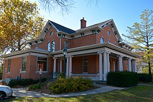
A. W. Pratt House
Historic house in Iowa, United States
Distance: Approx. 2371 meters
Latitude and longitude: 41.65652778,-91.54594444
The A. W. Pratt House, also known as the Pratt-Soper House, is a historic building located in Iowa City, Iowa, United States. The A. W. and Fanny Pratt family was among the first settlers in Johnson County. Albert W. Pratt, who had this house built in 1885, was one of their seven children.
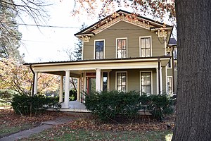
Billingsley-Hills House
Historic house in Iowa, United States
Distance: Approx. 2223 meters
Latitude and longitude: 41.65652778,-91.54825
The Billingsley-Hills House, also known as the Veatch Residence, is a historic building located in Iowa City, Iowa, United States. This is one of several transitional Greek Revival to Italianate houses built in this area in the years before and after the American Civil War making it a very popular style here. Over the years, however, most of them have either been torn down or altered beyond recognition leaving this house as one of few left with its integrity intact.
Weather in this IP's area
clear sky
31 Celsius
32 Celsius
30 Celsius
32 Celsius
1009 hPa
48 %
1009 hPa
986 hPa
10000 meters
7.2 m/s
10.29 m/s
180 degree
06:51:09
19:08:42