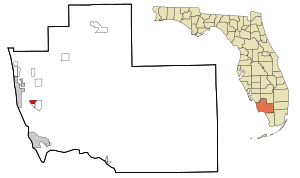
Country:
Region:
City:
Latitude and Longitude:
Time Zone:
Postal Code:
IP information under different IP Channel
ip-api
Country
Region
City
ASN
Time Zone
ISP
Blacklist
Proxy
Latitude
Longitude
Postal
Route
Luminati
Country
Region
fl
City
kissimmee
ASN
Time Zone
America/New_York
ISP
ORLANDOTELCO
Latitude
Longitude
Postal
IPinfo
Country
Region
City
ASN
Time Zone
ISP
Blacklist
Proxy
Latitude
Longitude
Postal
Route
db-ip
Country
Region
City
ASN
Time Zone
ISP
Blacklist
Proxy
Latitude
Longitude
Postal
Route
ipdata
Country
Region
City
ASN
Time Zone
ISP
Blacklist
Proxy
Latitude
Longitude
Postal
Route
Popular places and events near this IP address

Lely, Florida
Census-designated place in Florida
Distance: Approx. 7093 meters
Latitude and longitude: 26.10277778,-81.73305556
Lely is a census-designated place (CDP) in Collier County, Florida, United States. The population was 3,694 at the 2020 census, up from 3,451 at the 2010 census. It is part of the Naples–Marco Island Metropolitan Statistical Area.

Lely Resort, Florida
Census-designated place in Florida
Distance: Approx. 4706 meters
Latitude and longitude: 26.08111111,-81.70083333
Lely Resort is a census-designated place (CDP) in Collier County, Florida, United States. The population was 7,619 at the 2020 census, up from 4,646 at the 2010 census. It is part of the Naples–Marco Island Metropolitan Statistical Area.

Marco Island, Florida
City in Florida, United States
Distance: Approx. 7739 meters
Latitude and longitude: 25.9725,-81.72888889
Marco Island is a city and barrier island in Collier County, Florida, 20 miles (32 km) south of Naples on the Gulf Coast of the United States. It is the largest barrier island in Southwest Florida's Ten Thousand Islands area, which extends southerly to Cape Sable. Marco Island is home to an affluent beach community with resort amenities.

Naples Manor, Florida
Census-designated place in Florida
Distance: Approx. 5503 meters
Latitude and longitude: 26.08972222,-81.725
Naples Manor is a census-designated place (CDP) in Collier County, Florida, United States. The population was 5,132 at the 2020 census, down from 5,562 at the 2010 census. It is part of the Naples–Marco Island Metropolitan Statistical Area.
Keewaydin Island
Distance: Approx. 6290 meters
Latitude and longitude: 26.04611111,-81.77833333
Keewaydin Island is a primary barrier island located off the coast of Naples, in Collier County, Florida, United States. It can be reached only by boat. It is managed by the State of Florida's Coastal Office, in cooperation with NOAA, within the Rookery Bay National Estuarine Research Reserve.
Chubb Classic
Annual golf tournament in Florida, U.S.
Distance: Approx. 5783 meters
Latitude and longitude: 26.091,-81.7
The Chubb Classic is a golf tournament on the PGA Tour Champions, held annually in February in Naples, Florida. It has been played at a variety of courses, and Chubb Corporation is the main sponsor. It debuted 36 years ago in 1988 as the Aetna Challenge,.
Rookery Bay National Estuarine Research Reserve
Distance: Approx. 7961 meters
Latitude and longitude: 25.971621,-81.735
Rookery Bay National Estuarine Research Reserve protects 110,000 acres of coastal lands and waters at the northern end of the Ten Thousand Islands on the gulf coast of Florida, representing one of the few remaining undisturbed mangrove estuaries in North America. Its ecosystem is a prime example of a nearly pristine subtropical mangrove forested estuary. It is located in the West Florida subregion of the West Indian Biogeographic Region.
Lely High School
Public school
Distance: Approx. 5542 meters
Latitude and longitude: 26.0906485,-81.7198087
Lely High School is a four-year public high school located in Lely Resort, Collier County, Florida, about 10 miles (16 km) southeast of Downtown Naples. The school serves Naples Manor, Marco Island, Lely, Verona Walk, and some unincorporated areas of Collier County. The school is a part of the District School Board of Collier County.
Verona Walk, Florida
Census-designated place in Florida
Distance: Approx. 6343 meters
Latitude and longitude: 26.08722222,-81.67861111
Verona Walk is a census-designated place (CDP) in Collier County, Florida, United States. The population was 2,713 at the 2020 census, up from 1,782 at the 2010 census. It is part of the Naples–Marco Island Metropolitan Statistical Area.
Isles of Capri, Florida
Distance: Approx. 6588 meters
Latitude and longitude: 25.98277778,-81.7275
Isles of Capri is an island community located in unincorporated Collier County, Florida. The isles are a grouping of four mangrove islands that were developed and connected in the 1950s. The isles are connected by Capri Boulevard, and can be accessed from nearby SR 951 (Collier Boulevard).
Winding Cypress, Florida
Census-designated place in Florida, United States
Distance: Approx. 4472 meters
Latitude and longitude: 26.06416667,-81.67916667
Winding Cypress is a census-designated place (CDP) in western Collier County, Florida, United States. It is 9 miles (14 km) southeast of Naples and is bordered to the southwest by U.S. Route 41 (Tamiami Trail) and to the north by the community of Verona Walk. Winding Cypress was first listed as a CDP prior to the 2020 census.
Marco Shores-Hammock Bay, Florida
Census-designated place in Florida, United States
Distance: Approx. 5188 meters
Latitude and longitude: 25.99944444,-81.69222222
Marco Shores-Hammock Bay is a census-designated place (CDP) in western Collier County, Florida, United States. It is 13 miles (21 km) southeast of Naples and 3 miles (5 km) north of Marco Island, and contains the Hammock Bay Golf and Country Club and the Marco Island Executive Airport. It is bordered to the west by Florida State Road 951 (Collier Boulevard) and to the south by McIlvane Bay.
Weather in this IP's area
few clouds
25 Celsius
26 Celsius
24 Celsius
25 Celsius
1012 hPa
99 %
1012 hPa
1012 hPa
10000 meters
4.12 m/s
80 degree
20 %
06:39:14
17:41:49
